

Storms trigger catastrophic flooding with hundreds of thousands still without power across Midwest
In addition to the flooding, more severe storms capable of producing damaging wind gusts are expected across central and southern Illinois, Indiana and western Kentucky through Wednesday evening.
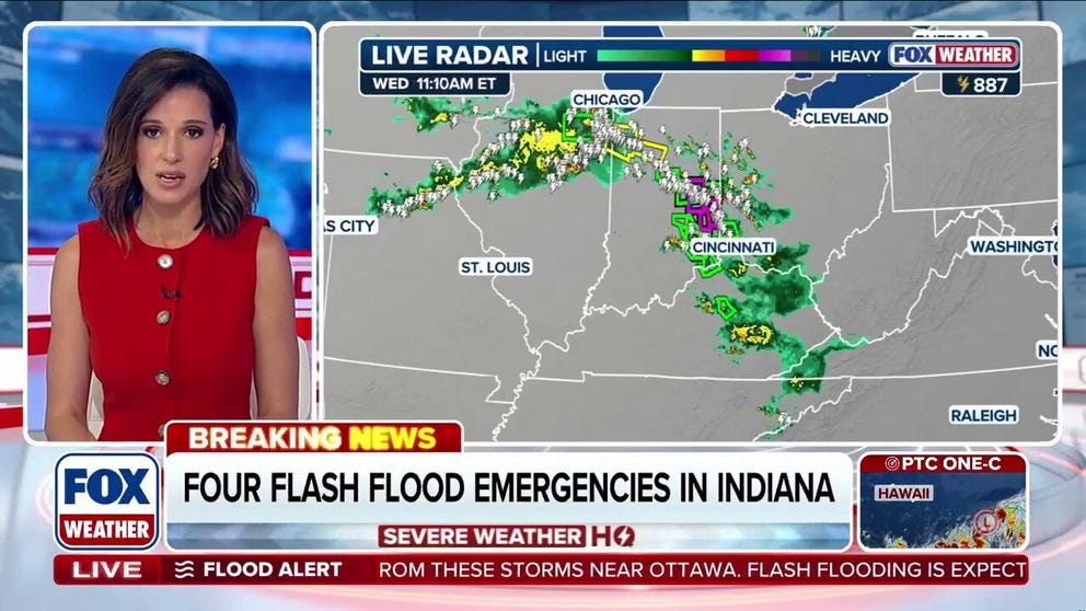
Flash Flood Emergencies issued across parts of Indiana as severe storm threat returns to Midwest
Torrential rain prompted the National Weather Service (NWS) to issue several Flash Flood Emergencies for life-threatening flash flooding across east-central Indiana late Wednesday morning with more than 700,000 customers still without power after a deadly windstorm raced parts of the Midwest and the Ohio Valley Tuesday.
Torrential rain prompted the National Weather Service (NWS) to issue several Flash Flood Emergencies for life-threatening flash flooding across east-central Indiana late Wednesday morning with more than 700,000 customers still without power after a deadly windstorm raced parts of the Midwest and the Ohio Valley Tuesday.
In addition to the flooding, more severe storms capable of producing damaging wind gusts are expected across central and southern Illinois, Indiana and western Kentucky through Wednesday evening.
WHAT ARE TRAINING THUNDERSTORMS, AND WHY ARE THEY SO DANGEROUS?
![Flash flooding swamps Cambridge City, Indiana, on Aug. 12, 2026.]() Image 1 of 5
Image 1 of 5Flash flooding swamps Cambridge City, Indiana, on Aug. 12, 2026. (Cambridge City Indiana Police Department/Facebook)
![A line of severe storms rolls into Chicagoâs Austin neighborhood from the west along West Madison Street on Tuesday, Aug. 11, 2026.]() Image 2 of 5
Image 2 of 5A line of severe storms rolls into Chicagoâs Austin neighborhood from the west along West Madison Street on Tuesday, Aug. 11, 2026. ((Brian Cassella/Chicago Tribune/Tribune News Service via Getty Images))
![]() Image 3 of 5
Image 3 of 5Heavy rain led to severe flooding and power outages across Ohio. (Muskingum County Sheriff's Office)
![]() Image 4 of 5
Image 4 of 5A Roseville resident’s home was destroyed as heavy rain impacted the region. (Jennifer Thomas )
![]() Image 5 of 5
Image 5 of 5Heavy rain caused severe flooding that destroyed numerous homes in Roseville, Ohio. (Jennifer Thomas )



Police in Cambridge City, Indiana, posted video Wednesday of Main Street inundated with several feet of water as rescue teams worked in the flooded area.
City officials in Muncie, Indiana, said firefighters went door-to-door to evacuate people from their homes.

DRONE VIDEO: Indiana town swallowed by floodwaters as drone captures widespread devastation
An entire community swallowed by floodwater. Jaw-dropping drone video reveals the staggering scale of destruction in Cambridge City, Indiana, after catastrophic flash flooding turned streets into raging rivers and inundated entire neighborhoods. One lifelong resident called it
Flash Flood Emergencies were issued for parts of Delaware, Fayette, Union, Wayne and Franklin counties Wednesday, with some remaining in effect through the afternoon.
Local travel restrictions were issued due to impassable roads.
The Fayette County Sheriff's Office said several vehicles were swept off flooded roadways, although no injuries have been reported.

Flash flooding swamped Muncie, Indiana, Wednesday, triggering a Flash Flood Emergency, one of many areas across the state impacted by devastated flooding.
(Aaron Brogan/LiveStormChasers.com)
NOAA's Storm Prediction Center (SPC) has issued a Level 2 out of 5 risk of severe thunderstorms for central and southern Illinois, Indiana and western Kentucky.
This includes the outskirts of St. Louis, Indianapolis and Louisville, with damaging winds once again being the main concern.

(FOX Weather)
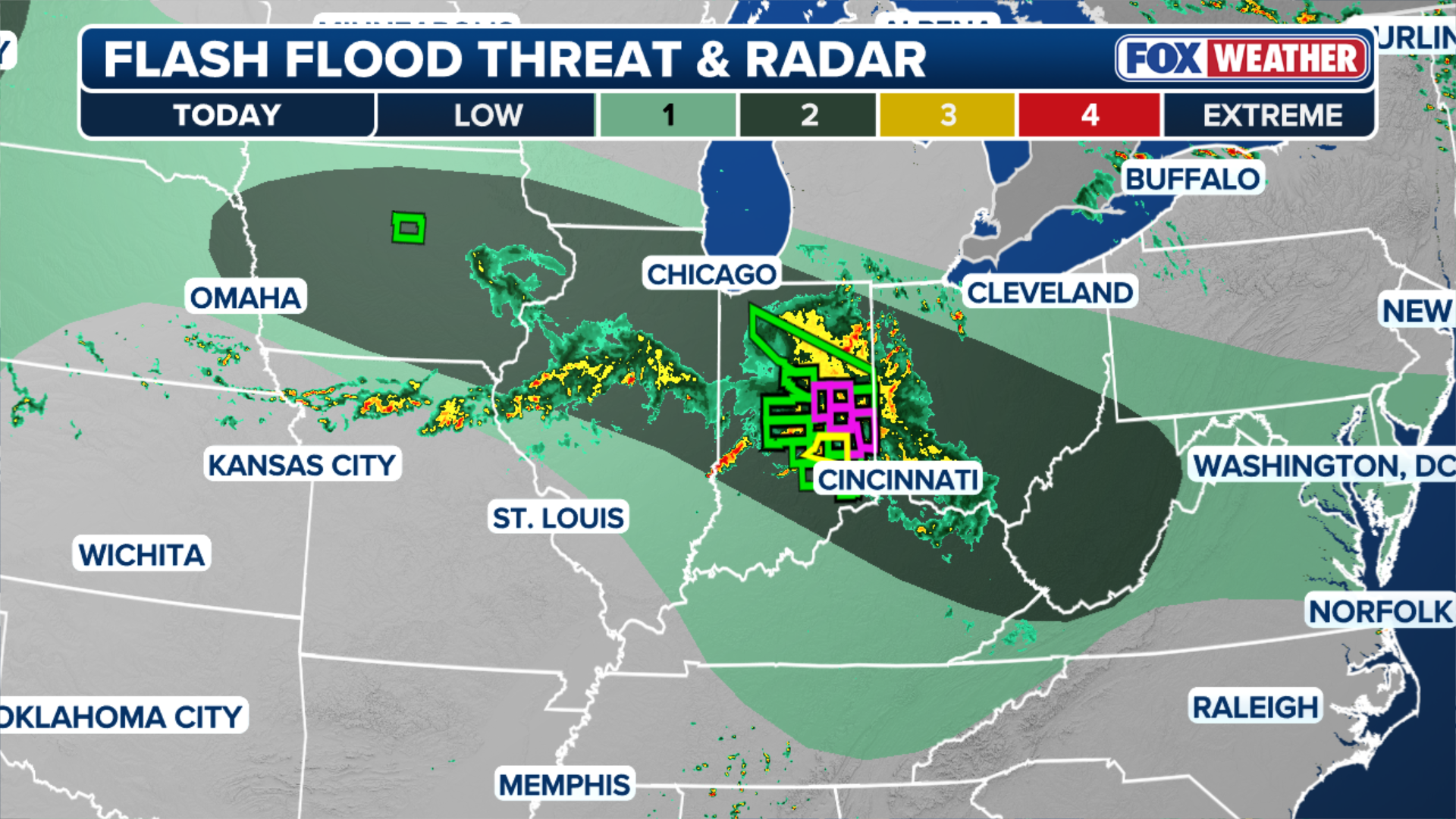
This stormy pattern will remain over the region for much of the week, with thunderstorms tapping into high humidity to produce heavy rain and a flash flood threat as storms repeatedly track over the same areas.
Meanwhile, A Level 2 out of 4 flash flood threat covers Chicago, northern Indiana, south and central Ohio, and West Virginia.
Flood Watches are now in place through Friday morning across portions of Indiana, Ohio, West Virginia, northeast Kentucky, western Virginia, Pennsylvania, North Carolina and East Tennessee.
(FOX Weather)
More than 700,000 customers were still without power early Wednesday afternoon, with most of the outages concentrated across Ohio, Illinois and Indiana.
Damaging winds swept into Illinois, triggering Tornado Warnings across several areas Tuesday afternoon — including Aurora, Joliet, Naperville and downtown Chicago.

A line of severe storms rolls into Chicagoâs Austin neighborhood from the west along West Madison Street on Tuesday, Aug. 11, 2026.
((Brian Cassella/Chicago Tribune/Tribune News Service via Getty Images) / Getty Images)
A 4-year-old was killed when a tree fell on a home in Geneva Township, Indiana, during severe storms on Tuesday, according to the Jennings County Sheriff's Office.
In Ohio, Gov. Mike DeWine confirmed one person was killed after emergency responders were unable to reach the individual during a flooding emergency.
Police in Portage, Indiana, said a home exploded shortly after the storms passed, killing one person. Investigators are working to determine whether the storms caused the explosion.
Meanwhile, 16 people were struck by lightning at the Grafton Correctional Institution. Initial reports indicate the lightning strike occurred Tuesday evening as incarcerated individuals were returning from their evening meal.
The individuals were transported to an outside hospital for treatment, including one person who was airlifted. No deaths have been reported in connection to the incident.

Rounds of severe storms and flash flooding have returned to Ohio
Severe storms and flash flooding have returned to portions of the Midwest, Ohio Valley and the Northeast bringing significant rain. Some areas reported over 6.5 inches of rain was reported within just a few hours.
The FOX Forecast Center said Tuesday's storms were confirmed to be a derecho. In order to be classified as a derecho, a storm needs to stretch at least 250 miles long and be at least 60 miles wide.
According to the FOX Forecast Center, destructive storms with 90 to 100 mph winds moved across northern Indiana and extreme southern Michigan. Ground stops were in effect at nearly every major Northeast airport in the evening.
16 PEOPLE TAKEN TO THE HOPSITAL AFTER LIGHTNING STRIKES OHIO PRISON
Dangerous flooding remained on the ground Tuesday morning, with local reports of active water rescues.
According to the FOX Forecast Center, over 6.5 inches of rain was reported within just a few hours.

Heavy rain led to severe flooding and power outages across Ohio.
(Muskingum County Sheriff's Office / FOX Weather)
All of this comes on the heels of Monday’s destructive storms that brought 65 mph winds to Maryland and Virginia, knocking power out to tens of thousands of customers there.