NASA's new TROPICS satellites show Hurricane Adrian's intensification
Using data from TROPICS, NASA released new video and images showing cold-brightness temperatures in Hurricane Adrian's storm clouds.

NASA TROPICS satellites show Hurricane Adrian in Pacific Ocean
NASA's newest weather asset, four small small satellites part of the TROPICS mission, launched in May. The satellites acquired data for Hurricane Adrian as it developed off the west coast of Mexico.
Researchers wasted no time putting a new tiny fleet of NASA satellites to use studying tropical systems for the 2023 hurricane season.
NASA's TROPICS satellite launched in May on Rocket Lab's Electron rocket from New Zealand, about a month before the start of the Atlantic hurricane season. According to NASA, the four CubeSats were operating as the Pacific hurricane season got underway and were able to watch Hurricane Adrian develop and intensify in the Pacific Ocean.
The shoe-box-sized TROPICS satellites were designed to observe the tropics by gathering data on temperature, moisture and precipitation around storms. Initially designed to be a fleet of six small satellites, two were lost after launching on Astra's rocket from Florida in February 2022. NASA said the remaining four TROPICS satellites launched by Rocket Lab in May are enough to continue the research.
Two hurricanes formed in the last week of June in the eastern Pacific – Adrian and Beatriz.
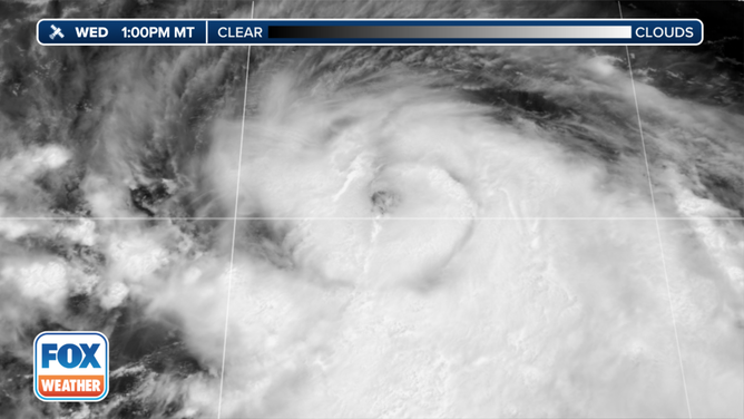
Satellite image of Hurricane Adrian in late June.
(FOX Weather)
Using data from TROPICS, NASA released new video and images showing cold-brightness temperatures in Adrian's storm clouds.
The colder, bluer colors indicate there is more ice in the clouds which can point to convection in a storm.
TROPICS project scientists Scott Braun, a research meteorologist with NASA's Goddard Space Flight Center, said patterns in the brightness-temperature data can show the location of rain bands, the intensity of convection and if an eye has formed. These are all important for understanding how a tropical system will strengthen or weaken.
"We're trying to understand the fundamental processes of the storms, but the endgame is to improve the forecasting, use that understanding, to improve the modeling and the assimilation so that we can better forecast the track of the storm and the intensity of the storm," TROPICS Principal Investigator William Blackwell, with MIT Lincoln Laboratory, told FOX Weather before the first launch.

This series of still images, produced with data acquired by TROPICS, shows structural changes within Hurricane Adrian as the storm intensified. (Image credits: NASA Earth Observatory images by Lauren Dauphin, using data provided by the TROPICS team.)
(NASA)
In the image series above, you can see Adrian's developing eye, which was taken around the time the National Hurricane Center upgraded the system from a tropical storm to a Category 1 hurricane.
Because there are multiple TROPICS satellites, the small spacecraft are able to collect data on storms once an hour compared to the 6- to 12-hour orbits of larger satellites.
The small satellites will have plenty more observation time during the Atlantic hurricane season, which runs through Nov. 30.