Arctic sets record for smallest winter ice coverage
Antarctic sea ice typically reaches its minimum in February and reaches its maximum extent in September, after the Southern Hemisphere’s winter.

World ice coverage animation
Antarctic sea ice typically reaches its minimum in February and reaches its maximum extent in September, after the Southern Hemisphere’s winter.
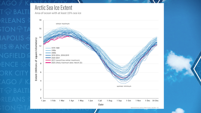
This season’s Arctic sea ice coverage was the smallest in the 47-year history of satellite records, according to data released by the National Snow and Ice Data Center.
The winter peak is estimated to have occurred on March 22, with just 5.53 million square miles of sea ice - which was not only below the long-term average, but it also reached its maximum ten days later than usual, a shift likely driven by climate change.
"All ten of the smallest winter maximum extents in the satellite record have occurred since 2007," the NSIDC noted in a statement.
This year now surpassed previous low-ice years such as 2015, 2016, 2017 and 2018.
According to NSIDC data, winter maximums have been declining at a rate of about 2.5% per decade, while summer minimums have dropped by more than 12% since 1979.
During the North Pole’s summer, sea ice typically shrinks to between 1 and 2 million square miles — roughly four times less than in the winter.
Arctic Sea Ice Extent Chart
(NOAA)
ANTARCTICA'S ‘DOOMSDAY GLACIER’ IS MELTING AWAY DIFFERENTLY SCIENTISTS FIRST THOUGHT
According to sea ice experts, above-average air temperatures of 2 to 4 degrees Fahrenheit likely played a role in the lack of formation, especially in regions such as the Gulf of St. Lawrence and the Sea of Okhotsk, which saw significantly lower ice coverage than normal.
Satellites showed some parts of the Arctic seeing more ice than average, but the formation was not extensive enough to make up for deficits seen elsewhere.
Similar extremes were also reported around the South Pole, where Antarctic sea ice reached just 764,000 square miles in 2025, tying with 2022 and 2024 for the lowest levels on record.
"Overall, the downward trend in the annual Antarctic sea ice minimum extent computed over the complete satellite record is 6,500 square kilometers (2,500 square miles) per year, or 2.3 percent per decade relative to the 1981 to 2010 average," the NSIDC said.
According to NASA, Antarctica loses about 150 billion tons of ice per year, and melting around Greenland leads to an additional 270 billion tons of ice that is lost.
WORLD’S LARGEST ICEBERG RUNS AGROUND BEFORE COLLISION WITH SUB-ANTARCTIC ISLAND
While changes in sea ice carry dramatic implications for ecosystems as well as shipping, recent studies have suggested that a lack of ice formation can also impact weather patterns in the U.S. and around the world.
A study published in the Journal of Climate said there is a distinct possibility of fewer cold air invasions in southern latitudes as ice coverage decreases.
"It’s not yet clear whether the Southern Hemisphere has entered a new norm with perennially low ice or if the Antarctic is in a passing phase that will revert to prior levels in the years to come," Walt Meier, a scientist with NSIDC, stated in a statement.
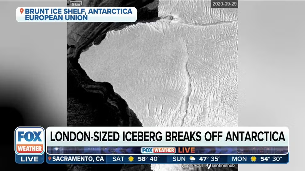
Iceberg the size of London breaks off Antarctica
Head of Mapping and Geospatial Group at the British Antarctic Survey Andrew Fleming says cracks on Antarctica’s Brunt Ice Shelf are naturally occurring and led to the new iceberg forming.