NASA satellite captures odd holes in clouds over Florida. What are they?
The photo captured by the Moderate Resolution Imaging Spectroradiometer (MODIS) on NASA's Terra satellite shows a cluster of circle- or ellipse-shaped figures that look like they've been cut neatly from the clouds. They even depict "feathery wisps" in the middle of the hole, NASA said.
FILE – Surreal clouds spotted across Texas, Southeast
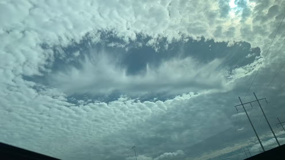
Widespread sightings of eerie holes in clouds, known as "fallstreak clouds," were reported from Texas across the South and into the Carolinas back in January.
High above the Gulf of Mexico and just off the coast of Florida, NASA's Terra satellite recently captured a striking image of the sky, revealing some odd clouds that have puzzled scientists for decades. However, thanks to research conducted over 13 years ago, we now have a clearer understanding of what these mysterious clouds are – and what they were doing over the Sunshine State on Jan. 30.
The photo captured by the Moderate Resolution Imaging Spectroradiometer (MODIS) on NASA's Terra satellite shows a cluster of circle- or ellipse-shaped figures that look like they've been cut neatly from the clouds. They even depict "feathery wisps" in the middle of the hole, NASA said.
'HOLEY' MACKEREL SKY! DOZENS OF PLANES PUNCH HOLES INTO CLOUDS ACROSS THE SOUTHEAST
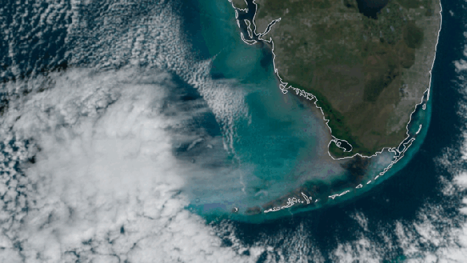
High above the Gulf of Mexico and just off the coast of Florida, NASA's Terra satellite recently captured a striking image of the sky, revealing some odd clouds that have puzzled scientists for decades.
(NASA)
These are called cavum clouds, also known as hole-punch clouds or fallstreak holes. They're caused by airplanes moving through banks of altocumulus clouds, according to NASA, citing a study published in 2010 and 2011 led by University Corporation for Atmospheric Research (UCAR) scientists.
NASA said these mid-level clouds are made up of liquid water droplets that are "supercooled." That means the droplets remain liquid even when temperatures drop below the typical freezing point of water, which is 32 degrees.
"Supercooling happens when water droplets are exceptionally pure and lack small particles, such as dust, fungal spores, pollen, or bacteria, around which ice crystals typically form," NASA said. "Supercooling may sound exotic, but it occurs routinely in Earth’s atmosphere. Altocumulus clouds, which cover about 8 percent of Earth’s surface at any given time, are mostly composed of liquid water droplets supercooled to a temperature of about (5 degrees Fahrenheit)."
Supercooled clouds do have their limits, though.
"As air moves around the wings and past the propellers of airplanes, a process known as adiabatic expansion cools the water by an additional (68 degrees Fahrenheit) or more and can push liquid water droplets to the point of freezing without the help of airborne particles," NASA said. "Ice crystals beget more ice crystals as the liquid droplets continue to freeze. The ice crystals eventually grow heavy enough that they begin to fall out of the sky, leaving a void in the cloud layer. The falling ice crystals are often visible in the center of the holes as wispy trails of precipitation that never reach the ground–features called virga."
UCAR scientists ultimately discovered that when planes – including large passenger jets, regional jets, private jets, military jets and turboprops – passed through clouds, they could produce either cavum or canal clouds. Cavum clouds are produced when planes pass through at a fairly sharp angle, while canal clouds with lengthy virga trails appear when planes pass at a longer, shallow angle.
THE PLANE TRUTH: WHAT MADE THIS SPOOKY-LOOKING CLOUD NEAR PORTLAND?
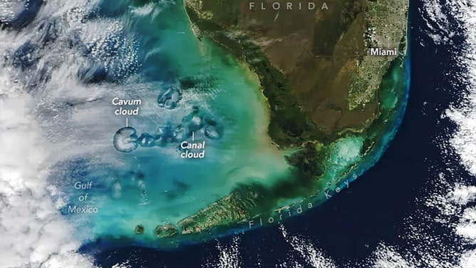
UCAR scientists ultimately discovered that when planes passed through clouds, they could produce either cavum or canal clouds.
(NASA)
In Florida, scientists said there are many opportunities for planes to enter the atmospheric conditions needed to produce cavum clouds – especially at Miami International Airport, where more than 1,000 flights arrive daily.