Bryan Norcross: Atlantic tropical disturbance has a good chance of developing next week
The National Hurricane Center is giving the system a good (medium) chance of developing into at least a tropical depression in the next week, but skillful computer models show the system strengthening into at least a tropical storm over the open ocean.
Tracking a new tropical disturbance in the Atlantic
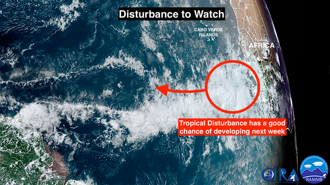
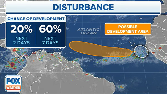
FOX Weather Hurricane Specialist Bryan Norcross explains why the tropical wave off Africa is worth watching for development. The system has a 20% chance of development in the next week, according to the National Hurricane Center.
The robust tropical disturbance on the far side of the Atlantic is forecast to track west over ocean water that is extremely warm for June. Meanwhile, the atmospheric pattern is forecast to become conducive for the disturbance to organize and strengthen.
The National Hurricane Center is giving the system a good (medium) chance of developing into at least a tropical depression in the next week, but skillful computer models show the system strengthening into at least a tropical storm over the open ocean.
As far as we know, the spectacularly warm ocean water in the far eastern Atlantic from the British Isles south to Africa and stretching across the tropical Atlantic is unprecedented. Since the water temperature over large parts of the ocean influences the flow in the atmosphere, and the atmosphere affects the water temperatures, the cause and effect are often hard to pin down. But worldwide, the ocean water is record warm, so it’s likely the ocean is the driver in this case.

A disturbance has emerged off the coast of Africa.
(FOX Weather)
An effect of the extra warm water is to weaken the typical high-pressure system that sits across the Atlantic – the so-called Bermuda High. When the high is weak, it pushes less air across the Atlantic, meaning the trade winds are weaker. Weaker winds stir up the ocean less, which means the colder water isn’t mixed up to the surface. Also, weaker winds blowing across the ocean generally means that the atmospheric pattern is less hostile to tropical systems developing.
The weaker high-pressure system might also limit the amount of Saharan dust transported over the tropical Atlantic, although other factors in Africa contribute to the creation of dust plumes.
So far this month, the weaker Bermuda High has mostly stayed over the ocean instead of pushing west over the U.S. Waves of low pressure have dominated the eastern part of the country, which has brought storminess to the South and cooler-than-normal temperatures to the big cities of the Northeast, among other effects. Long-range computer forecast models continue some version of this unusual configuration of high and low pressure.

The NHC gives the disturbance a 60% chance for development over the next week.
The good news is, however, that low pressure over the eastern U.S. means that tropical systems should get shunted north before they can reach the East Coast. It’s a long hurricane season, however, so we’ll see how things develop.
In the short term, residents in the northeastern Caribbean islands should watch developments with the tropical disturbance next week. Long-range computer models show the possibility of a significant storm moving in their general direction mid- to late week.
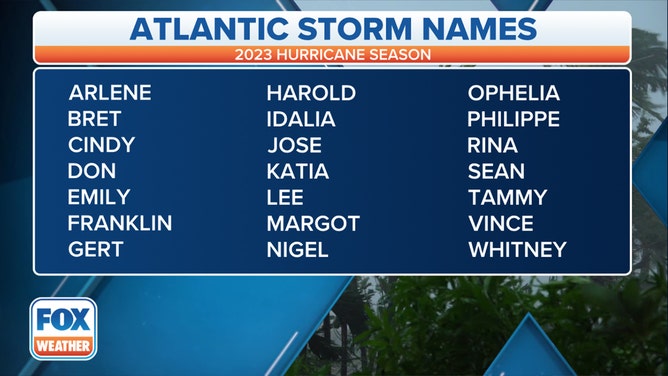
If a tropical storm does develop, it will be named Bret.
The odds seem to favor it turning north before reaching the islands, especially if it gets fairly strong, but it’s too soon to be sure.
Nothing else appears imminent, but the super-warm ocean adds an unwelcome wrinkle to the predicting what to expect early in the season based on what’s happened in the past.

Here is the list of names for the 2023 Atlantic hurricane season.
(FOX Weather)
