Watch: Hurricane Ernesto’s swell causes North Carolina house to collapse into ocean
Hurricane Ernesto was more than 1,000 miles away from the Tar Heel State when the collapse happened. The National Weather Service office in Morehead City, North Carolina, issued a Coastal Flood Advisory and a High Surf Advisory for many coastal areas because the combination of the hurricane and high tide created by the supermoon.

VIDEO: North Carolina home collapses into ocean during Ernesto
Video taken Friday from North Carolina’s Outer Banks showed a house falling into the Atlantic Ocean. Scenes of unoccupied homes collapsing have become a common sight along the coastline due to severe erosion. (Chicamacomico Banks Fire & Rescue)
RODANTHE, N.C. – Swells produced by Hurricane Ernesto led to at least one house collapsing along North Carolina’s Outer Banks Friday, with the threat of problems caused by high ocean levels expected to continue into next week.
Dare County Emergency Management reported the house was unoccupied and was already at risk of collapsing well before the hurricane’s tides did the weakened structure in.
Debris was said to be moving northward along the beach, and National Park Service staff at Cape Hatteras National Seashore were monitoring the situation.
![Debris around the Black Pearl in Rodanthe, NC.]() Image 1 of 6
Image 1 of 6Debris around the Black Pearl in Rodanthe, NC. (Chicamacomico Banks Fire & Rescue)
![Exposed underside of a pool in Rodanthe, NC.]() Image 2 of 6
Image 2 of 6Exposed underside of a pool in Rodanthe, NC. (Chicamacomico Banks Fire & Rescue)
![Houses in Rodanthe, NC.]() Image 3 of 6
Image 3 of 6Houses in Rodanthe, NC. (Chicamacomico Banks Fire & Rescue)
![Houses in Rodanthe, NC.]() Image 4 of 6
Image 4 of 6Houses in Rodanthe, NC. (Chicamacomico Banks Fire & Rescue)
![Seagull Street in Rodanthe, NC.]() Image 5 of 6
Image 5 of 6Seagull Street in Rodanthe, NC. (Chicamacomico Banks Fire & Rescue)
![America Drive in Rodanthe, NC.]() Image 6 of 6
Image 6 of 6America Drive in Rodanthe, NC. (Chicamacomico Banks Fire & Rescue)


The Category 2 hurricane was safely more than 1,000 miles away from the Tar Heel State when the event occurred, but due to the combination of rough surf and high water levels, significant erosion and coastal flooding were expected along barrier islands.
Flooding was also reported along North Carolina Highway 12, the main thoroughfare into and out of the islands that make up the Outer Banks.
Photos from Ocracoke Island showed overwash during periods of high tide, but the North Carolina Department of Transportation said the roadway remained open.
DOT crews are continuously monitoring the highway and have placed large sandbags along the route to limit water intrusions.
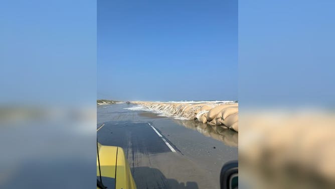
Flooding along SR 12 in the Outer Banks
(FOX Weather)
WATCH: PART OF BUILDING COLLAPSES, WASHES AWAY AFTER BATTERED BY WAVES IN MAINE STORM
The National Weather Service office in Morehead City, North Carolina, has issued a Coastal Flood Advisory and a High Surf Advisory for many coastal communities because of the combination of the hurricane and high tides created by the Moon cycle.
NWS meteorologists warned of inundation levels of 1 to 2 feet that were expected during periods of high tide.
"Up to 1 to 2 feet of inundation above ground level is possible in low-lying areas near shorelines and tidal waterways, resulting in a low threat of property damage. Some roads and low-lying property, including parking lots, parks, lawns, and homes adjacent to the waterfront, may experience shallow flooding," the NWS said.
Most of the eastern seaboard was dealing with similar conditions with higher-than-normal tides, as well as an extreme risk for rip currents.
Rip currents form when water piles up, creating a narrow, fast-flowing stream that swiftly carries swimmers away from shore, often catching beachgoers off guard.
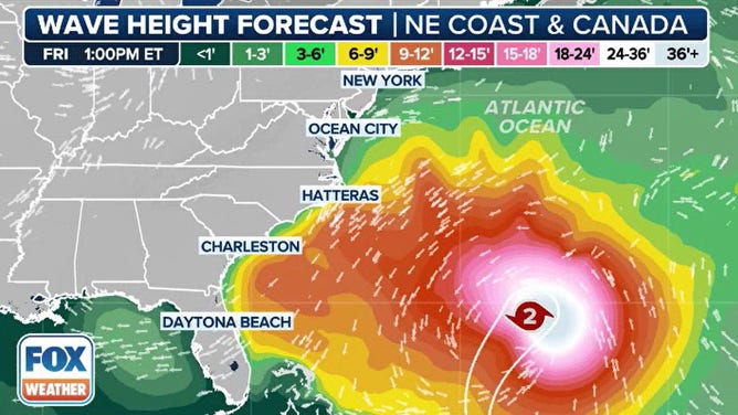
Wave heights created by Hurricane Ernesto
(FOX Weather)
ANGRY ATLANTIC OCEAN SWALLOWS SIXTH HOME ALONG CAPE HATTERAS NATIONAL SEASHORE IN NORTH CAROLINA
More than half a dozen homes have collapsed into the ocean since 2020, according to the NPS.
Staff said the daily effects of wind, waves and tides, along with rising ocean levels, have played a significant role in coastal erosion along Cape Hatteras National Seashore.
Frequently, during significant weather events, parts of beaches around Rodanthe and Buxton are closed due to hazardous debris.
Rough surf can dislodge pipes, wires and expose concrete, creating dangers for beachgoers.
The NPS did not state if any other homes are in immediate danger of collapse, but high water levels are expected to continue for several days as the U.S. East Coast not only sees increased swells from Ernesto but also August’s full supermoon.

Watch: Time lapse video shows collapsed home removed from ocean along North Carolina coast
A time lapse video shows a home that collapsed into the Atlantic Ocean along North Carolina's Cape Hatteras National Seashore and work completed to remove it from the water.