See it: Before-and-after satellite images show deadly reach of historic flooding in Mississippi, Ohio valleys
At least 25 people in seven states have been killed due to the severe weather, including deaths from tornadoes and extreme weather in Tennessee, Missouri, Indiana, Arkansas and Mississippi, and fatalities from flooding in Kentucky.

Historic flooding continues to plague Tennessee communities: ‘Lots of recovery ahead of us’
Communities across the Mississippi and Ohio valleys are continuing to deal with historic and deadly flooding after a nearly two-week stretch of severe weather. Darone Jones, Meteorologist-In-Charge at the National Weather Service office in Memphis, joined FOX Weather on Tuesday morning to break down the current situation in the region.
Communities across the Mississippi and Ohio valleys are continuing to experience catastrophic and deadly flooding in the wake of a nearly two-week-long stretch of extreme weather from the Midwest to the Southeast, and dramatic satellite images are providing a different look at just how expansive the disaster is.
The Cooperative Institute for Research in the Atmosphere (CIRA) at Colorado State University (CSU) shared the before-and-after images on social media late Monday afternoon.
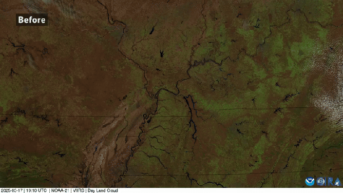
This animated image provides a before-and-after look at the devastating and deadly flooding in the Mississippi and Ohio valleys in April 2025.
(@CIRA_CSU/X / NOAA)
The first image was taken back on March 17 and shows portions of Missouri, Illinois, Indiana, Kentucky, Tennessee and Arkansas still barren as the Northern Hemisphere began its transition from winter to spring.
The image then transitions to what it looked like on Monday, April 7.
You can see how many rivers and streams across the region simply could not hold any additional water and began to spill out of their banks, flooding several cities and towns, including Memphis, Tennessee.
DOWNLOAD THE FREE FOX WEATHER APP

Massive tornado spotted in Arkansas
FOX Weather exclusive Storm Tracker Brandon Copic captured video of a monstrous tornado on the ground near Lake City, Arkansas, on Wednesday.
At least 25 people in seven states have been killed due to the severe weather, including deaths from tornadoes and extreme weather in Tennessee, Missouri, Indiana, Arkansas and Mississippi, and fatalities from flooding in Kentucky.
One of those monster tornadoes was captured live on FOX Weather on Wednesday, April 2, by FOX Weather Exclusive Storm Tracker Brandon Copic.
That tornado that touched down in northwestern Arkansas prompted forecasters to issue a rare Tornado Emergency as the supercell thunderstorm passed through communities such as Lake City and Blytheville.