Historic winter storm causes major power outages, cancels thousands of flights as 245M hunker down nationwide
Travel has already slowed to a crawl, with nearly 10,000 flights canceled nationwide through Monday. Meanwhile, power outages have started to mount across East Texas and Louisiana, where tens of thousands of customers are without power, with the worst of the storm still to come.

Historic winter storm blasts Plains, 245M across 40 states brace for major disruptions
A high-impact and potentially historic winter storm is underway, expected to deliver heavy snow, crippling ice, and days of life-threatening travel conditions to more than 245 million people from Arizona to Maine through the weekend.
A high-impact and potentially historic winter storm is underway, delivering heavy snow, crippling ice and days of life-threatening travel conditions to more than 245 million people from Arizona to Maine through the weekend.
LIVE UPDATES: MILLIONS UNDER ALERT AS HISTORIC WINTER STORM CHARGES ACROSS AMERICA
All told, the storm will stretch across a 2,300-mile path covering more than 40 states from the Southwest into New England, delivering a blend of harsh winter weather impacts.
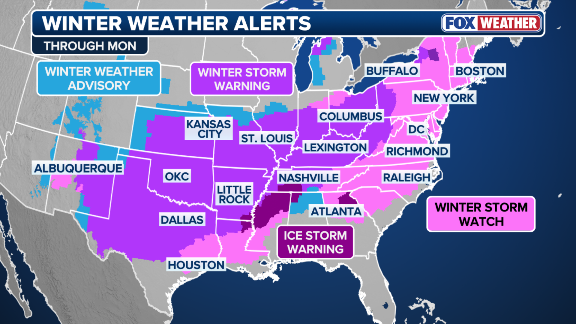
More than 190 million Americans are under Winter Weather Alerts.
Travel has already slowed to a crawl across major transportation hubs, with nearly 15,000 flights canceled nationwide through Monday.
WHAT IS A WINTER STORM WARNING?
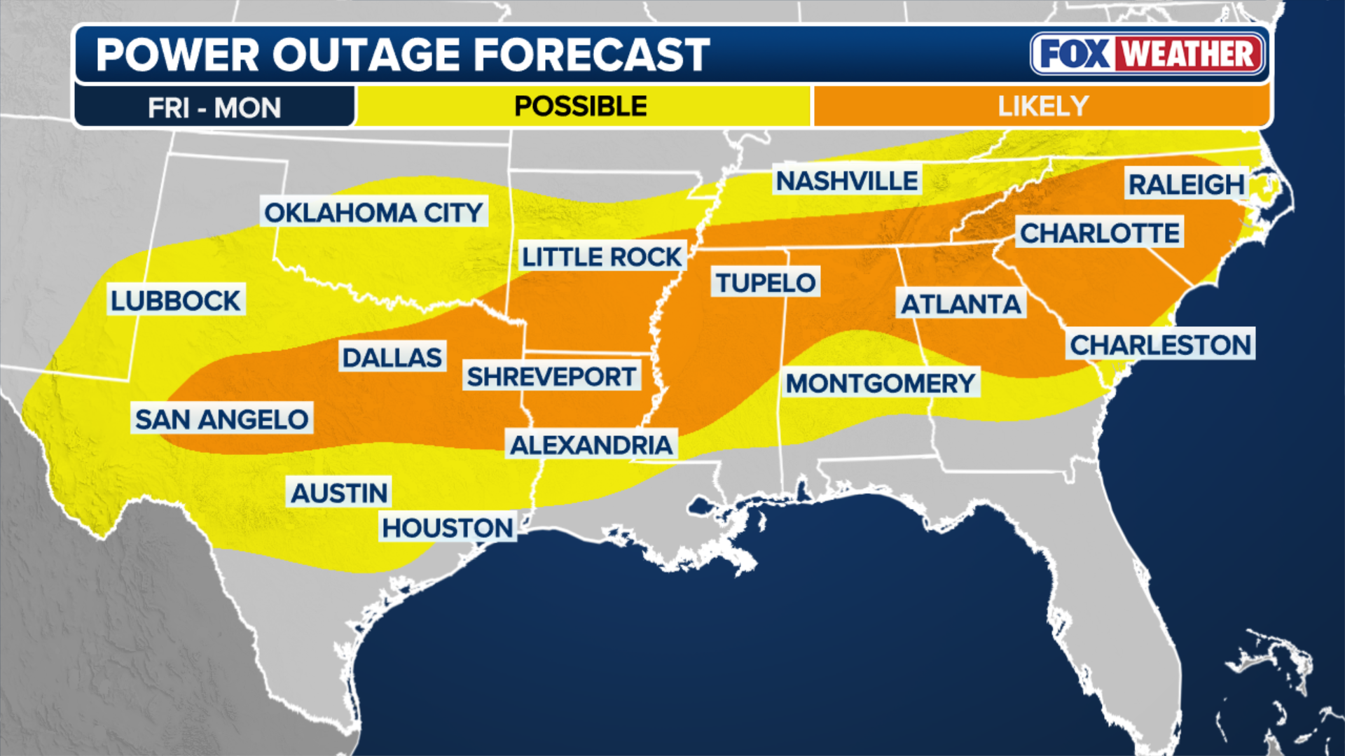
Meanwhile, power outages have started to mount across Louisiana and Mississippi, where hundreds of thousands of customers are without power, with the worst of the storm underway.
The sprawling system has already reached parts of the East Coast, including the Carolinas and Washington, D.C.
(FOX Weather)
States of emergency have already been declared in 21 states, including Arkansas, Louisiana, Mississippi, Alabama, Tennessee, Georgia, South Carolina, North Carolina, Missouri, Kansas, Kentucky, West Virginia, Ohio, Virginia, Maryland, Delaware, Pennsylvania, New York, New Jersey, Indiana, Connecticut and Washington, D.C.
President Donald Trump said on social media that the Trump administration is coordinating with both state and local officials ahead of the winter storm and that the Federal Emergency Management Agency (FEMA) is fully prepared to respond.
(FOX Weather)
The storm had already made history before any flakes flew on Friday, breaking the record for the highest number of counties simultaneously under a Winter Storm Warning.
Formation of the storm
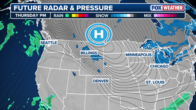
The sprawling system began to develop midday Friday in the Plains, arriving a little before computer forecast models, and started dumping snow, ice and rain as it began its journey across the country.

(FOX Weather)
Bradford and Alamo, Tennessee, recorded 5 inches of snow, whereas Benton, Kentucky, received 4.5 inches so far.

This graphic shows the top snowfall totals recorded in the past 24 hours across the U.S.
(FOX Weather / FOX Weather)
Hays, Kansas recorded 6 inches of snow as of early Saturday morning, while 3 inches was tallied in Norman, Oklahoma over that same period. Heavy snow continued between Interstates 70 and 40 in the Plains on Saturday.
Three cities set new daily records for snow totals, including Paducah, Kentucky, with 4.6 inches, Oklahoma City, Oklahoma, with 4.4 inches, and Kansas City, Kansas, with 5.2 inches, according to the FOX Forecast Center.
(FOX Weather)
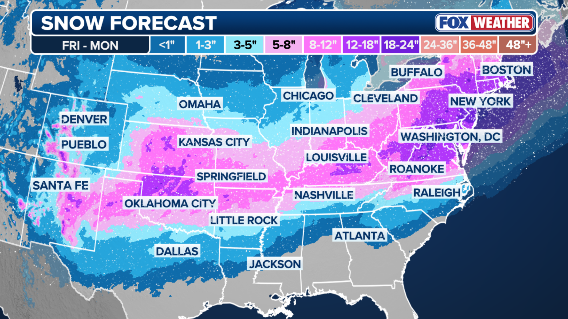
Models continue to put the heaviest snow from just north of Oklahoma City into portions of central Kansas where over a foot of snow is possible. Elsewhere, a wide swath of 5 to 8 inches of snow looks likely to occur, especially in areas from Amarillo north into Kansas City.
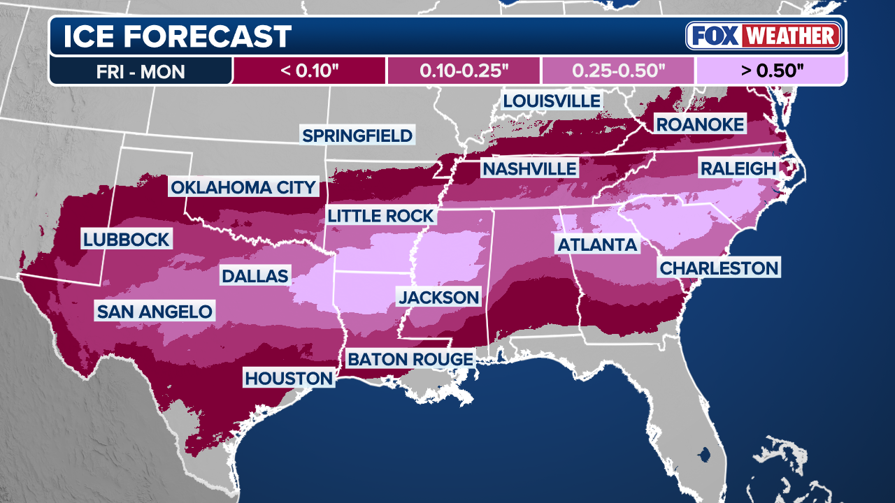
Widespread icing from Midland, Texas, to Dallas and Little Rock is likely throughout most of Saturday, sufficient to cause numerous power outages and severely disrupt travel along major interstates such as I-20 and I-35 into Sunday.
(FOX Weather)
Into the Southeast
The high-impact storm is moving through the Southeast, kicking off the weekend with crippling ice and snow for millions. From Mississippi into parts of the Carolinas, power outages grew as Ice Storm Warnings are scattered across the region.
WHAT IS AN ICE STORM AND WHY ARE THEY SO DANGEROUS?
(FOX Weather)
Within the affected regions, ice accumulation is expected to cause crippling impacts on both power infrastructure and travel. Widespread power outages are likely as the weight of the ice compromises lines and topples trees.

This graphic shows what different amounts of ice accretion can do.
(FOX Weather / FOX Weather)
The highest snow totals in the Southeast are confined to areas along and north of I-40, mainly across Kentucky, which is expected to see significant snow statewide, with totals of 5 to 8 inches. An impressive swath amounting to up to a foot of snow, stretching from border to border, is possible.
HOW TO WATCH FOX WEATHER ON ANY DEVICE FOR FREE
Nashville remains on the edge of the transition zone and could see all snow, a wintry mix or rain.
The higher elevations of middle Tennessee, into east Tennessee and the Smoky Mountains will still see snow totals on the higher end with 3 to 5 inches possible.

Philadelphia grocery shoppers face long lines ahead of winter storm
Grocery shoppers in Philadelphia formed long lines out the door as the region braces for a major winter storm. The National Weather Service issued a Winter Storm Warning for the area starting Saturday night.
Major city snow
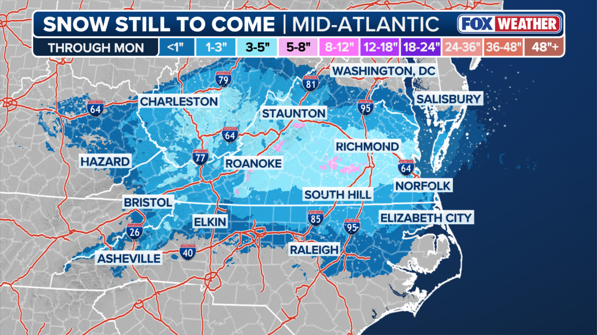
It has been a decade since a foot or more of snow fell in cities like Washington, D.C., Baltimore and Philadelphia, and five years since New York City saw more than a foot. They're streaks that could be coming to an end as this historic storm has its sights on bringing major snow across the Mid-Atlantic, Northeast and the I-95 corridor starting Saturday as the storm moves in from the west.
WHAT DOES A WINTER STORM WARNING MEAN FOR ME?
As the sun rises Sunday morning, snow will be falling from northern Virginia into the New York tri-state area, and it will continue to dump snow and strengthen through the day Sunday, with peak snow rates potentially reaching 2 to 3 inches per hour.
The best chance of the heaviest accumulations are north and west of D.C. along I-81 through Pennsylvania, across I-80 into the tri-State area including New York City, northward into the Hudson Valley, spreading east across southern New England into Boston, where 18 to 24 inches of snow is possible.
(FOX Weather)
As heavy snow chances of over a foot have decreased in Roanoke, Richmond, Washington, D.C., and Philadelphia, current forecasts favor New York City, where 8 to 12 inches of snow is possible.
Another region that could see the "jackpot" in terms of snow totals will be coastal Massachusetts, banking on ocean enhancement of snow bands.
Heavy snow looks likely to set up from the North Shore of Massachusetts and extend down into the northern Cape. A widespread 12 to 18 inches of snow is likely with locally higher amounts possibly closer to two feet.

National Oceanic and Atmospheric Administration Hurricane Hunters fly into historic major winter storm
National Oceanic and Atmospheric Administration Hurricane Hunters flew into the historic winter storm to gather essential statistics and data that weather forecasters use to predict the track of the storm that will bring winter weather impacts to more than 245 million Americans this weeked.
Preparations underway
Ahead of the storm, Americans across the country have prepared for the major storms by raiding local supermarkets as heavy snow and ice accretion make for dangerous travel conditions. Shelves were empty in grocery stores from Texas to New York.
![]() Image 1 of 9
Image 1 of 9WASHINGTON, DC, UNITED STATES - JANUARY 23: People shop at a supermarket as shelves are left empty ahead of expected heavy snowfall and freezing temperatures in Washington, DC, on January 23, 2026. (Photo by Celal Gunes/Anadolu via Getty Images)
![]() Image 2 of 9
Image 2 of 9LOUISVILLE, KENTUCKY - JANUARY 23: An employee restocks a shelf with snow shovels at Keith's Hardware store on January 23, 2026 in Louisville, Kentucky. (Photo by Jon Cherry/Getty Images)
![]() Image 3 of 9
Image 3 of 9WASHINGTON, DC - JANUARY 23: Empty bread shelves at a grocery store on January 23, 2026 in Washington, DC. A massive winter storm is bringing frigid temperatures, ice, and snow to nearly 200 million Americans. (Photo by Al Drago/Getty Images)
![]() Image 4 of 9
Image 4 of 9LOUISVILLE, KENTUCKY - JANUARY 23: A sign denoting the stock of de-icing salt is seen at Keith's Hardware store on January 23, 2026 in Louisville, Kentucky. (Photo by Jon Cherry/Getty Images)
![]() Image 5 of 9
Image 5 of 9LOUISVILLE, KENTUCKY - JANUARY 23: Containers of de-icing windshield wash fluid are seen on partially empty shelves at a hardware store on January 23, 2026 in Louisville, Kentucky. (Photo by Jon Cherry/Getty Images)
![]() Image 6 of 9
Image 6 of 9Shoppers cleaned out ground beef at a Whole Foods in Brooklyn, New York on Jan. 23. ( )
![]() Image 7 of 9
Image 7 of 9Near empty pasta shelves are seen as residents stock up on supplies ahead of a cold front expected in the area in Washington, DC, on January 23, 2026. (Photo by Brendan SMIALOWSKI / AFP via Getty Images)
![]() Image 8 of 9
Image 8 of 9WASHINGTON, DC - JANUARY 23: Empty egg shelves at a grocery store on January 23, 2026 in Washington, DC. (Photo by Al Drago/Getty Images)
![]() Image 9 of 9
Image 9 of 9Shoppers pass empty shelves at the Kroger in Brentwood, Tenn., on January 23, 2026. (Photo by Camden Hall/NurPhoto via Getty Images)


Energy companies have already begun mobilizing additional crews to prepare for ice accretion, known to be capable of taking down power lines and creating impossible driving conditions.
HOW MUCH ICE IS NEEDED TO KNOCK OUT POWER, DAMAGE TREES?

Texas DOT prepares for major winter storm
PREPARATIONS UNDERWAY: Ahead of the potentially historic winter storm, Tennessee Department of Transportation crews are making sure their equipment is ready for anything. TDOT will be pretreating the roads throughout the day Thursday. Stay with FOX Weather for the latest:
Frigid temperatures lock in winter weather impact
While current forecasts suggest that the storm will wind down Monday from west to east as the area of low pressure pulls away from the coast, the cold weather will stick around for millions of Americans, prolonging impacts for areas affected by ice and snow.
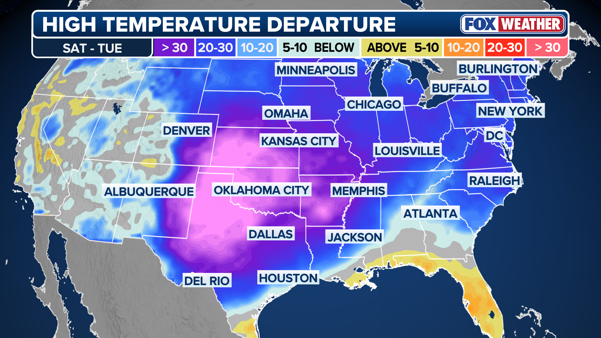
A powerful arctic high is driving exceptionally dense, bitterly cold air deep into the Lower 48. This arctic air mass will then dominate the entire weather pattern through the weekend and will play a key role in the development of the historic winter storm across the South and the East Coast.
(FOX Weather)
Extreme Cold Warnings and watches now extend across much of the Upper Midwest, Plains and into the Northeast.
Major cities included in these alerts range from Minneapolis and Detroit to Boston and New York City. Farther south, locations such as Oklahoma City, Dallas and Little Rock are also under Cold Weather Alerts through the weekend.
Along the East Coast, temperatures will struggle to rise above freezing through the weekend. Cities such as New York City may see highs only in the teens by Sunday, with wind chills making it feel closer to the single digits as more than 260 million Americans will experience below-average temperatures, and over 50 million could see readings drop below zero.
Parlayed with the threat of power outages, frigid temperatures are yet another factor in the multi-threat storm that people should be aware of as the storm unfolds in the coming days.