See incredible video from inside Hurricane Ernesto
The first major hurricane a drone passed through was Hurricane Sam in 2021, which was a powerful Category 4 storm southeast of Bermuda. Saildrone Explorer SD 1045 battled 50-foot waves and winds of over 120 mph to collect the data.

Saildrone captures stunning images inside Hurricane Ernesto
Saildrones have been used to gather data from inside ocean storms. Saildrone Explorer SD 1045, which passed through Hurricane Ernesto, braved 30-foot waves and strong winds to collect data. Brian Connon, vice president of Saildrone's Ocean Mapping, is joining FOX Weather to provide more information about the work being done by these unmanned vehicles.
Drones intentionally steered into the heart of Hurricane Ernesto captured images of massive waves and blustery winds southwest of Bermuda as the cyclone reached its peak intensity in the western Atlantic.
Saildrone Inc., a California-based maritime data company, released video Friday it said was taken more than 100 miles away from Bermuda.

Video from inside Hurricane Ernesto
A set of Saildrones intercepted Hurricane Ernesto while it was a Category 2 hurricane in the southwest Atlantic.
At the time, Ernesto was a Category 2 hurricane on the Saffir-Simpson Hurricane Wind Scale, having previously impacted islands in the northern Caribbean.
The drones recorded wind gusts of up to 94 mph and seas of 20-30 feet.
Video from inside the storm showed enormous white caps as the more than 20-foot-tall vehicles slowly maneuvered through the Atlantic.
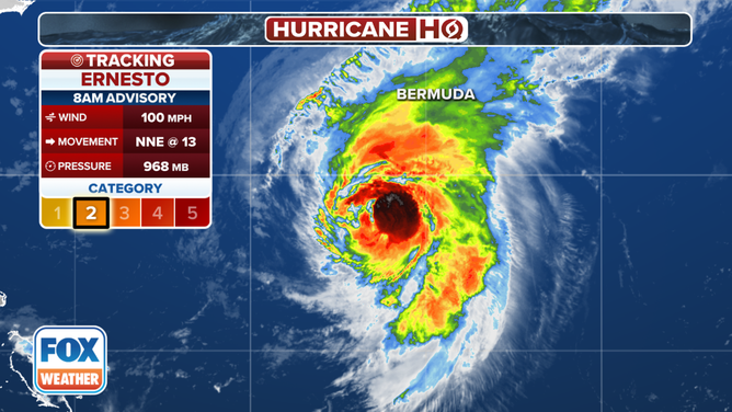
Tracking Hurricane Ernesto.
(FOX Weather)
WATCH: HURRICANE ERNESTO’S SWELL CAUSES NORTH CAROLINA HOUSE TO COLLAPSE INTO OCEAN
Ernesto was not the first intercept of the season, with the company previously announcing ventures into Hurricanes Beryl and Debby.
Operators reported encountering seas of 25 feet and winds greater than 60 mph during their research on Hurricane Beryl in the Caribbean.
The first major hurricane that a Saildrone ever passed through was Hurricane Sam in 2021. The Category 4 hurricane formed off the coast of Africa, and during its closest pass to Bermuda, was intercepted by a vehicle. At the time, the company reported that its drone battled 50-foot waves and winds of over 120 mph.
The Guinness World Records later certified that the drone documented the highest wind speed ever recorded by an uncrewed surface vehicle at 126.4 mph.
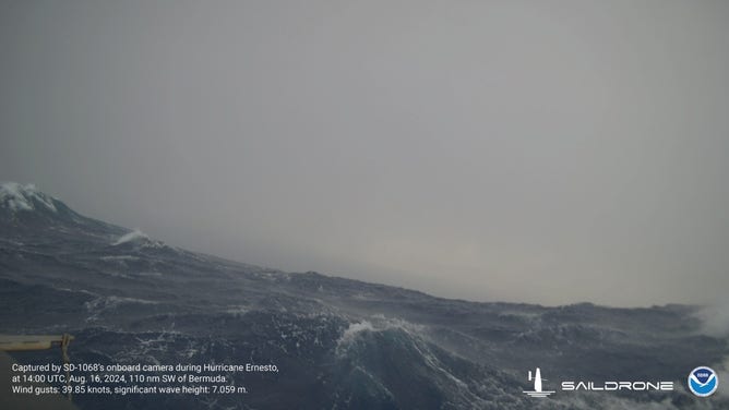
Seas measured 20-30 feet about 130 miles southwest of Bermuda
(Saildrone/NOAA / FOX Weather)
SAILDRONE CAPTURES VIDEO OF HURRICANE BERYL’S FURY IN CARIBBEAN
The giant floating weather stations are remote-controlled and built to withstand the worst impacts from Mother Nature.
Data collected during storms is intended to assist forecasters in making more accurate predictions, particularly regarding intensity fluctuations.
NOAA contends that, over the past several decades, the accuracy of hurricane tracks has outpaced intensity forecasts, which could be related to warming oceans and subtle ocean currents.
The company has deployed at least a dozen drones across half a dozen areas of operation in the Atlantic, Caribbean and Gulf of Mexico.
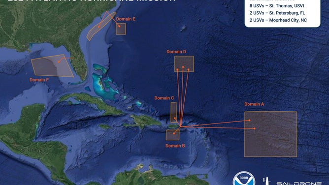
Saildrone, Inc. coverage map 2024