Watch: Hurricane Francine's fury slams Louisiana with ferocious wind, torrential rain
Scenes across southern Louisiana showed the power of Hurricane Francine's 100-mph winds and storm surge along coastal areas. Francine made landfall on Wednesday in Terrebonne Parish as a Category 2 hurricane.

Winds whip in Theriot, Louisiana, as Francine's eye wall moves through
FOX Weather's Mike Seidel is in Theriot, Louisiana, as winds from Francine's eye wall tear through the city.
Hurricane Francine's fury was felt across southern Louisiana on Wednesday, even before the Category 2 hurricane made landfall more than an hour southwest of New Orleans.
Francine made landfall in Terrebonne Parish at 5 p.m., bringing 100-mph winds to the marshes of Louisiana. Nearly all of Assumption and Terrebonne parishes were without power, as outages across the Bayou State climbed above 200,000 about three hours after landfall and eventually reached 400,000 outages by Thursday morning.
Communities in Terrebonne Parish, including Dulac, Houma, Theriot and Chauvin, saw devastating storm surge and wind damage.
![A fallen tree blocks an intersection on September 11, 2024 in Houma, Louisiana.]() Image 1 of 8
Image 1 of 8A fallen tree blocks an intersection on September 11, 2024 in Houma, Louisiana. (Brandon Bell)
![A member of the Brown family stands on a corner while waiting for law enforcement after their power went down in the Polk Street neighborhood on September 11, 2024 in Houma, Louisiana.]() Image 2 of 8
Image 2 of 8A member of the Brown family stands on a corner while waiting for law enforcement after their power went down in the Polk Street neighborhood on September 11, 2024 in Houma, Louisiana. (Brandon Bell)
![A fire hydrant is seen in floodwater during Hurricane Francine on September 11, 2024 in Dulac, Louisiana.]() Image 3 of 8
Image 3 of 8A fire hydrant is seen in floodwater during Hurricane Francine on September 11, 2024 in Dulac, Louisiana. (Brandon Bell)
![A road is blocked off ahead of Hurricane Francine's arrival on September 11, 2024 in Dulac, Louisiana.]() Image 4 of 8
Image 4 of 8A road is blocked off ahead of Hurricane Francine's arrival on September 11, 2024 in Dulac, Louisiana. (Brandon Bell)
![Floodwater fills a neighborhood during Hurricane Francine on September 11, 2024 in Dulac, Louisiana.]() Image 5 of 8
Image 5 of 8Floodwater fills a neighborhood during Hurricane Francine on September 11, 2024 in Dulac, Louisiana. (Brandon Bell)
![A first responder drives through town after the power went down on September 11, 2024 in Houma, Louisiana.]() Image 6 of 8
Image 6 of 8A first responder drives through town after the power went down on September 11, 2024 in Houma, Louisiana. (Brandon Bell)
![Signage is strewn across the intersection after Hurricane Francine swept through the area on September 11, 2024 in Houma, Louisiana.]() Image 7 of 8
Image 7 of 8Signage is strewn across the intersection after Hurricane Francine swept through the area on September 11, 2024 in Houma, Louisiana. (Brandon Bell)
![First Responders with the Coteau Fire District clear hanging tree branches after Hurricane Francine swept through the area on September 11, 2024 in Houma, Louisiana.]() Image 8 of 8
Image 8 of 8First Responders with the Coteau Fire District clear hanging tree branches after Hurricane Francine swept through the area on September 11, 2024 in Houma, Louisiana. (Brandon Bell)


Dulac recorded a 90-mph wind gust after landfall. The video recorded below shows the dangerous storm surge flooding created by Francine.

Shrimp boat battles relentless waves from Francine in Dulac, Louisiana
Witness the terrifying power of nature as a shrimp boat battles the relentless waves and howling winds of Hurricane Francine in Dulac, Louisiana.
The owners of the CoCo Marina in Chauvin were asking for prayers as Francine brought a devastating storm surge that covered the docks.
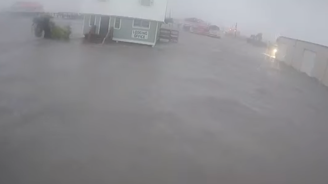
Storm surge from Hurricane Francine seen on security video at CoCo Marina in Chauvin, Louisiana on Sept. 11, 2024.
(CoCo Marina)
Storm chasers code: Always have a chainsaw
FOX Weather Storm Chaser Brandon Copic says he never covers a storm without the proper equipment, including a chainsaw. That came in handy after Francine's powerful winds knocked down a large tree in Houma, blocking a road. He and the other storm chasers quickly cut up the tree to clear the road.
"Most of the time it's just clearing one lane, so emergency responders can get in and out," Copic said.
Copic's truck suffered damage from a rapid wind shift as the eyewall approached the coast, causing a spinup.
"There was a tree behind me. It literally blew that tree apart and blew the tree into my Tahoe and broke my back taillight and busted out my back window," Copic said.
The veteran storm chaser recorded the video below showing the powerful winds from Francine ripping a building apart in minutes.

Hurricane Francine's winds rip down building in Houma, Louisiana
FOX Weather Storm Chaser Brandon Copic was in Houma, Louisiana after Hurricane Francine's landfall when near 100 mph winds ripped apart a building.
FOX Weather Correspondent Robert Ray was also reporting from Houma for landfall as winds continued to blow trees, street signs and roof debris around. Ray dodged a direct hit from a street sign in the video below during a live shot covering the storm.

Hurricane debris whips past reporter during live coverage of Francine in Louisiana
FOX Weather's Robert Ray was in Houma, Louisiana, when Hurricane Francine made landfall Wednesday afternoon. Debris can be seen blowing past Ray during live coverage.
FOX Weather Storm Specialist Mike Seidel was in Theriot where powerful gusting winds from Francine can be seen in the video below.
Large branches and debris littered U.S. Highway 90 east of Morgan City on Wednesday night as Seidel and his crew made their way back through Francine's eyewall.
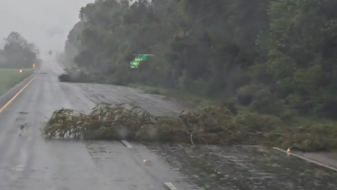
Downed trees and branches on US. Highway 90 near Morgan City, Louisiana on Sept. 11, 2024.
(Mike Seidel/FOX Weather)
Francine's impacts in New Orleans included heavy rain. As the storm moved farther inland, tropical downpours moved in, prompting a Flash Flood Emergency.
FOX Weather Meteorologist Bob Van Dillien was on Bourbon Street and said hurricane parties continued even as the winds picked up. Conditions quickly began to deteriorate into Wednesday night as rainfall rates reached 6-plus inches per hour, measuring a half-inch in just 9 minutes.
New Orleans International Airport officially had its second-wettest September day on record Wednesday with 7.33 inches. It was also the city's ninth-wettest day overall since 1946.

Bourbon Street sees intense rainfall from Hurricane Francine
FOX Weather Meteorologist Bob Van Dillien said the pumps in New Orleans are able to keep up with the heavy rainfall from Hurricane Francine preventing major flooding on Bourbon street as rainfall rates reach 2 inches per hour.