Helene's flood scars revealed in Old Fort, Spruce Pine from satellite images over North Carolina
As the communities of Old Fort and Spruce Pine work tirelessly to rebuild their lives, these satellite images provide a visual record of their long journey ahead to recover.
Satellite imagery before and after Hurricane Helene
Satellite images from Maxar Technologies show the extent of flooding in Old Fort and Spruce Pine in western North Carolina.
SPRUCE PINE, N.C. – Skies finally cleared over North Carolina on Wednesday, offering a glimpse of the devastation left behind by Hurricane Helene.
It’s been one week since Helene made landfall along the U.S. Gulf Coast, decimating communities across the Southeast and leaving more than 190 people dead across six states. North Carolina has seen the most deaths, with a majority occurring in Buncombe County, particularly in the Asheville area.
President Joe Biden has directed the Department of Defense to deploy 1,000 soldiers to help deliver essential supplies to flood-affected regions.
Maxar Technologies' new satellite imagery painted a stark picture of the storm's wrath. Two towns in the western part of North Carolina, Old Fort and Spruce Pine, bore the brunt of the flooding.
NORTH CAROLINA COMMUNITIES REMAIN ISOLATED ONE WEEK AFTER HELENE MADE DEADLY TREK ACROSS SOUTHEAST
![Maxar collected new satellite imagery on Wednesday that reveals some of the flooding aftermath caused by Hurricane Helene as the storm swept through North Carolina.]() Image 1 of 10
Image 1 of 10Maxar collected new satellite imagery on Wednesday that reveals some of the flooding aftermath caused by Hurricane Helene as the storm swept through North Carolina. (Maxar Technologies)
![Maxar collected new satellite imagery on Wednesday that reveals some of the flooding aftermath caused by Hurricane Helene as the storm swept through North Carolina.]() Image 2 of 10
Image 2 of 10Maxar collected new satellite imagery on Wednesday that reveals some of the flooding aftermath caused by Hurricane Helene as the storm swept through North Carolina. (Maxar Technologies)
![Maxar collected new satellite imagery on Wednesday that reveals some of the flooding aftermath caused by Hurricane Helene as the storm swept through North Carolina.]() Image 3 of 10
Image 3 of 10Maxar collected new satellite imagery on Wednesday that reveals some of the flooding aftermath caused by Hurricane Helene as the storm swept through North Carolina. (Maxar Technologies)
![Maxar collected new satellite imagery on Wednesday that reveals some of the flooding aftermath caused by Hurricane Helene as the storm swept through North Carolina.]() Image 4 of 10
Image 4 of 10Maxar collected new satellite imagery on Wednesday that reveals some of the flooding aftermath caused by Hurricane Helene as the storm swept through North Carolina. (Maxar Technologies)
![Maxar collected new satellite imagery on Wednesday that reveals some of the flooding aftermath caused by Hurricane Helene as the storm swept through North Carolina.]() Image 5 of 10
Image 5 of 10Maxar collected new satellite imagery on Wednesday that reveals some of the flooding aftermath caused by Hurricane Helene as the storm swept through North Carolina. (Maxar Technologies)
![Maxar collected new satellite imagery on Wednesday that reveals some of the flooding aftermath caused by Hurricane Helene as the storm swept through North Carolina.]() Image 6 of 10
Image 6 of 10Maxar collected new satellite imagery on Wednesday that reveals some of the flooding aftermath caused by Hurricane Helene as the storm swept through North Carolina. (Maxar Technologies)
![Maxar collected new satellite imagery on Wednesday that reveals some of the flooding aftermath caused by Hurricane Helene as the storm swept through North Carolina.]() Image 7 of 10
Image 7 of 10Maxar collected new satellite imagery on Wednesday that reveals some of the flooding aftermath caused by Hurricane Helene as the storm swept through North Carolina. (Maxar Technologies)
![Maxar collected new satellite imagery on Wednesday that reveals some of the flooding aftermath caused by Hurricane Helene as the storm swept through North Carolina.]() Image 8 of 10
Image 8 of 10Maxar collected new satellite imagery on Wednesday that reveals some of the flooding aftermath caused by Hurricane Helene as the storm swept through North Carolina. (Maxar Technologies)
![Maxar collected new satellite imagery on Wednesday that reveals some of the flooding aftermath caused by Hurricane Helene as the storm swept through North Carolina.]() Image 9 of 10
Image 9 of 10Maxar collected new satellite imagery on Wednesday that reveals some of the flooding aftermath caused by Hurricane Helene as the storm swept through North Carolina. (Maxar Technologies)
![Maxar collected new satellite imagery on Wednesday that reveals some of the flooding aftermath caused by Hurricane Helene as the storm swept through North Carolina.]() Image 10 of 10
Image 10 of 10Maxar collected new satellite imagery on Wednesday that reveals some of the flooding aftermath caused by Hurricane Helene as the storm swept through North Carolina. (Maxar Technologies)


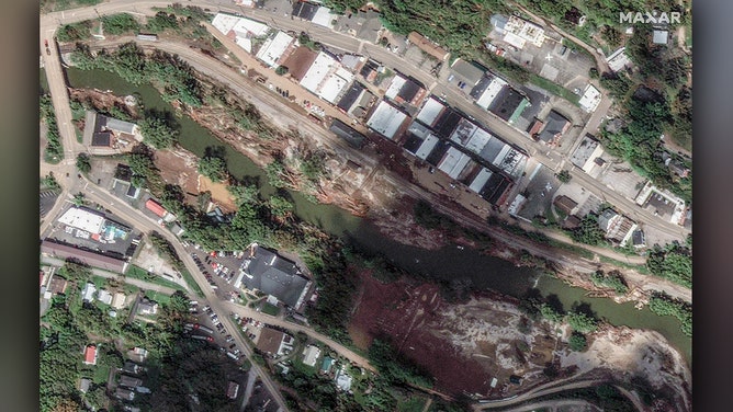
The before-and-after images tell a story of transformation, as lush green landscapes are now dotted with patches of brown where floodwaters have receded.

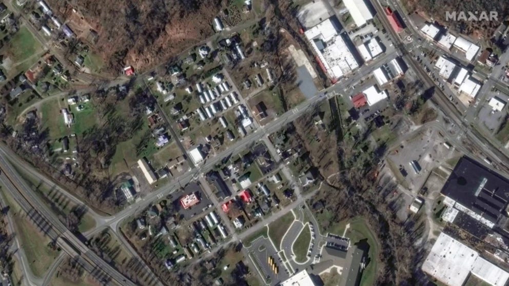
A look at Old Fort, North Carolina, before Helene on Jan. 7, 2022.
(Maxar Technologies)
In Old Fort, a once-vibrant town, is now seen submerged beneath murky waters.

A look at Old Fort, North Carolina, after Helene on Oct. 2, 2024.
(Maxar Technologies)
The same could be seen in Spruce Pine along the North Toe River near the town's water treatment plant.

A look at Spruce Pine, North Carolina, before Helene on Feb. 3, 2024.
(Maxar Technologies)

A look at Spruce Pine, North Carolina, after Helene on Oct. 2, 2024
(Maxar Technologies)
Maxar's team says they continue to monitor the region, gathering new data to assess the extent of the damage and provide crucial information for recovery efforts.