Satellite images reveal scope of destruction from Burma’s devastating earthquake
“Supply infrastructure and communication towers were severely impacted, electricity and water services were disrupted, including in Yangon Region. Landline, mobile and internet networks remain unstable. Damage to the Yangon-Nay Pyi Taw-Mandalay expressway led to service disruptions, with cracks and surface distortions, forcing highway buses to halt operations," the United Nation’s Office for the Coordination of Humanitarian Affairs said in a preliminary report.
Maxar satellite imagery of devastating earthquake in Southeast Asia
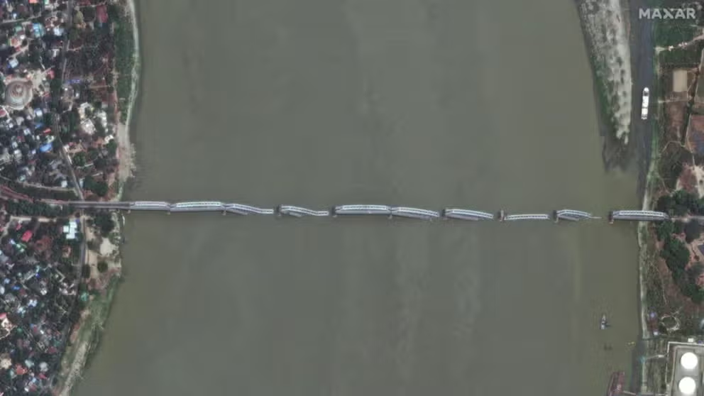
Before-and-after satellite imagery is revealing the widespread destruction caused by a powerful 7.7-magnitude earthquake, which is believed to have killed thousands across Myanmar and neighboring Thailand. (Satellite image ©2025 Maxar Technologies)
Before-and-after satellite imagery is revealing the widespread destruction caused by a powerful 7.7-magnitude earthquake, which is believed to have killed thousands across Burma and neighboring Thailand.
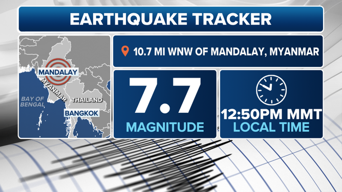
The quake, which struck near Mandalay, Burma’s second-largest city, on Friday, was felt hundreds of miles away and impacted tens of millions of residents throughout Southeast Asia.
Satellite imagery from Maxar Technologies, a Colorado-based company, showed the devastation, with homes destroyed, bridges collapsed and religious sites turned into ruins.
According to estimates from the United States Geological Survey, the event marked the most destructive earthquake in Burma in over 100 years and the deadliest since a series of earthquakes struck Syria and Turkey in 2023, killing at least 150,000.
Myanmar earthquake tracker
(FOX Weather)
BANGKOK SKYSCRAPER COLLAPSES DURING 7.7 EARTHQUAKE
Search and rescue efforts were launched immediately after the earthquake, but authorities have reported slowdowns due to damaged infrastructure.
"Supply infrastructure and communication towers were severely impacted, electricity and water services were disrupted, including in the Yangon Region. Landline, mobile, and internet networks remain unstable. Damage to the Yangon-Nay Pyi Taw-Mandalay expressway caused service disruptions, with cracks and surface distortions halting highway buses," the United Nations’ Office for the Coordination of Humanitarian Affairs said in a preliminary report.
Countries and organizations, including the European Union and Malaysia, have pledged support for the affected region, with search teams from China and India already on the ground, searching for victims trapped in the debris.
Seismologists noted that the region’s soft soil likely amplified the effects of the seismic waves, making structures particularly vulnerable along the Sagaing Fault.
While Burma has experienced earthquakes in the past, the recent 7.7-magnitude quake is the greatest event in recent history.
Potentially complicating relief efforts are ongoing internal hostilities, which showed few signs of abating in the days after the natural disaster.
![People inspect the debris of a collapsed building in Mandalay on March 28, 2025, after an earthquake. A powerful earthquake killed more than 20 people across Myanmar and Thailand on March 28, toppling buildings and bridges and trapping over 80 workers in an under-construction skyscraper in Bangkok.]() Image 1 of 6
Image 1 of 6People inspect the debris of a collapsed building in Mandalay on March 28, 2025, after an earthquake. A powerful earthquake killed more than 20 people across Burma and Thailand on March 28, toppling buildings and bridges and trapping over 80 workers in an under-construction skyscraper in Bangkok. (Photo by STR/AFP via Getty Images)
![Myanmar, Thailand earthquake]() Image 2 of 6
Image 2 of 6A damaged pagoda is pictured in Mandalay on March 29, 2025, a day after an earthquake struck central Burma. Rescuers dug through the rubble of collapsed buildings on March 29 in a desperate search for survivors after a huge earthquake hit Burma and Thailand, killing more than 150 people. (Photo by SAI AUNG MAIN/AFP via Getty Images)
![Myanmar, Thailand earthquake]() Image 3 of 6
Image 3 of 6TOPSHOT - People drive on a motorbike past a collapsed building in Mandalay on March 28, 2025, after an earthquake in central Burma. A powerful earthquake rocked central Burma on March 28, buckling roads in capital Naypyidaw, damaging buildings and forcing people to flee into the streets in neighbouring Thailand. (Photo by STR/AFP via Getty Images)
![Myanmar, Thailand earthquake]() Image 4 of 6
Image 4 of 6People look on next to a collapsed building in Mandalay on March 28, 2025, after an earthquake in central Burma. A powerful earthquake rocked central Burma on March 28, buckling roads in capital Naypyidaw, damaging buildings and forcing people to flee into the streets in neighbouring Thailand. (Photo by STR/AFP via Getty Images)
![Myanmar, Thailand earthquake]() Image 5 of 6
Image 5 of 6People gather around a collapsed building as heavy construction equipment is used to move the debris in Mandalay on March 28, 2025, after an earthquake in central Myanmar. A powerful earthquake rocked central Burma on March 28, buckling roads in capital Naypyidaw, damaging buildings and forcing people to flee into the streets in neighbouring Thailand (Photo by STR/AFP via Getty Images)
![Myanmar, Thailand earthquake]() Image 6 of 6
Image 6 of 6People stand past the debris of a collapsed building in Mandalay on March 28, 2025, after an earthquake. A powerful earthquake killed more than 20 people across Burma and Thailand on March 28, toppling buildings and bridges and trapping over 80 workers in an under-construction skyscraper in Bangkok. (Photo by STR/AFP via Getty Images)


According to the U.S. State Department, the country of more than 54 million people has been embroiled in a civil war, with various factions controlling certain regions.
"Since the military seized power on February 1, 2021, at least 5,350 civilians have been killed, and more than 3.3 million displaced. Over half the population is living below the poverty line, mainly due to violence perpetrated by the national armed forces," the U.N.’s human rights office previously stated.
Significant damage from the quake was also reported in China and Thailand, where video captured the collapse of a 33-story building under construction in Bangkok, potentially killing dozens of workers.
The region is bracing for weeks of significant aftershocks, though seismologists say the likelihood of a tremor surpassing the intensity of the original quake is extremely low.

Building collapses in Bangkok amid 7.7 earthquake in Asia
A skyscraper under construction collapsed in Bangkok during a 7.7 quake that struck Burma on Friday.