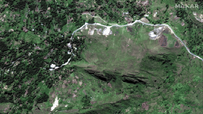
Satellite imagery shows landslide that is believed to have buried thousands in Papua New Guinea
According to a 2021 government estimate, the country had a population of nearly 12 million. Papua New Guinea shares a border with Indonesia and is located north of Australia, both of which have pledged assistance to the disaster.

Over 100 feared dead in Papua New Guinea after landslide buries villages
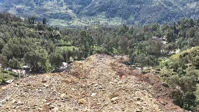
Rescue crews are racing towards Kaokalam, a village about 200 miles north of the capital of Port Moresby in Papua New Guinea. A massive landslide is reported to have buried many residents.
PORT MORESBY, Papua New Guinea – Satellite imagery is revealing the magnitude of a major landslide believed to have buried thousands of people in a remote region of Papua New Guinea, prompting the country to request international assistance.
Maxar, a space technology company based in Colorado, released images Monday of the Enga region, which showed structures buried in mud and debris.
The affected villages lie over 200 miles northwest of the capital, Port Moresby. However, travel to the mountainous region has been hindered by roadways deemed impassable.
Photos showed survivors using sticks and shovels to dig through debris that is estimated to be over 20 feet in some areas.
Initial estimates from the village of Kaokalam put the death toll at around 100, but that figure is believed to have skyrocketed to around 700 and may even go higher, officials warn.
"The United Nations is monitoring the situation closely, in collaboration with national and provincial government authorities, including other partners to determine the extent of damage, casualties and possible assistance that may be necessary for those affected," the United Nations said in a statement.
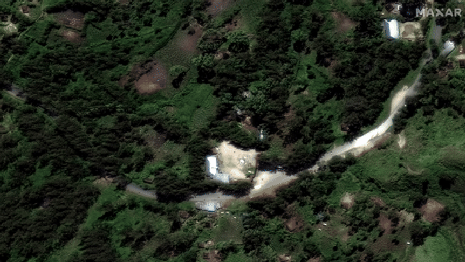
Before and after of Papua New Guinea landslide
(Satellite image ©2024 Maxar Technologies / FOX Weather)
NEARLY 700 VILLAGERS FEARED DEAD AFTER MASSIVE LANDSLIDE BURIES COMMUNITIES IN PAPUA NEW GUINEA
Agency workers say the combination of additional ground movements and an unrelated political conflict are causing slowdowns in relief efforts.
The office of Prime Minister James Marape has not publicly released figures regarding the number of people believed to still be trapped under debris and rubble. However, officials have stated that the hopes of finding survivors are diminishing.
It’s unknown what triggered the landslide, but a series of earthquakes and flooding have impacted the Oceanian country over the last few months.
![Papua New Guinea landslide]() Image 1 of 4
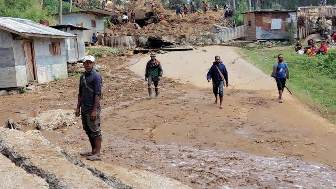
Image 1 of 4Locals are seen near the site of a landslide at Mulitaka village in the region of Maip Mulitaka, in Papua New Guinea's Enga Province on May 26, 2024. More than 670 people are believed dead after a massive landslide in Papua New Guinea, a UN official told AFP on May 26 as aid workers and villagers braved perilous conditions in their desperate search for survivors. (Photo by STR/AFP via Getty Images)
![Papua New Guinea landslide]() Image 2 of 4
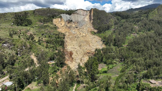
Image 2 of 4This aerial view taken on May 27, 2024 shows a general view of the area affected by a landslide in Yambali village in the region of Maip Mulitaka, in Enga Province, Papua New Guinea. More than 2,000 people are feared buried in a Papua New Guinea landslide that destroyed a remote highland village, the government said on May 27, as it pleaded for international help in the rescue effort. (Photo by Emmanuel ERALIA / AFP) (Photo by EMMANUEL ERALIA/AFP via Getty Images) (Photo by EMMANUEL ERALIA/AFP via Getty Images)
![Papua New Guinea landslide]() Image 3 of 4
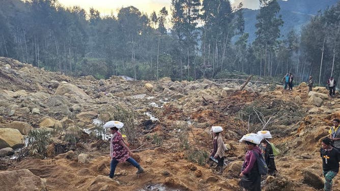
Image 3 of 4ENGA PROVINCE, PAPUA NEW GUINEA - MAY 27: People walk at the destroyed area after a massive landslide struck a village in Enga Province, Papua New Guinea on May 27, 2024. The site's remoteness, ongoing terrain movement and damage to access roads caused relief efforts to slow as government authorities remain focused on clearing debris and improving access to the site. While the exact number of victims is still not known, affected communities estimate that at least 670 people are missing following the landslide, this number is subject to change as rescue efforts are ongoing and expected to continue for days. (Emmanuel Eralia/Anadolu via Getty Images)
![Papua New Guinea landslide]() Image 4 of 4
Image 4 of 4This frame grab from AFPTV video footage taken on May 27, 2024 shows the site of a landslide in Yambali village in the region of Maip Mulitaka, in Enga Province, Papua New Guinea. More than 2,000 people are feared buried in a Papua New Guinea landslide that destroyed a remote highland village, the government said on May 27, as it pleaded for international help in the rescue effort. (Photo by EMMANUEL ERALIA/AFPTV/AFP via Getty Images)
In March, a 6.9-magnitude quake led to the destruction of over 1,000 homes and in April, flooding and landslides caused devastation throughout villages on the island of New Guinea.
The country’s vulnerabilities are exacerbated by its mountainous terrain, which can fail during episodes of earthquakes, torrential rainfall or extreme weather events.
According to government estimates, over 500,000 residents live in the Enga Province, which was already dealing with poor telecommunication and infrastructure before the latest disaster.
"One of the major challenges facing the PNGDF (Papua New Guinea Defence Force) Engineering Team is that the tons of earth and rubble and the surrounding landscape are still unstable, so it is quite dangerous to bring in heavy earth moving equipment. Therefore, the government has requested the support of New Zealand Defense Force Geotechnical Team to assess the stability of the land," the minister of defense said in a statement.
Before and after of Papua New Guinea landslide
(Satellite image ©2024 Maxar Technologies / FOX Weather)