NASA unleashes its science capabilities to aid natural disaster response
NASA said the goal is to offer its full suite of Earth-observing resources to aid disaster response organizations worldwide. A new website features all of NASA's related resources that could be used to respond to flooding, hurricane damage, tornadoes, wildfires, volcanoes and earthquakes.

'I was driving around in a Flash Flood Emergency not knowing about it until I was stuck in it,' said a Miami resident.
Miami resident Gina Chingolani was moving from one apartment to another on Wednesday. She said she had no warning the area was under a Flash Flood Emergency until traffic came to a standstill. It took her 45 minutes to travel a drive that normally takes 7 minutes without flooding.
NASA rolled out a new program to use what it learns from space to help organizations respond to hurricanes, floods, heat waves and other weather-driven events on Earth.
The U.S. space agency continues to use data from its more than a dozen Earth-observing satellites to help government agencies like FEMA respond to disasters, but on Thursday, NASA announced its Disaster Response Coordination System (DRCS), making its resources available in one place for anyone to access.
"The idea is to close that last mile between what we know within the science community and the community of people who can put that science to use to inform decisions they have to make on the ground every day," said Karen St. Germain, NASA Earth Sciences Division director. "Leaders at all levels, from neighborhoods to nations, need actionable information, and they need it where and when they need it."
HEAT KILLS MORE AMERICANS THAN FLOODING, TORNADOES, HURRICANES OR LIGHTNING
NASA's DRCS Manager Joshua Barnes said the goal is to offer its full suite of Earth-observing resources to aid disaster response organizations worldwide.
"This insight can be used to drive resource allocation decisions, take protective actions, and support the staging of disaster relief services, all using Earth Observation sciences," Barnes said.

A before and after image comparing Houston's power outages due to a derecho that struck the city on May 16, 2024.
(NASA)
NASA Administrator Bill Nelson provided examples of recent disasters in which the agency's space data has provided critical information to first responders, including the 1 million power outages in Houston caused by a derecho in May, which happened ahead of a heat wave.
HOUSTON METRO ROCKED BY 100 MPH DERECHO THAT LEFT 7 DEAD AND OVER 1 MILLION WITHOUT POWER
"We've got data we call black marble data, which helps produce images of the Earth at night. And from that data of what the Earth looks like normally with the lights, and then what it looks like after the blackout, we could help first responders size up where they needed to go in the city because of the blackout," Nelson said. "It helped assist people most in need and most at risk."
NASA's Disasters Program was activated in May because of the deadly flooding in Brazil.
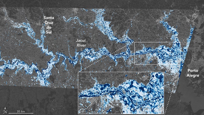
This NASA Earth Observatory map reveals the depth of floodwater that covered Rio Grande do Sul in May 2024.
(NASA)
"We captured from our data not only the extent of the flooding, but also the depths of the waters," Nelson said. "We identified over 3,000 landslides that took place. And that all helped the teams on the ground navigate the situation."
NASA instruments continue documenting the ongoing record-breaking flooding across South Florida this week.
A new website features all of NASA's related resources and data that could be used to map flooding, hurricane damage, tornadoes, wildfires, volcanoes and earthquakes. The website includes a mapping portal with all of NASA's available data about ongoing disasters.
NASA leadership said they hope to hear from disaster response organizations about what they need and with any questions about the space agency's resources.