Community south of Los Angeles sinking towards Pacific Ocean
The Palos Verdes Peninsula is about 25 miles south of downtown Los Angeles and consists of neighborhoods such as San Pedro, Rolling Hills Estates and Rancho Palos Verdes.
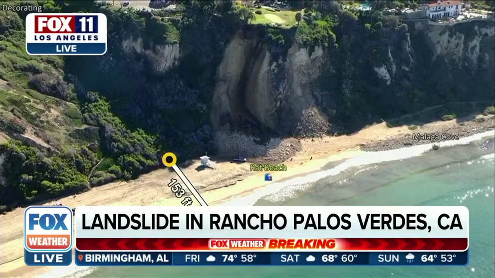
Southern California landslide in Rancho Palos Verdes
FILE - A landslide takes place in Ranchos Palos Verdes, California. A golf course sits on top of the cliff with a small beach underneath it.
RANCHO PALOS VERDES, Calif. – Radar data from NASA shows increasing rates of landslides along the Palos Verdes Peninsula, south of Los Angeles, threatening hundreds of structures.
Data from NASA’s Jet Propulsion Laboratory showed the terrain of the peninsula shifted at a rate of 4 inches per week following periods of heavy rainfall in 2024.
The region, about 25 miles south of downtown Los Angeles, has been home to historic landslides, but weather events after the remnants of Hurricane Hilary in the summer of 2023 impacted the region caused the movement to accelerate. The area was put under a state of emergency in 2024 after record rains then caused some ground to give way.
Some homes have been split in two, while other residents have permanently left the region, fearing additional movement in the terrain.
THESE 7 STATES HOLD THE MOST LANDSLIDE-PRONE COUNTIES IN THE US
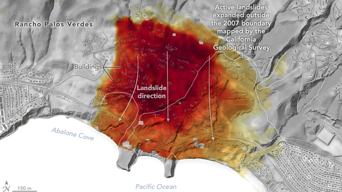
Motion of landslides on the Palos Verdes Peninsula following record-breaking rainfall in 2023.
(NASA)
NASA says it was able to compose a dramatic visualization of the affected region by using its Uninhabited Aerial Vehicle Synthetic Aperture Radar, which is mounted on a Gulfstream III jet.
After a series of passes, specialists were able to compose a map depicting how fast the soil underneath the Palos Verdes Peninsula was moving and highlighted the direction of movement with added arrows.
"In effect, we’re seeing that the footprint of land experiencing significant impacts has expanded, and the speed is more than enough to put human life and infrastructure at risk," Alexander Handwerger, a JPL landslide scientist who performed the analysis, said in a statement.
According to the U.S. Geological Survey, landslides are considered to be a type of "mass wasting," where soil and rocks are at the mercy of gravity.
![Palos Verdes landslide]() Image 1 of 3
Image 1 of 3PALOS VERDES, CA - JUNE 21, 2024 - A section of Exultant and Dauntless Drive is closed due to the ongoing landslide and work to continue to repave the streets and fix the water lines in the Portuguese Bend neighborhood in Palos Verdes on June 21, 2024. According to a resident, two of the homes in the neighborhood have been red tagged. (Genaro Molina/Los Angeles Times via Getty Images)
![Palos Verdes landslide]() Image 2 of 3
Image 2 of 3PALOS VERDES, CA - MAY 29, 2024 - The roads in the Abalone Cove neighborhood continue to sustain damaged by the shifting ground in the Portuguese Bend area of Rancho Palos Verdes on May 29, 2024. Dewatering wells and pumps have been installed in Abalone Cove to divert groundwater which has been cited as a main cause for the shifting ground in the community and causing damage to homes, roads and water lines in Abalone Cove. (Genaro Molina/Los Angeles Times via Getty Images)
![Palos Verdes landslide]() Image 3 of 3
Image 3 of 3PALOS VERDES, CA - MAY 29, 2024 - Abalone Cove community leader Gordon Leon stands near a home that is propped up by metal braces in the Abalone Cove neighborhood in the Portuguese Bend area of Rancho Palos Verdes on May 29, 2024. The resident is still living in the home as the shifting land continues to affect the property. Dewatering wells and pumps have been installed in Abalone Cove to divert groundwater which has been cited as a main cause for the shifting ground in the community and causing damage to homes, roads and water lines in Abalone Cove. (Genaro Molina/Los Angeles Times via Getty Images) (Genaro Molina/Los Angeles Times via Getty Images)


Landslides are typically initiated by rainfall, snowmelt, erosion, earthquakes, volcanic eruptions and human activity.
In the West, Oregon, Washington, California and Idaho have the greatest vulnerabilities from landslides, which cause billions of dollars in damage each year.
The Insurance Information Institute reminds homeowners that, similar to earthquakes, damage from landslides is excluded from standard insurance policies.
As part of the response to the unfolding situation, the City of Rancho Palos Verdes, the Federal Emergency Management Agency, and the California Governor’s Office of Emergency Services announced a $42 million buyout program for property owners in 2024.
"While JPL’s radar imagery strongly visualizes this dramatic acceleration and expansion of the landslide area during September and October 2024, the city would note that the landslide has decelerated since October due to the drier weather conditions and the city’s installation of highly productive deep dewatering wells," the City of Rancho Palos Verdes stated. "The city is hopeful that this trend holds with its dewatering and winterization measures and continues to urge state and federal agencies to financially support these efforts."