Devils Tower slammed by baseball-sized hail, closing the national park
The National Park Service closed Devils Tower for two days due to the storm damage. The park reopened Wednesday afternoon.

'Did it snow here?' Massive hailstorm clobbers Devils Tower National Monument
Devils Tower Trading Post Manager Tom Ferguson describes the hard-hitting hailstorm that broke 21 windows of the Wyoming business and made picnic tables do
DEVILS TOWER, Wyo. – Baseball-sized hail clobbered Devils Tower National Monument on Monday as a powerful supercell storm formed in northeast Wyoming.
The National Weather Service reported significant damage to trees, buildings, campers and vehicles caused by 2.75-inch hail and 54-mph wind. The extreme weather moved directly over the Bear Lodge Ranger District of the Black Hills near Hulett and Sundance in Crook County.
WATCH: SEVERE THUNDERSTORM CAUSES BOUNCE HOUSE TO GO AIRBORNE IN ALABAMA
![Late Monday afternoon, a supercell developed across northeast Wyoming and tracked directly over Devils Tower, Wyoming, where it caused extensive damage to trees, buildings, campers and vehicles.]() Image 1 of 9
Image 1 of 9Late Monday afternoon, a supercell developed across northeast Wyoming and tracked directly over Devils Tower, Wyoming, where it caused extensive damage to trees, buildings, campers and vehicles. (Courtesy of Ken Nutter via NWS)
![Late Monday afternoon, a supercell developed across northeast Wyoming and tracked directly over Devils Tower, Wyoming, where it caused extensive damage to trees, buildings, campers and vehicles.]() Image 2 of 9
Image 2 of 9Late Monday afternoon, a supercell developed across northeast Wyoming and tracked directly over Devils Tower, Wyoming, where it caused extensive damage to trees, buildings, campers and vehicles. (Courtesy of Jodi Havener via NWS)
![Late Monday afternoon, a supercell developed across northeast Wyoming and tracked directly over Devils Tower, Wyoming, where it caused extensive damage to trees, buildings, campers and vehicles.]() Image 3 of 9
Image 3 of 9Late Monday afternoon, a supercell developed across northeast Wyoming and tracked directly over Devils Tower, Wyoming, where it caused extensive damage to trees, buildings, campers and vehicles. (Courtesy of Jodi Havener via NWS)
![Late Monday afternoon, a supercell developed across northeast Wyoming and tracked directly over Devils Tower, Wyoming, where it caused extensive damage to trees, buildings, campers and vehicles.]() Image 4 of 9
Image 4 of 9Late Monday afternoon, a supercell developed across northeast Wyoming and tracked directly over Devils Tower, Wyoming, where it caused extensive damage to trees, buildings, campers and vehicles. (Courtesy of Ken Nutter via NWS)
![Late Monday afternoon, a supercell developed across northeast Wyoming and tracked directly over Devils Tower, Wyoming, where it caused extensive damage to trees, buildings, campers and vehicles.]() Image 5 of 9
Image 5 of 9Late Monday afternoon, a supercell developed across northeast Wyoming and tracked directly over Devils Tower, Wyoming, where it caused extensive damage to trees, buildings, campers and vehicles. (State of Wyoming)
![Late Monday afternoon, a supercell developed across northeast Wyoming and tracked directly over Devils Tower, Wyoming, where it caused extensive damage to trees, buildings, campers and vehicles.]() Image 6 of 9
Image 6 of 9Late Monday afternoon, a supercell developed across northeast Wyoming and tracked directly over Devils Tower, Wyoming, where it caused extensive damage to trees, buildings, campers and vehicles. (Courtesy of Jodi Havener via NWS)
![Late Monday afternoon, a supercell developed across northeast Wyoming and tracked directly over Devils Tower, Wyoming, where it caused extensive damage to trees, buildings, campers and vehicles.]() Image 7 of 9
Image 7 of 9Late Monday afternoon, a supercell developed across northeast Wyoming and tracked directly over Devils Tower, Wyoming, where it caused extensive damage to trees, buildings, campers and vehicles. (Courtesy of Ken Nutter via NWS)
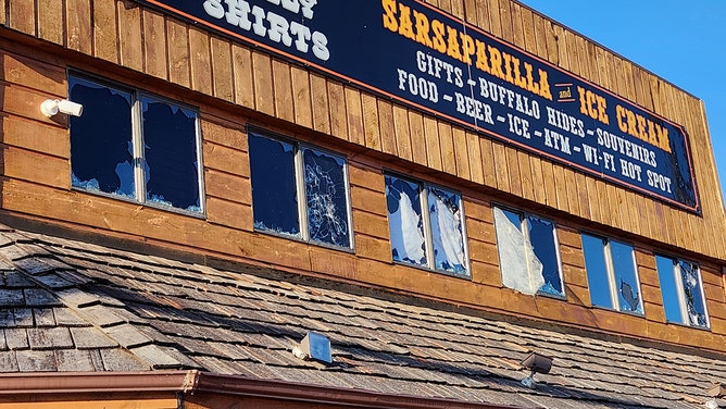
![Here's a look at the damage after the storm outside Devils Tower Trading Post on Monday.]() Image 8 of 9
Image 8 of 9Here's a look at the damage after the storm outside Devils Tower Trading Post on Monday. (Devils Tower Trading Post)
![Late Monday afternoon, a supercell developed across northeast Wyoming and tracked directly over Devils Tower, Wyoming, where it caused extensive damage to trees, buildings, campers and vehicles.]() Image 9 of 9
Image 9 of 9Late Monday afternoon, a supercell developed across northeast Wyoming and tracked directly over Devils Tower, Wyoming, where it caused extensive damage to trees, buildings, campers and vehicles. (Courtesy of Thomas Winesett via NWS)


The widespread storm damage caused the National Park Service (NPS) to close Devils Tower for two days. Park officials said the park reopened Wednesday afternoon.

Several traffic cones and a stop sign lay on the ground after being blown over in a hail storm.
(H. Valls, DETO / NPS Photo)
"We are open and cleaning up well," Tim Davis, the owner of Devils Tower Trading Post, told FOX Weather.
Davis said his business sustained about 20 broken windows and extensive mud accumulation from the hail that fell in front of the store. A 30-foot American flag positioned outside was also torn and devoid of any remaining stars.
"Picnic tables flew out and landed in the parking lot," he added. "Broken trees and all vegetation shredded."
Here's a look at the damage after the storm outside Devils Tower Trading Post on Monday.
(Devils Tower Trading Post)
After the storm, Trading Post Manager Tom Ferguson said people were coming and asking, "Did it snow here?"
The hail left about 18 inches of ice in the Trading Post parking lot.
The NWS said the supercell then tracked east through the Northern Black Hills and onto the plains of western South Dakota and continued to produce large hail, strong winds and heavy rain, before dissipating later in the evening, according to the NWS.

The supercell then tracked eastward into Spearfish, South Dakota.
(Courtesy of Janice Wolfe via NWS)
Devils Tower is a geologic formation that rises out of the prairie near the Black Hills, according to NPS. It is considered sacred by the Northern Plains tribe and other indigenous people. The presence of hundreds of parallel cracks makes it one of the premier crack-climbing areas in North America.
Isolated thunderstorms are possible each day through Friday, the NWS said. A few of the storms may produce hail and strong winds. Critical fire weather conditions are expected Wednesday afternoon and evening across northeastern Wyoming and southwestern South Dakota.