'We're very worried': South Carolinians hunkered down for Hurricane Ian
While the Carolinas will not see the full force of Hurricane Ian the way Florida did, state officials warn residents that they could see high winds, storm surge, rain, flash flooding and even tornadoes into the start of the weekend.
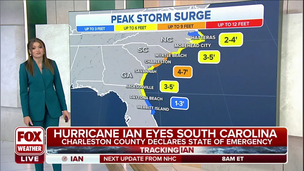
Life-threatening storm surge is expected along the coasts of Georgia and Carolinas
Life-threatening storm surge is expected Friday along the coasts of Georgia and the Carolinas, where a Storm Surge Warning is in effect due to Hurricane Ian.
Visit the FOX Weather Wire for live updates on Ian. Click here for the latest forecast, power outages and more.
CHARLESTON, S.C. – South Carolina, like Florida, is no stranger to storms, hurricanes and other weather-related events.
The Palmetto State sees tropical weather impacts nearly every season, but the last hurricane to make a direct landfall was Hurricane Matthew in 2016.
Hurricane Ian made its final landfall Friday in South Carolina after producing catastrophic damage earlier this week in Florida, where at least 11 people were killed.
While the Carolinas will not see the full force of Hurricane Ian the way Florida did, state officials warn residents that they could see high winds, storm surge, rain, flash flooding and even tornadoes into the start of the weekend.
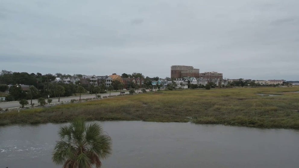
Drone video shows the calm before the storm in Charleston, South Carolina
Drone video shows the calm before the storm in Charleston, South Carolina ahead of Hurricane Ian's arrival.
"Flooding due to storm surge and rain could be a major concern," South Carolina Emergency Management Director Kim Stenson said. "… It will be vital for everyone to be prepared to act if told to do so by your local public safety officials."
South Carolina Gov. Henry McMaster has advised residents in low-lying areas prone to flooding, particularly along the coast, should have a plan to move to higher ground if their homes become unsafe. Local agencies are opening emergency shelters based on need and storm conditions. Shelter locations, when open, will be posted on the South Carolina Emergency Management Division’s website and mobile app.
"We're very worried this morning."
Berkeley County Emergency Management Director Will Rochester said the worst-case scenario they are planning for is one category above.
"So, with it coming to us as a Category 1, we expect a lot of wind, a lot of rain surge in our travel areas," he said. "But we plan for worst-case scenario as a Category 2. So, we know that we've got our responders in place. We've up-staffed our emergency services, fire, police, EMS. We've got our Emergency Operations Center running. So that is our worst-case scenario."
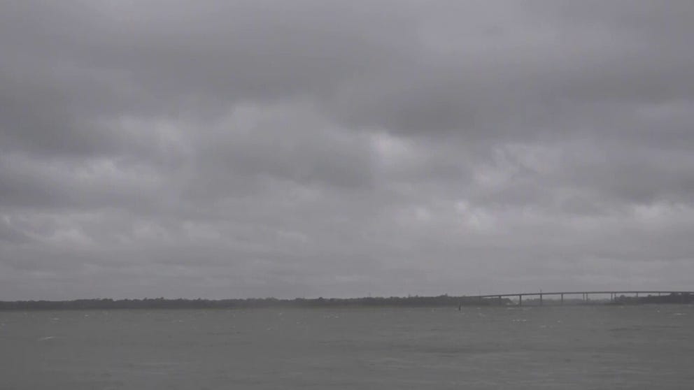
Hurricane Ian moves in on Charleston, SC seawall
Charleston, South Carolina prepares for Hurricane Ian to make landfall.
SOUTH CAROLINA HURRICANE IAN THREAT: YOUR QUESTIONS. ANSWERED.
Rochester said the big concern is that as the county starts to see more water, it will impact the roadways and infrastructure.
"Rescue could be a real possibility as we start to see more water. So, we've got some really low-lying areas in our county that that kind of is a concern, especially for Berkeley County."
On Thursday, President Joe Biden declared an emergency in the state and ordered federal assistance to supplement continuing response efforts from Ian.
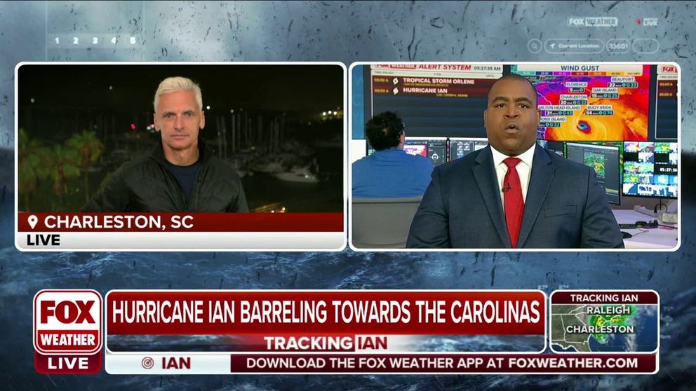
Charleston, SC starting to feel some impacts from Hurricane Ian
Fox News Correspondent Doug Luzader is in Charleston, South Carolina, where they are starting to feel some impacts from Hurricane Ian.
WHERE IS IAN HEADED NEXT? DANGEROUS STORM’S IMPACTS WILL BE WIDESPREAD
"We're very worried this morning," U.S. Rep. Nancy Mace of South Carolina told FOX & Friends First on Friday. "We're hunkered down here right now."
Mace is encouraging everyone not to go in the water Friday.
"Don't go to the beach. Don't get in the ocean. We saw some really horrifying videos in Florida of people doing that. I'm asking people to stay home, stay safe and make sure that they stay off the roads today," she said.
The National Hurricane Center expects winds upwards of 80 mph, a storm surge of between 4 and 7 feet and rains that could be between 6 and 12 inches.
The National Weather Service expects the tide gauge to reach a level of 8.7 feet around the time of Ian’s landfall, which will cause significant issues for Charleston and the Lowcountry of South Carolina.
"And so when you have those kinds of conditions, it's not a matter of if the flooding is going to happen. It's just a matter of when," Mace said.
The FOX Forecast Center anticipates Ian will pick up forward speed, which will bring rain and wind impacts well inland. Computer forecast models suggest inland areas of the Carolinas could get up to 6 inches of rain, which could lead to flash flooding.
Charleston, Columbia, Charlotte, Winston-Salem, Raleigh-Durham and Roanoke are all high-risk zones for flooding from Ian through the weekend.