7 weather changes to expect in August
From the beginning of hurricane season's annual peak to the first snowflakes in the West, there are several weather changes to expect in August
Peak of hurricane season begins in August
The Atlantic hurricane season has been in slumber for nearly a month, but don't expect it to remain quiet for too much longer because the peak of hurricane season is on the way.
August might be the final month of summer, but several notable changes are coming over those 31 days which might remind some Americans that autumn is right around the corner as coastal residents brace for an uptick in hurricanes and tropical storms.
Here are seven weather changes to expect in August:
1. Peak of Atlantic hurricane season begins
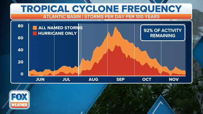
According to the National Hurricane Center, roughly 90% of an average Atlantic hurricane season is still remaining as we head into August.
The period from August through early October tends to produce the most hurricanes and tropical storms in an average year. September is the single most active month of the Atlantic hurricane season, with Sept. 10 marking the official seasonal peak.
HOW TO WATCH FOX WEATHER ON TV
Consequently, this same period is typically when the strongest, most impactful hurricanes roam the Atlantic Basin.
Just in the last five years the U.S. was struck by four hurricanes in August, five in September and four in October. That included last year's Hurricane Ida, which devastated parts of southeastern Louisiana after making landfall as a Category 4 hurricane on Aug. 29.
PEAK OF ATLANTIC HURRICANE SEASON BEGINS IN AUGUST
While the Atlantic hurricane season officially runs from June 1 to Nov. 30, the period from August through early October tends to produce the most hurricanes and tropical storms in an average year.
(FOX Weather)
Compared to June and July, the tropics turn far more active beginning in August because nearly the entire Atlantic Basin becomes available for tropical development.
The so-called Main Development Region between Africa and the Lesser Antilles, which is typically not conducive for storms early in the season because of a frequent influx of Saharan dust and dry air into the region, turns more favorable for development as the dusty, dry air becomes less persistent.
Tropical waves also emerge off western Africa more frequently by August, and if conditions are favorable, they are often seeds for tropical development in the Main Development Region during the peak of hurricane season.
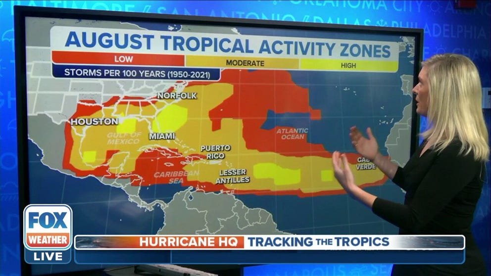
WHERE TROPICAL STORMS, HURRICANES TYPICALLY OCCUR DURING EACH MONTH OF ATLANTIC HURRICANE SEASON
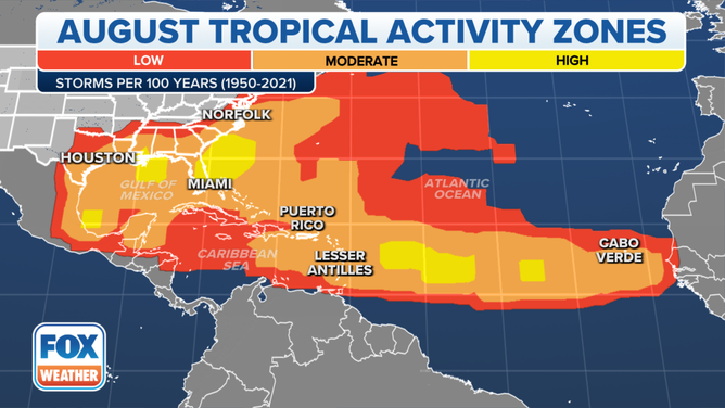
This map shows where tropical cyclone activity tends to occur during August. The data are shown as the combined number of tropical depressions, tropical storms and hurricanes whose centers pass within 125 miles of a point on the map during a 100-year period. The analysis is based on data from the 72-year period from 1950 to 2021 but normalized to 100 years.
(FOX Weather)
If a tropical wave spawns a tropical storm or hurricane in the Main Development Region, it often moves westward across the tropical Atlantic Ocean toward the Lesser Antilles. Some of these storms make the 3,500-mile-long journey from the eastern tropical Atlantic Ocean toward the Caribbean islands or the U.S. coastline, while others curve northeastward toward Bermuda or harmlessly into the open ocean.
Hurricanes that develop in this area to the west of Africa are called Cabo Verde hurricanes, named after the island nation a few hundred miles west of continental Africa.
The Gulf of Mexico is another hot spot for tropical storms and hurricanes to form during the peak of the season because water temperatures in the Gulf reach the highest levels of the year, providing more energy for tropical cyclones to grow and intensify.
2. Decreasing daylight
The long days of summer quickly begin to dwindle as August arrives.
That's because the Northern Hemisphere advances farther beyond the longest day of the year on the summer solstice in June and inches closer to the arrival of fall with the autumnal equinox in September.
Alaska-based climatologist Dr. Brian Brettschneider compiled the data on the map below, which shows how much daylight is lost – or how much darkness is gained – between the first and the last day of August.
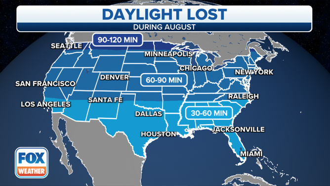
The various blue shadings depict how much daylight is lost between Aug. 1 and Aug. 31. (Data: Brian Brettschneider)
(FOX Weather)
Areas along the U.S.-Canada border from Washington to the Upper Peninsula of Michigan lose between 90 minutes and 2 hours of daylight through the month when considering both the later sunrises and the earlier sunsets. Seattle, for example, has a sunset of 8:43 p.m. on Aug. 1, but that falls all the way back to 7:51 p.m. by Aug. 31.
Most of the nation, however, loses an hour to an hour and a half of sunlight by month's end. In New York City, the 8:11 p.m. sunset on Aug. 1 dips before 7:30 p.m. by the last day of the month.
The change is less noticeable along the southern tier, where 30 minutes to an hour of darkness is gained in August. Dallas' sunset falls 32 minutes from 8:25 p.m. to 7:53 p.m. between the beginning and end of summer's final month.
WHY YOUR SUNSET CHART LOOKS WRONG, EVEN THOUGH IT ISN'T
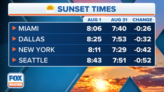
Sunset times in select cities on Aug. 1 vs. Aug. 31.
(FOX Weather)
3. Decreasing temperatures
July is the hottest month of the year for much of the U.S., while August is the second-hottest month.
That means average high temperatures are beginning to fall once the calendar flips from July to August.
In many areas, average highs only drop by a few degrees, so the change isn't all that noticeable. However, there's always an exception to the rule.
WHEN IS THE WARMEST TIME OF YEAR?
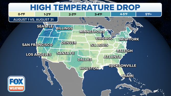
The various colors indicate the drop in average high temperatures between Aug. 1 and Aug. 31. (Data: NOAA/NCEI)
(FOX Weather)
The heat of summer really begins to ease in parts of the interior West and Northwest by August, particularly in the Rockies.
Take Salt Lake City, for example. Its average high drops from a scorching 95 degrees on Aug. 1 to a more tolerable, but still warm 87 degrees by Aug. 31.
On the East Coast, Washington's average high temperature falls from 89 to 86 degrees between the first and the last day of the month, so most people might not even notice the difference.
SUMMER'S HOMESTRETCH: AUGUST WEATHER OUTLOOK
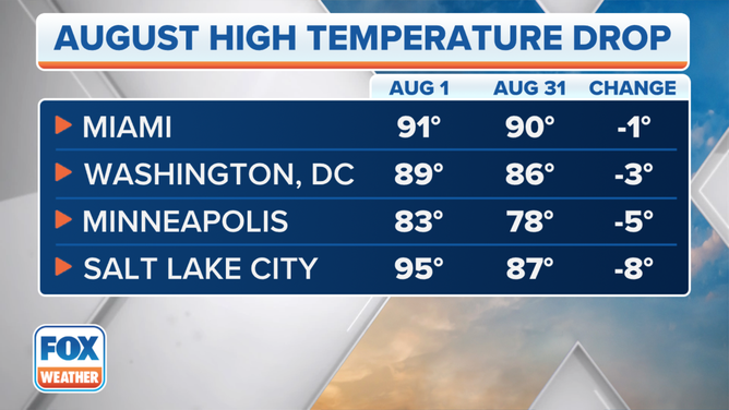
Average high temperatures in select cities on Aug. 1 vs. Aug. 31.
(FOX Weather)
4. August is the wettest month for portions of Southwest, Southeast and Alaska
Precipitation in August varies greatly across the nation, but in some areas, summer ends on a very wet note in an average year.
Brettschneider compiled the map below, which shows where August ranks in terms of the wettest or driest month.
For areas shaded in green, August is the wettest month of the year. That includes portions of the Southwest, Southeast and Alaska.
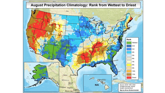
This map shows where August ranks on the scale of the wettest and driest months based on the 30-year period from 1991 to 2020. For areas shaded in green, August is the wettest month of the year. For areas shaded in red, August is the driest month of the year.
(Brian Brettschneider)
The reason for August's wet reputation in the Southwest is the North American monsoon, which kicks off in June and is, therefore, well underway in August.
A monsoon is a term given when winds blow tropical air toward typically desert locations, and the Desert Southwest certainly qualifies.
According to the National Weather Service, a ridge of high pressure in Mexico blocks any moisture from reaching the Desert Southwest in June, allowing for days of hot, dry weather. But by July and, especially, August, the ridge drifts north into the Four Corners region of the U.S., allowing some tropical moisture to be carried north from the Gulf of California and the Pacific Ocean into the Southwest.
Combine the desert heat with the copious amounts of tropical moisture, and you have a setup ripe for strong thunderstorms with torrential rains. What's more, northern Arizona is home to the Mogollon Rim, an area of high elevation that can provide the additional lift needed to trigger thunderstorm development that often will drift into the Phoenix area.
Arizona certainly gets the most attention during the monsoon season, but it also affects New Mexico, southern Utah, Nevada and Southern California. And when the pattern aligns just right, monsoonal moisture can be carried north into the Pacific Northwest.
As summer fades and the continent begins to cool in September, the monsoon season weakens as the conveyor belt of tropical air begins to falter.
WHAT YOU NEED TO KNOW ABOUT SOUTHWEST MONSOON SEASON
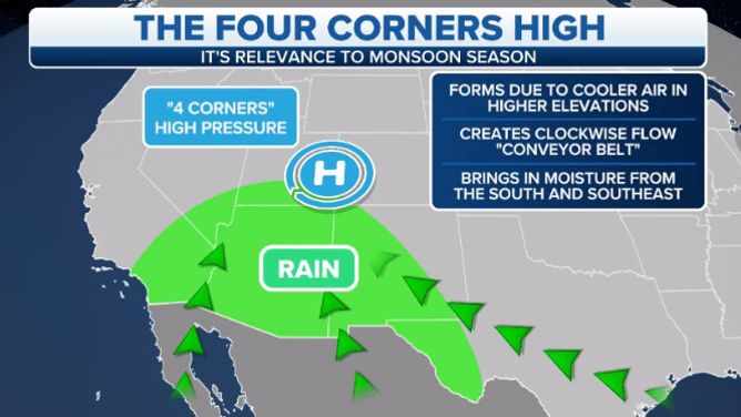
Shown on the map is the typical weather pattern that dominates during much of the North American monsoon season.
(FOX Weather)
August is also the wettest month for parts of the Southeast and Gulf Coast states. This is because of the high frequency of afternoon and evening thunderstorms, as well as the occasional heavy rain event from a tropical storm or hurricane.
WHY IT RAINED WHEN YOUR WEATHER APP SAID THERE WAS ONLY A 20% CHANCE OF PRECIPITATION
5. Driest month for parts of Ohio and Mississippi valleys and interior West
On the other hand, August is the driest month of the year in other portions of the U.S.
Brettschneider also compiled the map below, which shows the driest month of the year based on long-term averages calculated over many years. August is shaded in brown.
Parts of the Ohio and Mississippi valleys and the interior West and Northwest can call August their driest month.
CLICK HERE TO GET THE FOX WEATHER UPDATE PODCAST
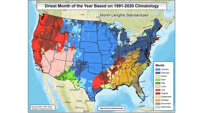
This map shows which month is the driest of the year based on the 30-year period from 1991 to 2020. August is the driest month of the year for some parts of the Ohio and Mississippi valleys and the interior West and Northwest.
(Brian Brettschneider)
6. Tornado threat shifts to northern U.S.
While a tornado can form virtually anywhere during the summer months because of the amount of heat and humidity available for storms, the northern U.S. is particularly vulnerable to twisters in August.
That's because the jet stream is typically parked near the U.S.-Canada border in the summer, so that causes the tornado threat to increase for parts of the northern and central Plains and the Midwest during July and August.
Summer is also the most favorable time of year for twisters in the Northeast and mid-Atlantic states.
HERE'S WHERE TORNADOES ARE MOST LIKELY TO OCCUR IN EACH MONTH

August tornado probability.
(FOX Weather)
7. First snow in the Rockies?
While most of the nation is still sweltering, it's not out of the question that parts of the Rockies can see their first snowflakes before summer comes to a close.
In an average year, the high country of the northern and central Rockies tends to see its first snow in August. That includes the highest mountain peaks in western Montana, western Wyoming and north-central Colorado.
WHEN CAN YOU EXPECT THE FIRST SNOW OF THE SEASON?
Any snow that falls typically doesn't stick to roads or sidewalks because the ground is still very warm and the August sun remains strong. The best opportunity to get a slushy accumulation on the grass or on a vehicle top would be overnight when the sun is not able to melt it as soon as it falls.
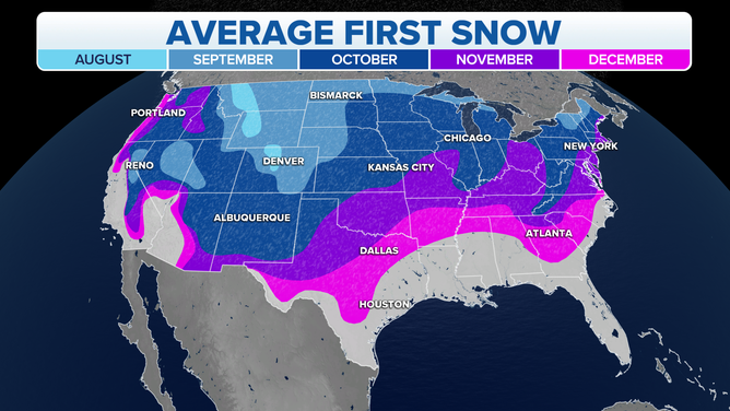
Average date of the first snowfall of the season.
(FOX Weather)