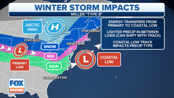
What is a Miller Type B nor'easter?
A Miller “Type B" storm begins with a low-pressure system over the Tennessee Valley into the Appalachians, where a secondary low develops off the southeastern coast and becomes the dominant center.
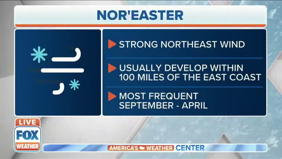
What is a nor'easter?
FOX Weather meteorologist Kendall Smith explains what a nor'easter is.
Nor’easters are powerful storm systems that impact the Eastern Seaboard with a combination of northeasterly winds, heavy precipitation and coastal flooding.
Meteorologists classify nor’easters using the Miller classification system, named after researcher J.E. Miller, from the 1940s.
Originally, only two types of storms - Miller Type A and Miller Type B – were used for identification purposes, but in the early 2000s, forecasters expanded the system to include three additional types, creating five distinct categories: Type A, Type B, Type C, Type D and Type E.
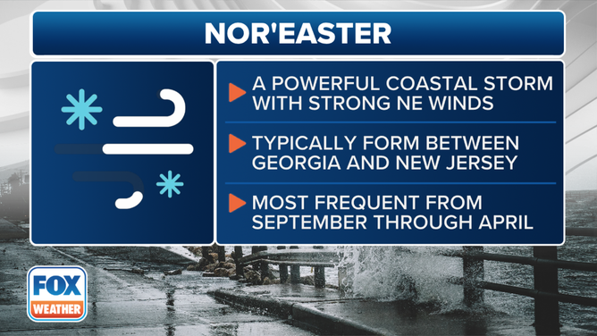
This is the definition and criteria of a nor'easter.
(FOX Weather)
A Miller Type B event is a more west-to-east-originated storm system. These typically occur in the autumn and winter months, when cold air over the continental U.S. clashes with warm, moist air from the Gulf and the Atlantic Ocean.
The resulting event can produce blizzard conditions, hurricane-force wind gusts, severe weather and significant coastal erosion.
Each type of nor’easter has unique characteristics and impact zones that can lead to devastating conditions, with widespread power outages and millions of dollars in damage.
What is a Miller Type B nor’easter and who does it impact?
This type of storm system tends to lead to a more expansive precipitation shield when compared to the zone impacted by a Miller Type A, but there are important caveats.
During a Miller Type B nor’easter, a significant storm system usually races through the Ohio Valley only to fall apart around the Appalachians. The center later redevelops along the East Coast and produces a more significant storm system than compared to the first area of low pressure.
This pattern leads to heavy snowfall in the Ohio Valley as well as higher elevations in the Northeast and New England.
This graphic explains Miller Type-B nor’easters.
(FOX Weather)
Due to the development zone, severe weather across the Southeast is often not a threat, but the risk for significant travel disruptions across the Northeast is usually greater because of less warm air entrained in the nor’easter, which means a greater chance of ice and snow.
It is also important to note that because the center essentially jumps around, Miller Type B nor’easters can be rather tricky to forecast, as a significant jump offshore can limit coastal impacts.
Historical examples of Miller Type B nor’easters
Feb. 25-26, 2004: Southern winter storm
This storm system took an unusual southern path, which caused cities in the Carolinas to see unusually heavy amounts of snow, while most of the Northeast stayed clear of hazardous weather.
Rock Hill, South Carolina, reported 22 inches of snow, while Charlotte, North Carolina, saw more than a foot of snow.

Radar from Feb. 26, 2004.
(Iowa Mesonet / FOX Weather)
South Carolina authorities reported more than 1,400 traffic crashes in the Palmetto State with at least four traffic-related fatalities.
The National Weather Service office that covers much of Georgia also reported widespread snowfall amounts of 1-3 inches in the northern part of the state, associated with an influx of moisture from the west.
Jan. 21-24, 2005: North American Blizzard of 2005
One of the more significant storm systems to impact the Northeast occurred in late January 2005.
The nor’easter produced heavy snowfall, hurricane-force winds and coastal flooding, leading to widespread travel disruptions.
The event was enhanced by arctic air that was already in place, which caused much of the precipitation to fall in the frozen variety.
This storm system took on the more classic form of a Miller Type B nor’easter and produced feet of snow and blizzard conditions for Connecticut, Rhode Island and Massachusetts.
Before the main low-pressure center took over, the first low-pressure system caused significant snowfall across the Great Lakes.
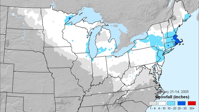
North American Blizzard of 2005 snowfall map.
(NOAA)
Feb. 4-7, 2010: Snowmageddon
Despite being an El Niño year, conditions typically associated with La Niña led to the development of a significant nor’easter.
This system caused blizzard conditions in the Northeast, with widespread reports of 30 inches of snow in parts of Pennsylvania, Maryland, Virginia and West Virginia.
More than 40 fatalities were reported, and hundreds of thousands of homes lost power due to the Miller Type B storm, which came to be known as "Snowmageddon."
The storm system drew a significant amount of moisture from the Gulf, which helped to intensify the impact in the northern mid-Atlantic and southern Northeast states.
The greatest snowfall total was recorded in Maryland, with 38.3 inches measured in Elkridge.
While the southern end of the storm system produced flooding, there were no widespread reports of severe weather.
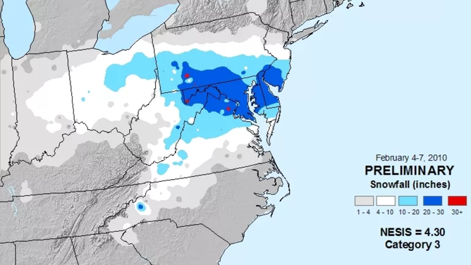
Snowfall map accumulation from February 2010.
(NOAA)