Type of nor’easter: Miller Type E storm system explainer
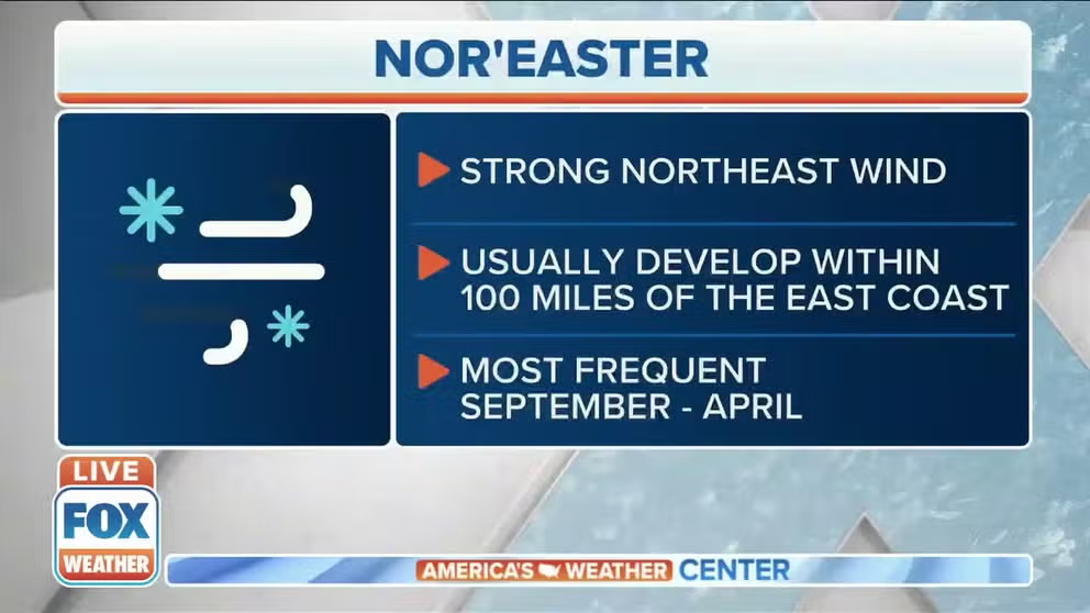
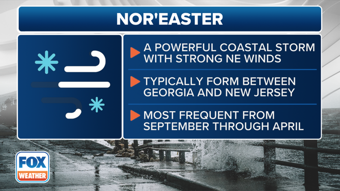
Meteorologists identify nor’easters based on their paths and impacts by using the Miller classification system, named after researcher J.E. Miller, from the 1940s. These storm systems, which typically occur in the fall and winter months, form when cold air over the continental United States clashes with warm, moist air from the Gulf and the Atlantic Ocean. Heavy snow, severe weather, damaging wind gusts, coastal flooding and erosion are all possible during a nor’easter event.
What is a nor'easter?
FOX Weather meteorologist Kendall Smith explains what a nor'easter is.
If there’s one type of nor’easter you should stock up with essentials like bread and milk, it’s a "Miller Type E" storm system.
This unique system can be significant, bringing widespread impacts along its track, from the Gulf Coast through Texas and Louisiana, across Florida, and up the Eastern Seaboard.
Depending on the low's exact path, heavy snow can fall from Canada all the way to the Deep South, affecting cities such as Atlanta, Charlotte, Baltimore, New York City, Philadelphia and much of New England.
Meteorologists identify nor’easters based on their paths and impacts by using the Miller classification system, named after researcher J.E. Miller, from the 1940s.
These storm systems, which typically occur in the fall and winter months, form when cold air over the continental United States clashes with warm, moist air from the Gulf and the Atlantic Ocean. Heavy snow, severe weather, damaging wind gusts, coastal flooding and erosion are all possible during a nor’easter event.
For decades, nor’easters were typically classified as Miller "Type A" or Miller "Type B," but starting in the 2000s, climatologists developed additional categorizations for Miller "Type C," Miller "Type D" and Miller "Type E" storm systems.
Similar to a Miller Type D storm, the subtropical jet is highly energized during a Miller Type E event, which often occurs during an El Niño winter.
Heavy snow, severe weather, damaging wind gusts, coastal flooding and erosion are all possible during a Miller Type E nor’easter.
This is the definition and criteria of a nor'easter.
(FOX Weather)
What is a Miller Type E nor’easter, and who does it impact?
During this setup, two areas of low pressure often exist east of the Rockies: a fast-moving clipper system over the Great Lakes and a much stronger low-pressure system that rapidly deepens along the coast.
The two systems eventually combine forces over the Northeast and New England, but the nor’easter wouldn’t exist without the powerful coastal low.
Due to significant moisture, heavy snow often falls from the Deep South through Canada, but the exact snowbelt depends on the trajectory of the main area of low pressure.
A track over the Eastern Seaboard allows warm air to stream northward, creating the potential for mixed precipitation along the coast.
A track offshore puts much of the I-95 corridor directly in the path of the heaviest snowfall.

Miller Type E storm system pattern
(Sussex County, New Jersey/Siebers n.d. / FOX Weather)
Fortunately, this type of setup is rather infrequent, but when it does occur, it can lead to significant impacts.
In addition to the threats of ice and snow, a Miller Type E nor’easter can also trigger severe weather in Florida, including damaging winds and tornadoes.
Historical examples of Miller Type E nor’easters
January 24-26, 2000: Carolina Crusher
In late January, a Miller Type E nor’easter nicknamed the "Carolina Crusher" produced widespread snow from eastern Georgia through the mid-Atlantic and Northeast.
Some areas in Virginia received over 20 inches of snow, and heavy accumulations were reported in Washington, D.C., Philadelphia, Baltimore, Richmond and Raleigh.
Raleigh even set an all-time record with 20.3 inches of snow reported at Raleigh-Durham International Airport.
The heavy snow caused widespread power outages, with schools and businesses closed for days.
Many were caught off guard, as computer models struggled to accurately predict the storm’s widespread impacts.
Additionally, according to a NOAA summary, it was a rather mild winter, with below-average snowfall totals, so some residents may not have been expecting such a lashing from Old Man Winter.
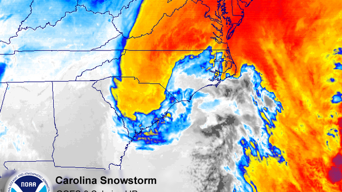
January 24-26, 2000: Carolina Crusher
(NOAA)
February 16-17, 1996: Blizzard of 1996
The Blizzard of 1996 remains a benchmark against which all winter storms are measured.
Snowfall blanketed nearly two dozen states, with the heaviest precipitation concentrated around the nation's capital and in parts of Massachusetts, New Hampshire and Vermont, where more than three feet of snow were reported.

A look back at the "Blizzard of '96"
26 years ago the famed "Blizzard of '96" dumped feet of snow across the East
Governors from the mid-Atlantic to New England declared states of emergency due to widespread flooding and heavy snow, which made travel nearly impossible.
No state along the Eastern Seaboard was unaffected, and the National Weather Service reported snow flurries as far south as South Florida.
In some boroughs around New York City, up to 20 inches of snow fell, accompanied by winds gusting to around 50 mph.
According to NOAA estimates, the storm resulted in at least 150 fatalities, and, at the time, damage was estimated at around $3 billion.
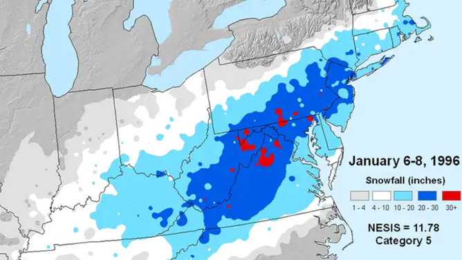
February 16-17, 1996: Blizzard of 1996
(NOAA)