What is a squall line and why is this type of severe weather so dangerous?
Squall lines can stretch for hundreds of miles and persist for many hours, producing destructive winds, hail and even tornadoes along their path
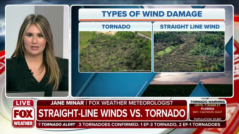
Straight-line wind damage vs. tornado: What's the difference?
FOX Weather meteorologist Jane Minar explains the difference between the types of wind damage: straight-line winds and a tornado.
When severe weather is threatening your area, FOX Weather meteorologists might mention the term "squall line" to describe the storms barreling in your direction.
As the term suggests, squall lines are thunderstorms organized in a line, typically arranged from north to south. According to the National Weather Service, these dangerous lines of storms can stretch for hundreds of miles and persist for many hours, producing destructive winds, hail and even tornadoes along their path.
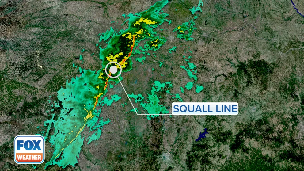
An example of a squall line on Doppler radar is shown in the image below.

This Doppler radar image shows an example of a squall line.
(FOX Weather)
While squall lines will almost always pack a damaging wind threat, the intensity of the winds depends on atmospheric conditions such as instability and how strong the winds are aloft. The most intense squall lines often produce widespread 60- to 80-mph gusts.
‘DESTRUCTIVE’ THUNDERSTORM ALERTS: WHAT THEY ARE AND WHY THE NWS ISSUES THEM
According to data from NOAA's Storm Prediction Center, the U.S. averaged 13,821 wind damage reports over the 10-year period from 2012 to 2021. Damaging winds are defined by the NWS as 58 mph or higher.
Winds of this magnitude can not only knock down trees and power lines, but the highest gusts can cause damage to homes and other buildings. Any large hail produced by the storm can also be blown around by these strong winds, driving the hailstones fiercely toward homes and vehicles and causing even more destruction.
The evolution of a squall line
This animation depicts the evolution of a squall line and the widespread damaging winds associated with this type of severe weather event.
A derecho is an example of a squall line that must reach specific criteria, including a path of wind damage that spans at least 250 miles. It's not uncommon for the most powerful derechos to produce wind gusts over 100 mph. However, not all squall lines are derechos.
One of the most significant derecho events in U.S. history occurred across a 770-mile swath of the Midwest on Aug. 10, 2020. During this extreme event, winds gusted upward of 140 mph, causing an estimated $11.5 billion in damage.
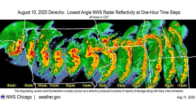
Hourly radar images of the Aug. 10, 2020, derecho's progression across the Midwest.
(NWS Chicago)
If the NWS issues a Severe Thunderstorm Warning for damaging winds associated with a squall line or derecho, it is advised that you move indoors and stay away from windows and doors just as you would during a Tornado Warning.
Squall lines can also produce tornadoes
Speaking of tornadoes, many squall lines will also spawn twisters.
Tornadoes can spin up quickly along the squall line's leading edge of severe thunderstorms that are most likely already packing destructive winds.
Any tornadoes associated with a squall line tend to be brief, but they might be difficult to see due to the large area of heavy rain surrounding them.
While strong tornadoes on the order of EF-2 or higher can occasionally develop with a squall line, the vast majority tend to be EF-0 or EF-1 twisters.
HOW ARE TORNADOES RATED? THE ENHANCED FUJITA SCALE EXPLAINED
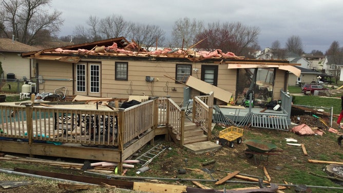
A National Weather Service survey team confirmed an EF-1 tornado in eastern St Joseph, Missouri, on Tuesday, March 29, 2022.
(NWS Kansas City)
Don't forget about the dangerous lightning and torrential rain
Squall lines can produce thousands of cloud-to-ground lightning strikes per hour.
If you can hear thunder or see lightning, the NWS advises you to seek shelter immediately in a sturdy building or, if a building is not available, a hard-topped vehicle with the windows rolled up.
When indoors, you should refrain from using corded appliances or other equipment or facilities that put you in contact with electrical systems or plumbing.
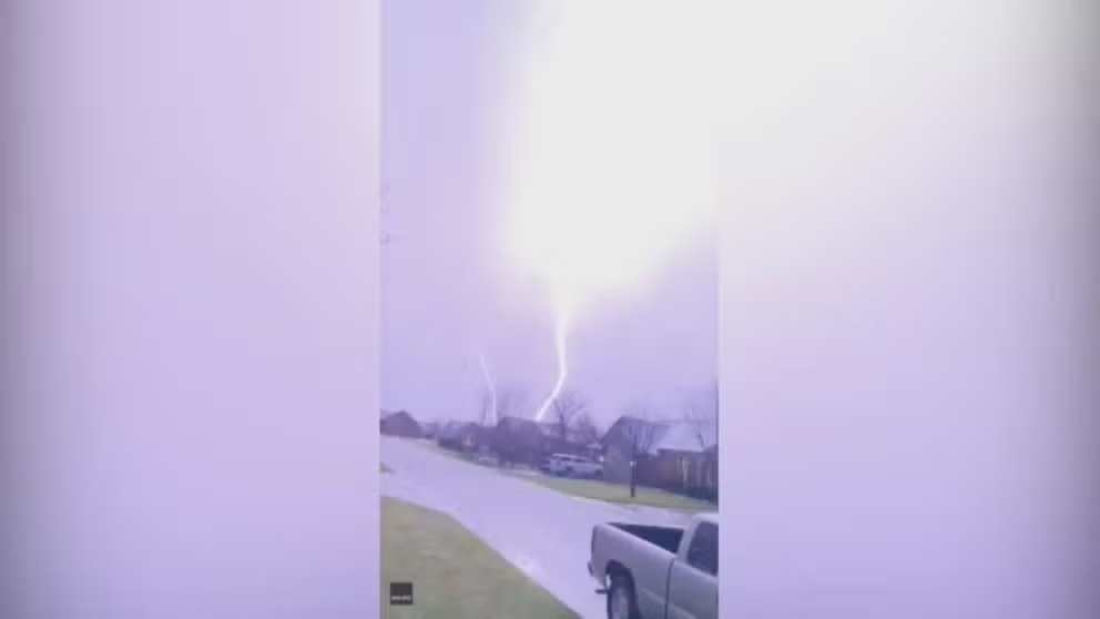
Watch: Kansas 'insane' upward lightning electrifies the night sky
Upward lightning electrified the Wichita, Kansas, night sky on Tuesday.
It's not safe to go back outside until the storms have moved away and you can no longer hear thunder. According to the NWS, lightning often strikes more than 3 miles away from the center of the storm, so even if the thunder sounds far away, there's still a chance you could be struck by lightning.
WHAT HAPPENS WHEN SOMEONE IS STRUCK BY LIGHTNING
In addition, a squall line might produce torrential rainfall rates exceeding an inch per hour. This can significantly reduce visibility, posing a major hazard to drivers caught in the storm.
It is best to delay travel until the squall line has passed, assuming it's safe to do so in the wake of any storm damage.