A look at the climate for the most famous streets around America
The country’s busiest travel periods are around Christmas and New Year’s, but Memorial Day, July Fourth and Labor Day all see significant upticks in travelers, according to the Transportation Security Administration.
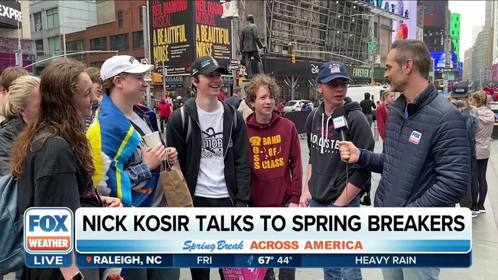
New York City tourists talk top spring break destinations
Whether it is fun in the sun or maybe taking turns down the slopes for spring skiing, everyone is itching for a little fun outside. No one knows this better than FOX Weather meteorologist Nick Kosir. He caught up with some people visiting New York City over spring break and asked them about
While every community has a street that is the main attraction of that locale, certain roadways have gained a life of their own and have become major tourist attractions.
Most are in big metroplexes, where the population can support the entertainment, dining and other venues that are major draws at these destinations.
Most famous streets around the country have a continental climate, with warm summers and cold winters.
Due to the variations in weather conditions, the tourist season swells during the spring and summer and tappers off at many during the fall and winter.
So, before you pack your bags, here’s a look at the climate of some of America’s most renowned streets.
5 WEATHER STORIES THAT ARE AS AMERICAN AS APPLE PIE
Michigan Ave - Chicago, Illinois
- Zip Code: 60611
- Warmest average high temperature: 85°F (July)
- Coldest average high temperature: 33 °F (January)
- Yearly precipitation: 40.88"
- Current weather for Chicago: See latest conditions & forecast
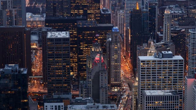
CHICAGO, USA - FEBRUARY 24: A skyline view of Chicago from the Chicago observation deck, on the 94th floor of the John Hancock Building, located at the Michigan Avenue, in Chicago, United States on February 24, 2018.
(Photo by Bilgin S. Sasmaz/Anadolu Agency/Getty Images / Getty Images)
A stretch of Michigan Avenue that is home to upscale retail and other attractions is known as The Magnificent Mile. According to The Magnificent Mile Association, the 13-block stretch of North Michigan Avenue is home to more than 460 stores, 275 restaurants and 60 hotels.
The region’s proximity to Lake Michigan tends to make it cooler during the summer and warmer during the winter.
January is the city’s coldest and snowiest month, with some 38.8" of frozen precipitation that falls every year.
The 307-mile-long lake can help increase wind speeds in the Chicagoland region, but the nickname of the "Windy City" is not at all weather-related.
According to NOAA’s National Climatic Data Center, the yearly average wind speed is around 10.3 mph, which ranks lower than many cities, including Boston, Minneapolis and Kansas City, Missouri.
It is widely cited that Cincinnati labeled Chicago the "Windy City" as part of a jab during the 1800s, as the communities were rivals in many aspects of society after the Industrial Revolution.
Lombard Street - San Francisco, California
- Zip code: 94133
- Warmest average high temperature: 70 °F (September)
- Coldest average high temperature: 58 °F (January)
- Yearly precipitation: 22.89"
- Current weather for San Francisco: See latest conditions & forecast
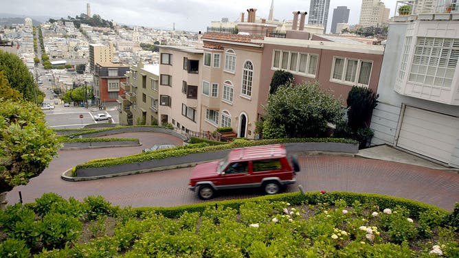
SAN FRANCISCO - APRIL 29: A single car drives down a typically crowded Lombard Street, San Francisco's crooked street, April 29, 2003 in San Francisco. With the war in Iraq, the SARS outbreak and a weak economy, tourism in major American port cities, like New York, San Francisco and Miami is on the decline.
(Photo by Justin Sullivan/Getty Images / Getty Images)
The City of San Francisco says the most crooked street in the world draws more than 2 million visitors annually. While Lombard Street extends for more than 2 miles, it is a one-block section in the upscale Russian Hill neighborhood that everyone yearns to visit.
So, why does the street resemble a snake? According to the group Visit California, engineers designed the street to be safe for automobiles and walkers during the 1920s when the conveniences of modern brakes weren’t around. Without the zig-zagging nature, the incline of 27 degrees would be daunting for even the best driver.
The San Francisco Bay Area is home to several microclimates due to the terrain and nearby maritime influence.
Due to a rather steady onshore flow, summers can be cool with plenty of fog, while winters stay rather warm and rainy.
Ocean Drive – Miami Beach, Florida
- Zip code: 33139
- Warmest average high temperature: 88 °F (August)
- Coldest average high temperature: 74 °F (January)
- Yearly precipitation: 57.18"
- Current weather for Miami: See latest conditions & forecast
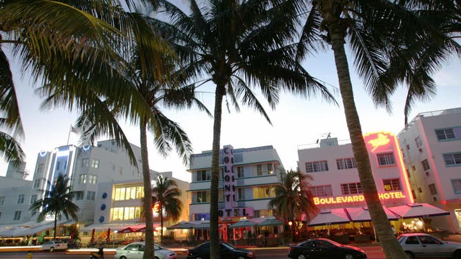
MIAMI BEACH, UNITED STATES: Renovated hotel buildings overlooking Ocean Drive are adorned by neon lights in the early evening 26 September 2006. The city of Miami Beach has a concentration of over 800 Art Deco buildings all within one square mile. The white-and pastel-colored stucco buildings originally built in the 1920's have in the past two decades been restored to their former splendor. Some of the characteristics of the Art Deco movement in Miami include over-all symmetry, ziggurat (stepped) rooflines, glass block, decorative sculptural panels, eyebrows, round porthole windows, terrazzo floors, curved edges and corners, elements in groups of three and neon lighting used in both exteriors as well as interior spaces. The chamber of commerce for the city reports that some 7,281,200 visitors came to South Beach in 2004.
(ROBERTO SCHMIDT/AFP via Getty Images / Getty Images)
The main thoroughfare in Miami’s South Beach is dotted with hotels, restaurants and bars. This area is commonly referred to as the Art Deco district and has served as the backdrop to many movie and television scenes.
Due to its proximity to the Atlantic, Ocean Drive stays cooler than inland communities of South Florida, though it does not come without its perils.
At least once a year, South Florida is threatened by tropical cyclone activity between June and November.
Outside of the threat of hurricanes, thunderstorms are numerous and occur on more than 80 days of every year.
The Miami–Fort Lauderdale metro was declared the most impacted region by lightning in a 2023 study by Vaisala, a global technology company.
More than 120,000 cloud-to-ground lightning strokes were tallied, making the region the most lightning-prone metropolitan area in the country.
It doesn’t have to be rainy to see high water levels along the coast. A phenomenon known as sunny-day flooding has increased in frequency in low-lying coastal areas.
The rise in water levels has been attributed to climate change and high tide cycles.
Bourbon Street - New Orleans, Louisiana
- Zip code: 70112, 70130
- Warmest average high temperature: 91°F (July)
- Coldest average high temperature: 63 °F (January)
- Yearly precipitation: 63.35"
- Current weather for New Orleans: See latest conditions & forecast
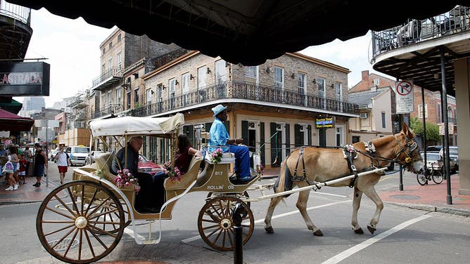
NEW ORLEANS, LA - OCTOBER 5: A horse draws a carriage along Bourbon Street October 5, 2002 in the French Quarter of New Orleans, Louisiana. With Its exquisite Spanish architecture, elegant shops, lacy ironwork, restaurants and jazz clubs, the French Quarter is a popular destination. The 120 block Quarter, nestled on a bend of the Mississippi River, has many buildings dating back to 1700's.
(Photo by Joe Raedle/Getty Images / Getty Images)
A tourist attraction that constitutes about 13 blocks of the French Quarter is the world-famous Bourbon Street. The street is often the center attraction during big events such as Mardi Gras, Jazz Fest and pop-up festivals.
The area was named after French explorers founded the city in the early 1700s, and ever since then, residents have battled a wide variation of weather impacts.
Due to the proximity to the Mississippi River, Lake Pontchartrain, marshes and the Gulf of Mexico, high humidity levels are quite common. Levels typically peak in August and are lowest in March.
Temperature extremes are common since summers are warm and winters are rather chilly.
The official weather observation site at the Louis Armstrong International Airport reached its coldest value ever on February 13, 1899, at 6 °F and recently reached an all-time record high of 105 °F on August 27, 2023.
Being located on the Gulf of Mexico also makes the city and the French Quarter susceptible to hurricanes.
According to a NOAA historical database, the city is impacted by a hurricane about once every decade, but other locations in Louisiana experience more frequent events.
Hurricane Katrina in 2005 caused extensive damage along the Gulf Coast, but the French Quarter was largely spared from the flooding because of its high terrain and limited storm surge.
Due to extreme weather events during the summer and the fall, most tourist activities are held during the first half of the year.
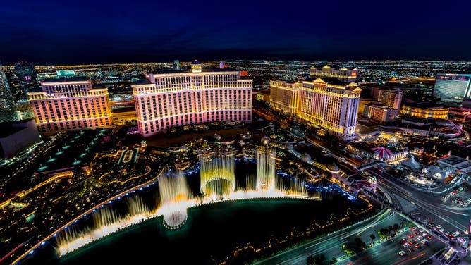
Las Vegas Blvd. – Las Vegas, Nevada
- Zip code: 89109, 89119
- Warmest average high temperature: 105 °F (July)
- Coldest average high temperature: 57 °F (December)
- Yearly precipitation: 4.18"
- Current weather for Las Vegas: See latest conditions & forecast
Panoramic View of Las Vegas Nevada at night with neon from Paris Eifel Tower view spot.
(Photo by: Visions of America/Education Images/Universal Images Group via Getty Images / Getty Images)
A 4-mile stretch of Las Vegas Boulevard is known as the world-renowned Strip, which is home to casinos, hotels, restaurants and entertainment. According to the Las Vegas Convention and Visitors Authority, more than 40 million people visit the Strip yearly, with around 6 million just for conventions.
Fortunately, most venues are indoors, which keeps visitors from being exposed to the region’s extreme weather.
When ridges of high pressure are in control, temperatures can soar to well over 100 °F.
The all-time record temperature is 117 °F, which was set back on July 10, 2021.
When the ridges of high pressure lose control during the summer, the monsoon pattern can kick in, producing flooding rains.
On average, Sin City receives less than 5" of rainfall but also occasionally sees snow.
According to National Weather Service data, Southern Nevada sees 0.3" of snow annually, but many years end up accumulating less than a trace.
The most snowfall ever reported happened during the winter of 1948-49, when 16.7" fell.
WHAT ARE EL NINO AND LA NINA CLIMATE PATTERNS?
Broadway Street - New York, New York
- Zip code: 60611
- Warmest average high temperature: 85 °F (July)
- Coldest average high temperature: 40 °F (January)
- Yearly precipitation: 49.52"
- Current weather for New York: See latest conditions & forecast
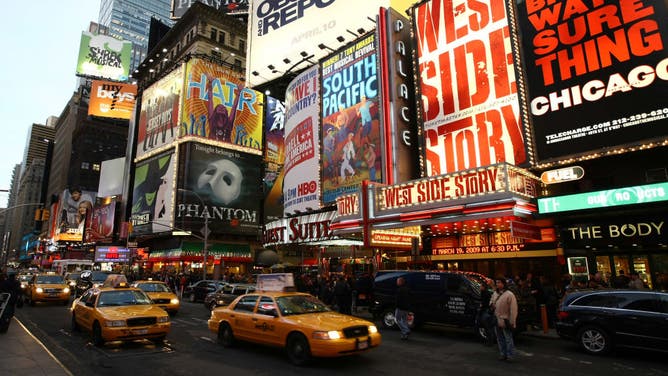
NEW YORK - MARCH 19: A exterior view of the Palace Theatre at the opening night of "West Side Story" on Broadway at the Palace Theatre on March 19, 2009 in New York City.
(Photo by Neilson Barnard/Getty Images / Getty Images)
The nickname of "The Big Apple" has nothing to do with the popular fruit but is said to have originated from horse racing in the 1920s.
In the city of more than 8 million people, Broadway Street runs for more than 13 miles from Manhattan through Times Square.
New York City annually hosts more than 60 million visitors a year from all over the world.
Due to its proximity to the water, portions of the city are considered to lie in a humid subtropical zone, but it can also can be characterized as a humid continental climate.
Its location in the mid-latitudes assures it is susceptible to weather extremes.
Central Park’s coldest day happened on February 9, 1934, when the mercury reached -15 °F, and its warmest day ever was 106 °F on July 9, 1936.
Snowfall is highly variable and can occur on any date between October and late April.
The greatest snowfall event happened during the historic blizzard of 2006, when many cities along the I-95 corridor were snowed in.
Central Park reported nearly 27" of snow – its all-time record event.
Pennsylvania Avenue – Washington, D.C.
- Zip code: 20006, 20005
- Warmest average high temperature: 90 °F (July)
- Coldest average high temperature: 45 °F (January)
- Yearly precipitation: 41.82"
- Current weather for Washington: See latest conditions & forecast

The residence of the President of the United States, known as the White House, Washington, DC, late 20th Century.
(Photo by Lambert/Getty Images / Getty Images)
No other street screams Americana more than Pennsylvania Avenue, which connects the United States Capitol to the White House. All states and the territory of Puerto Rico have a roadway named after them in the District of Columbia, but it is believed that Pennsylvania got the prime naming rights since Philadelphia was the first capital city after the Constitution was ratified.
Summers are typically mild and humid, while winters produce varying degrees of severity.
The average humidity level of between 60-70%, in combination with temperatures around 90 degrees, often triggers heat emergencies.
The city averages just under 14" of snow a year, with the first trace occurring around Thanksgiving and the last few inches happening in March.
Due to its location along the Potomac River and the Tidal Basin, locations such as the National Mall and Georgetown are vulnerable to flooding caused by heavy rainfall and high tides.
The National Park Service has embarked on a nearly $200 million project to enhance bulkheads and seawalls around historic sites, but more than 100 cherry trees will have to be removed.
SEE THE OBJECTS HUMANS LEFT BEHIND ON THE MOON
Beale Street - Memphis, Tennessee
- Zip code: 38103
- Warmest average high temperature: 92 °F (July)
- Coldest average high temperature: 51 °F (January)
- Yearly precipitation: 54.94"
- Current weather for Memphis: See latest conditions & forecast
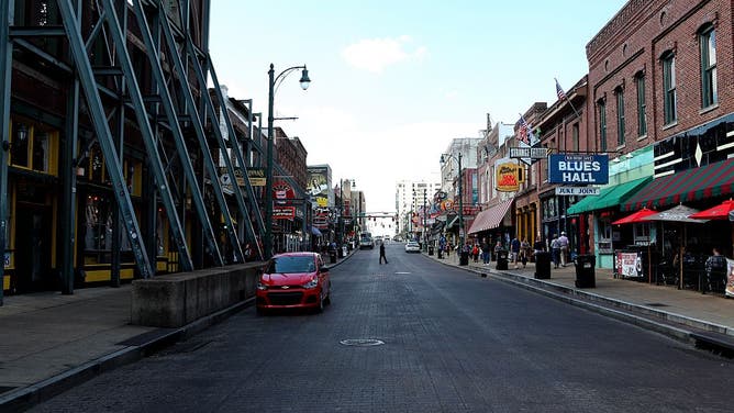
MEMPHIS - OCTOBER 03: Beale Street in Memphis, Tennessee on October 3, 2016.
(Photo By Raymond Boyd/Getty Images / Getty Images)
Beale Street is a National Historic Landmark in the heart of Memphis, Tennessee, that serves as the Home of the Blues and is often linked to the start of Elvis Presley’s career. Presley’s Graceland estate is less than a 20-minute drive from Beale Street.
Due to the region’s location next to the Mississippi River, extreme flooding can threaten the area.
Memphis’ mid-South location allows for a great deal of variability in weather patterns.
Severe weather season typically runs from February into May, with a secondary peak in the late fall.
The city’s highest reported temperature occurred on July 13, 1980, when the mercury reached 108 °F.
Heat waves are fairly common during the summer when the heat index can soar to well over 100 degrees. The index is a measure of how hot it feels to your body when the humidity factor is combined with the air temperature.
Less common extreme events include earthquakes and snowstorms.
Hollywood Boulevard – Los Angeles, California
- Zip code: 90046, 90028, 90027
- Warmest average high temperature: 79 °F (August)
- Coldest average high temperature: 67 °F (February)
- Yearly precipitation: 17.73"
- Current weather for Los Angeles: See latest conditions & forecast

A film poster for Oppenheimer at TCL Chinese Theatre on the Hollywood Walk of Fame in Los Angeles, California, US on Friday, July 21, 2023. As buzz builds into the premieres of Barbie and Oppenheimer, some on Wall Street are doubting whether the films will be enough to power further gains in movie-theater stocks as a strike by Hollywood writers and actors clouds the outlook for the industry. Photographer: Eric Thayer/Bloomberg via Getty Images
(Eric Thayer/Bloomberg via Getty Images / Getty Images)
Museums, landmarks and other destinations sit along a nearly 5-mile stretch of Hollywood Boulevard. Around the boulevard are more than 2,700 brass stars who honor professionals in entertainment along the Hollywood Walk of Fame.
According to the Walk of Fame Committee, a person can receive a star for: professional achievements, longevity in the entertainment industry, contributions to the community and a guarantee they’ll be at the dedication.
The weather across Southern California doesn’t have a great deal of variability, with a yearly maximum average temperature of 75 degrees.
Exceptions happen and according to the region’s official observation site, Los Angeles has been as warm as 113 degrees and as cold as 28 degrees.
Its location along the Pacific’s Ring of Fire means earthquakes are relatively common, with around 100 occurring daily in the Golden State.
The costliest earthquake in the country’s history impacted the region on Jan. 17, 1994.
According to the State of California, the magnitude 6.7 quake, known as the Northridge earthquake, killed at least 72 people and led to $60 billion in losses.
Geologists say earthquakes in this part of California are not triggered directly by the San Andreas Fault but by what are known as thrust faults.
WHAT HAPPENS UNDERWATER DURING A HURRICANE?
International Drive – Orlando, Florida
- Zip code: 32821, 32819, 34746
- Warmest average high temperature: 92 °F (July)
- Coldest average high temperature: 72 °F (January)
- Yearly precipitation: 51.45"
- Current weather for Orlando: See latest conditions & forecast
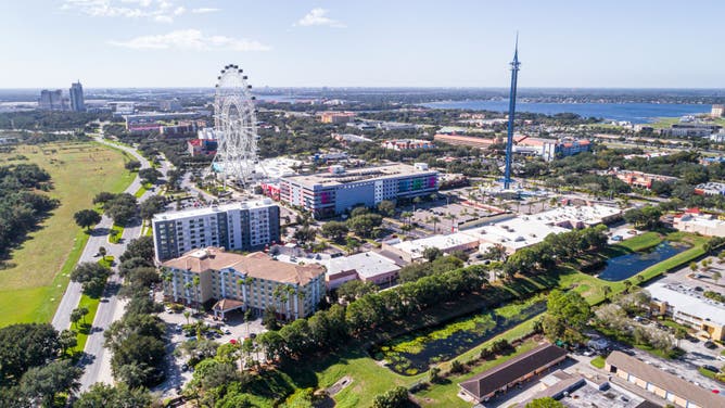
Florida, aerial view of The Wheel at ICON Park, Orlando Star flyer swing, amusement park ride.
(Photo by: Jeffrey Greenberg/Universal Images Group via Getty Images / Getty Images)
I-Drive is one of the main thoroughfares in Orlando’s tourist district and sits just outside of theme parks such as the Magic Kingdom and Universal. The region is one of the top destinations for attractions, dining and shopping outside of the major theme parks. It’s home to Madame Tussauds wax museum, SeaWorld, a giant Ferris wheel, the world’s largest McDonald’s and much more.
An average summer day usually tops out at around 92 degrees, while an afternoon during the heart of the winter can reach the lower 70s.
The combination of warm air temperatures, moisture and sea breezes are the main ingredients that align for showers and thunderstorms to pop up during the afternoons.
In Orlando, the rainy season begins around May 27, when it is not uncommon for storms to produce damaging winds, hail, lightning or even waterspouts and brief tornadoes.
Being centered in the Peninsula means the threat for tropical cyclones exists from June through November.
Orlando is about an hour’s drive from the Atlantic coast and a two-hour drive from the Gulf of Mexico.
Since the 1970s, there have been less than a dozen occasions when major theme parks have temporarily halted operations due to an impending hurricane.