What is an atmospheric river?
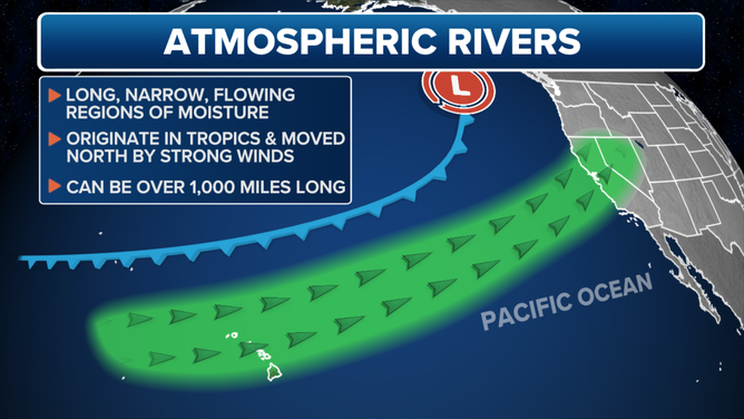
What causes an atmospheric river is a narrow corridor of concentrated water vapor -- usually from tropical origins -- that is being carried by the jet stream. These are Earth's largest rivers -- but in the sky.

What is an 'atmospheric river?'
FOX Weather Meteorologist Craig Herrera shows us how these massive rain storms that can stretch 250-350 miles wide and over 1,000 miles long can both be a benefit -- and a bane to the West Coast.
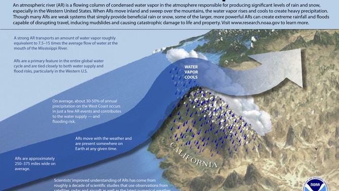
The science behind an atmospheric river storm can be compared to the mighty Mississippi River that bisects the heart of America and all the water it carries.
Now imagine 15 times that amount of water flowing in the skies above as a storm brings hours of torrential rainfall.
These kinds of rainstorms are a reality along the West Coast multiple times in autumn and winter when the region is struck by what's known as an atmospheric river.
The term describes a narrow corridor of concentrated water vapor – usually from tropical origins – that is being carried by the jet stream, according to the Center for Western Weather and Water Extremes (CW3E). Think of it as a river of water vapor in the sky.
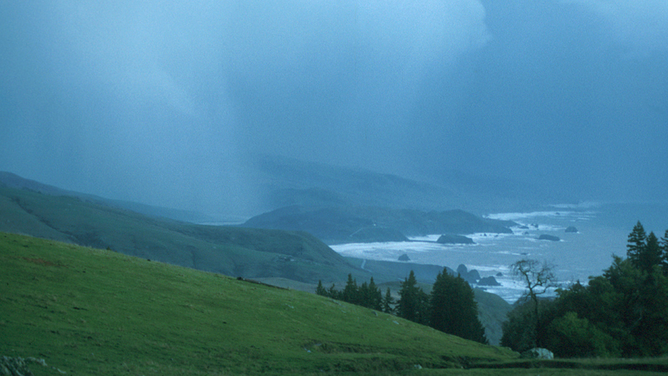
A storm darkens the sky at the mouth of the Russian River, north of Bodega Bay, Calif. The storm was driven largely by an "atmospheric river" over California. (NOAA)
(NOAA)
Wherever this "river" comes ashore, it will be drenched with a period of moderate-to-heavy rainfall – sometimes for 48 hours or more.
Heavier rains fall when atmospheric rivers crash into mountain ranges. As air is forced upward on the windward side of mountains, the moisture will be wrung out of the atmosphere like a sponge, dropping several inches of rain into mountain river basins. Intense atmospheric river events frequently lead to extensive river flooding.
(FOX Weather)
While atmospheric rivers typically bring their most significant rainfall to the coastal areas, their impacts can travel hundreds of miles inland, bringing heavy rain to interior locations.
(NOAA)
When do chances of an atmospheric river increase?
A vast majority of atmospheric rivers happen in the fall and winter. The northern Pacific Coast receives the bulk of activity in the fall, and the California coast receives more in the winter. While rare, atmospheric rivers are possible in the spring and summer months.
Are atmospheric rivers just a West Coast thing?
In the U.S., nearly all atmospheric rivers occur along the Pacific Coast, but they can happen anywhere in the country.
In the spring of 2010, a robust atmospheric river came off the Gulf of Mexico and struck the southeastern U.S., bringing record flooding to the Tennessee Valley, according to the CW3E.
Atmospheric rivers represent a forecasting challenge
Forecasters can use satellite imagery and ground observations to plot atmospheric rivers by measuring the amount of water vapor entrenched in the storm. However, forecasting where they will go remains quite a challenge.
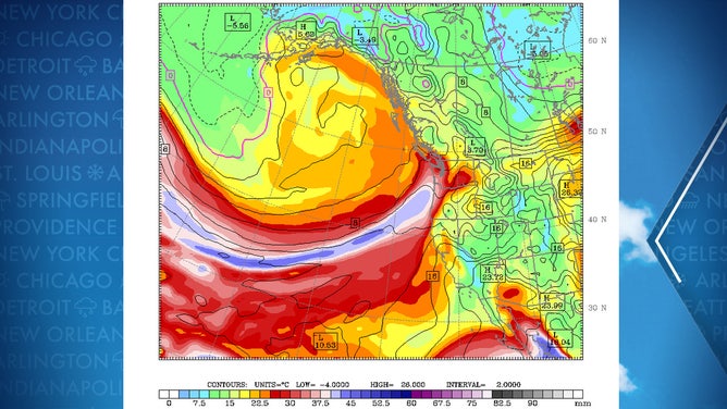
Water vapor forecast chart showing an atmospheric river aiming for the West Coast.
(University of Washington Atmospheric Sciences)
"They can temporarily stall in place, change their landfall locations, intensify or weaken, interact with other ARs (atmospheric rivers) or remnants of previous ARs, and warm or cool," according to the CW3E. "Any of those outcomes can affect AR impacts and can change with short notice."
The CW3E now dedicates an entire site to predicting the likelihood of an atmospheric river and where it's expected to have its most significant impacts.
Not all atmospheric rivers are bad news
Rain from atmospheric rivers can cause damaging flooding and mudslides, but they also serve an essential purpose in supplying much of the West's water supply – especially in California.
HOW TO WATCH FOX WEATHER ON TV
Weaker atmospheric rivers that bring copious amounts of rain but not enough to flood are considered beneficial to the area. About half of California’s annual rainfall comes from atmospheric rivers, and without them, the region can find itself in an extended drought.
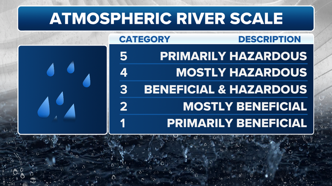
Atmospheric River Scale
(FOX Weather)
Forecasters have been working to measure atmospheric rivers better and convey their impacts to the public by creating a five-point scale.
WHAT DOES A CATEGORY 5 ATMOSPHERIC RIVER MEAN?
The scale aims to delineate between beneficial atmospheric rivers and those that cause more harm than good.