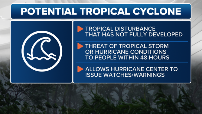
What is a potential tropical cyclone?
The National Hurricane Center issues routine advisories for potential tropical cyclones, just as it does for Atlantic hurricanes.
What is a potential tropical cyclone?
Explainer on potential tropical cyclones.
Tropical depression, tropical storm and hurricane are terms you hear every hurricane season, but the term "potential tropical cyclone" is a relatively new phrase with which you might not be very familiar.
Introduced by the National Hurricane Center (NHC) in 2017, a potential tropical cyclone permits the NHC to issue routine advisories on a system that has not yet developed into a tropical depression or tropical storm but brings a threat of 39-plus-mph winds to land within 72 hours.
HOW TO GET READY FOR A HURRICANE
This allows the NHC to issue Tropical Storm or Hurricane Watches and Hurricane Warnings with additional lead time, providing at-risk people with more advance notice of potential impacts and damage in their area.
HURRICANE, TROPICAL STORM WATCH VS. WARNING: WHY IT'S IMPORTANT TO KNOW THE DIFFERENCE
Information on what a potential tropical cyclone is.
(FOX Weather)
Prior to 2025, the NHC could not designate a system as a potential tropical cyclone until the threat of tropical storm or hurricane conditions was within 48 hours of occurring.
"This year, we'll be able to extend that lead time for getting those forecasts out as much as 72 hours in advance of the onset of hazard," NHC Director Michael Brennan told FOX Weather. "So, we're really going to be targeting those higher impact, higher confidence scenarios where we expect life-threatening storm surge inundation, damaging hurricane-force winds. That'll allow us to get those forecasts out sooner."
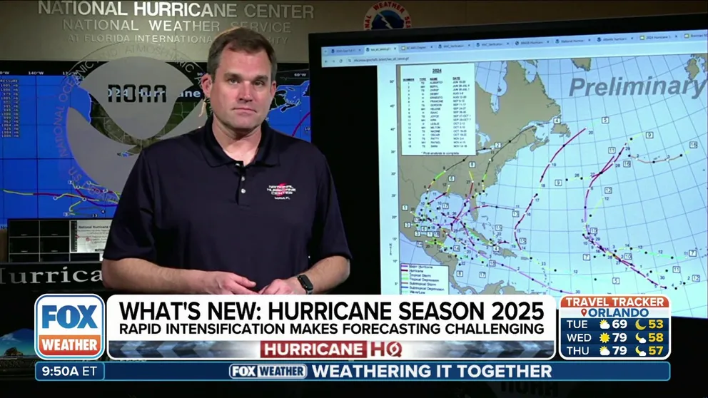
National Hurricane Center Director looks back at 2024 hurricane season, shares preview about 2025 season
Michael Brennan, the director of NOAA's National Hurricane Center, spoke about the latest changes the NHC will implement regarding Potential Tropical Cyclones and the agency's advisories to the public. He also covered the NHC's review of forecasting storms in 2024.
This change builds upon others the NHC has made in the past. In fact, before the era of a 48-hour lead time, the NHC could not issue any watches or warnings until a system had developed into at least a tropical depression.
"Advances in forecasting over the past decade or so ... now allow the confident prediction of tropical cyclone impacts while these systems are still in the developmental stage," the NHC said.
For example, on June 2, 2022, the NHC began issuing advisories, watches and warnings for Potential Tropical Cyclone One, which was forecast to become Tropical Storm Alex and bring heavy rain and gusty winds to portions of Florida.
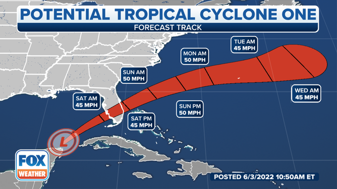
The forecast cone issued by the National Hurricane Center for Potential Tropical Cyclone One on the morning of June 3, 2022.
(FOX Weather)
The NHC publishes a forecast cone and a full suite of text, graphical and watch/warning products every six hours for all potential tropical cyclones, just as it does for hurricanes and tropical storms.
These updates occur at 5 a.m., 11 a.m., 5 p.m. and 11 p.m. EDT. When watches or warnings are in effect for any land areas, which is almost always the case with potential tropical cyclones, the NHC also provides additional updates at the three-hour intervals between those times.
WHAT IS THE ‘CONE OF UNCERTAINTY’ IN HURRICANE FORECASTS?
"Advisory packages on potential tropical cyclones will be issued until watches or warnings are discontinued or until the threat of tropical-storm-force winds (39 to 73 mph) for land area sufficiently diminishes, at which point advisories would be discontinued," the NHC said. "However, if it seems likely that new watches or warnings would be necessary within a short period of time (say 6-12 hours), then advisories could continue for a short time in the interest of service continuity."
The same naming conventions currently in place for tropical depressions, which are assigned a number from a chronological list, are used for potential tropical cyclones. That number always corresponds with the total number of systems that have occurred so far during the hurricane season.
For example, if the NHC had already issued tropical weather advisories on eight systems in the Atlantic Basin that year, the next land-threatening system in the Atlantic would be deemed Potential Tropical Cyclone Nine. If it eventually organized into a tropical depression, it would retain the same number and become Tropical Depression Nine. Then, if it achieved 39-plus-mph winds, the system would become a tropical storm and earn the ninth name on that year’s name list, which would be the "I" storm.
BEWARE THE ‘I’ STORM: IT HAS MORE RETIREES THAN ANY OTHER LETTER USED FOR ATLANTIC HURRICANE NAMES
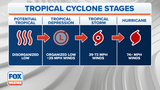
The different stages of a tropical cyclone are displayed in this infographic.
(FOX Weather)
The only hiccup in this naming convention would be if Potential Tropical Cyclone Ten or Tropical Depression Ten became a tropical storm before Potential Tropical Cyclone Nine or Tropical Depression Nine. In this case, Ten would earn the "I" name while Nine would earn the "J" name because Ten became a tropical storm first even though Nine existed first.