Live updates: Brewing winter storm targets millions across America as fire threat rages in Florida
A new winter storm system takes aim on the Midwest and Northeast, threatening millions with heavy snow and travel disruptions just days after a historic Northeast blizzard. Meanwhile, critical fire danger and Fire Weather Warnings grip Central and South Florida today as record warmth, low humidity, and gusty winds create tinderbox conditions.
Coverage for this event has ended.
LIVE coverage has ended here, but FOX Weather is your Winter Storm HQ, providing around-the-clock live coverage to help keep your family safe.
The National Weather Service in Miami is warning drivers to be cautious of super fog due to the National Fire that is currently burning in South Florida.
Super fog is a mixture of smoke and moisture, with the moisture being released from damp smoldering material. Visibility is dramatically lowered to less than 10 feet when super fog is present, according to the FOX Forecast Center.
The National Fire continues to burn just south of Alligator Alley in Collier County, with a smaller fire, called the Regal Fire, also burning east of State Route 29 along Tamiami Trial.
Fog will be visible over a large portion of south Florida overnight until about 9 a.m. Friday.
Drivers should beware that super fog can cause extremely dangerous driving conditions during this time.
Providence police are asking people to heed the parking ban that remains in effect as crews work to clear snow from this week's historic blizzard.
The police department said officers are deployed across the city supporting snow operations and helping ensure plows can move quickly and safely through Providence.
"Our officers are actively enforcing the parking ban, assisting with disabled vehicles and keeping travel lanes clear so DPW crews can do their work without delays," police said on social media.
Authorities say you can help by keeping cars off the street and avoiding unnecessary travel while cleanup continues.
Rhode Island State Police is urging people to use caution because as melting snow refreezes, roads may be slippery.
Troopers said lanes or ramps may close due to black ice.

"Please slow down, follow posted directions and give first responders space to work safely," police said on social media.
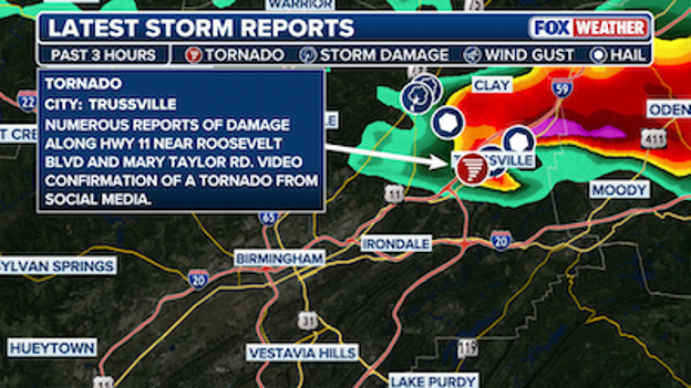
The National Weather Service receives numerous reports of damage due to possible tornado.
Despite there being no Tornado Warning issued, there appears to be tornado damage in Birmingham, Alabama.
The National Weather Service in Birmingham has received numerous reports of damage along Highway 11 near Roosevelt Boulevard and Mary Taylor Road.
The FOX Forecast Center confirms that there's debris signatures that indicate a tornado may have passed through the area in the past three hours.
There is a Thunderstorm Warning in effect for the area through 5:30 p.m. CT.

Firefighters use a rescue harness to bring one of the people trapped on the USS Laffey to safety.
Crews rescued 30 people trapped on the USS Laffey after the walkway between the boat and the pier collapsed into the water.
Mount Pleasant Fire Department Battalion Chief Matthew Tidwell said they were called to the area around 2:45 p.m. to assist with a rescue.
They learned that the walkway, also known as a gangway, between the pier and the boat collapsed. The gangway is how people get on and off the boat, according to Tidwell.
Officials are unsure how it happened, but it was a bit windy in the area at the time.
The collapse happened while the area saw some wind gusts up to 25 mph, according to the FOX Forecast Center.

No one was on the gateway when the collapse happened, but 30 people were stuck on the boat as a result.
Firefighters set up an aerial ladder to help the people stuck on the boat, and a rescue harness was used to get one of the people rescued to safety.
No injuries were reported, and officials say this was the best case scenario given the circumstances.
The USS Laffey is a World War II destroyer that visitors can tour.
Three cities in Texas recorded temperatures in the triple digits today.
The FOX Forecast Center said Zapata, Cotulla and Carizzo Springs all reached 100 degrees.
Zapata reached 102 degrees, Cotulla reached 101 degrees and Carrizo Springs reached 100 degrees.
The FOX Forecast Center has confirmed that temperatures in Laredo reached 100°F this afternoon, marking the first time in 2026 that triple digits have been recorded anywhere in the United States.
This isn't just unusually warm—it is potentially historic. Laredo's thermometers are soaring toward the all-time U.S. record for the hottest temperature ever recorded during the winter months, which stands at 104°F.
Forecasters are monitoring parts of Alabama and Mississippi for severe storms this afternoon.
The FOX Forecast Center is keeping a close watch on a cold front sagging south of the Tennessee border, which is expected to fire up thunderstorms this afternoon.
The Storm Prediction Center says there's a 60% chance it will issue a Severe Thunderstorm Watch for portions of Alabama and Mississippi.
Right now, abundant sunshine is heating up the atmosphere across the region. As temperatures heat up, forecasters are tracking a steady increase in CAPE.
CAPE is a measurement of "fuel" in the atmosphere; it stands for Convective Available Potential Energy, and it tells us how much energy is available for a storm to grow vertically.
While it's warm at the surface, temperatures high in the atmosphere are quite cool. This temperature difference helps air rise quickly, which is a key ingredient for storm development.
As these storms develop over the next few hours, the main concern will be large hail. Strong winds high in the atmosphere are creating significant shear—which is a change in wind speed or direction with height. This shear helps organize storms into supercells, which are highly organized, rotating thunderstorms that are notorious for producing large chunks of ice.
Fortunately, the risk for tornadoes currently looks very low, as the winds closer to the ground aren't showing that same "spinning" energy, but a few storms could produce localized downbursts—sudden, powerful blasts of wind that hit the ground and spread out—as the evening progresses.

Remember to download the FOX Weather App handy for critical weather alerts.
And, if you have a safe view of the weather as it rolls through, use our "See It, Share It" tool to help us track the storms. You can upload your photos and videos at foxweather.com/connect.
The Alamo City is feeling a summer-strength punch today. Temperatures in San Antonio have soared to 93°F, marking the city's hottest February day in 30 years.
This unusual heat is part of a trend that has made this winter the 4th warmest for the city. While today's 93°F is exceptionally rare for late February, it hasn't quite toppled the all-time monthly record of 100°F. That triple-digit scorcher occurred on February 21, 1996—exactly 30 years ago this week.
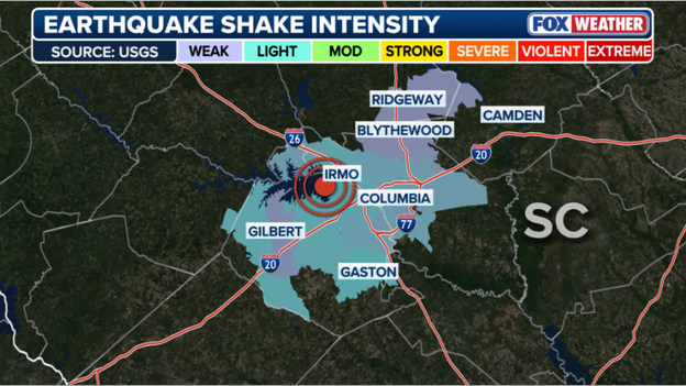
A graphic from the FOX Forecast Center shows what cities and towns felt the earthquake that rattled parts of South Carolina on Thursday.
A graphic from the FOX Forecast Center shows what cities and towns felt the earthquake that rattled parts of South Carolina on Thursday.
Towns including Columbia and Gaston felt light shaking, while areas including Ridgeway, Blythewood and Gilbert felt weak shaking.
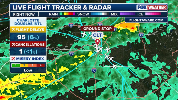
FlightAware reports nearly 100 flights in and out of Charlotte have been delayed so far today.
If you are traveling through the Queen City today, keep a close eye on the departure boards.
Charlotte Douglas International Airport (CLT) is currently grappling with a ground stop due to thunderstorms in the region.
A ground stop is an air traffic control measure that keeps planes on the ground at their departure airports because of conditions—like severe weather—at their destination. Flights destined to Charlotte cannot takeoff until the ground stop is lifted.
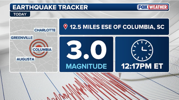
A magnitude 3.0 earthquake shook South Carolina on Thursday afternoon.
The Midlands of South Carolina felt the ground shake this afternoon as a magnitude 3.0 earthquake struck near Lake Murray and Irmo.
The U.S. Geological Survey (USGS)—the federal agency responsible for monitoring and providing data on earthquakes and other natural hazards—reports that the tremor hit around 12:17 p.m. ET.
The preliminary location of the quake was centered near the Lake Murray dam, south of Yacht Cove and near North Lake Drive.
This area has seen an unusual cluster of seismic activity recently, with today’s event marking at least the third earthquake in the Irmo area this month.
In the first 30 minutes following the shake, more than 250 people used the USGS online reporting tool to confirm they felt it. Those reports came in from Columbia to the east and as far south as Red Bank.
Similar to other recent quakes in the Midlands, residents described the event as a loud noise—often sounding like an explosion, a door slamming, or even lightning striking the house.
While specific depth data is still being refined by seismologists, earthquakes in this region are often quite shallow, which can make them feel much more intense to those living near the epicenter—the point on the Earth's surface directly above where the quake originated.
Experts say that while these tremors are startling, a magnitude 3.0 earthquake is considered "minor," meaning it is typically felt by many but rarely causes significant damage.
Local geologists and the South Carolina Emergency Management Division (SCEMD)—the state agency in charge of emergency preparedness and response—continue to monitor the area for any patterns.
Despite the proximity to the Lake Murray dam, experts have previously stated that these small earthquakes are well below the threshold of impact that would cause structural concerns for the dam.
If you felt the earth move today, we encourage you to use our "See It, Share It" tool to help us tell the story. You can navigate to foxweather.com/connect to share your experiences or any photos with the FOX Weather team.

The FOX Forecast Center is tracking a new winter storm that is expected to drop snow from the Midwest to the Northeast.
- New winter storm threat: A winter storm is expected to develop over the Northern High Plains, projected to bring "plowable" snow and ice to the Mid-Mississippi Valley, Ohio Valley, and Mid-Atlantic starting on Sunday.
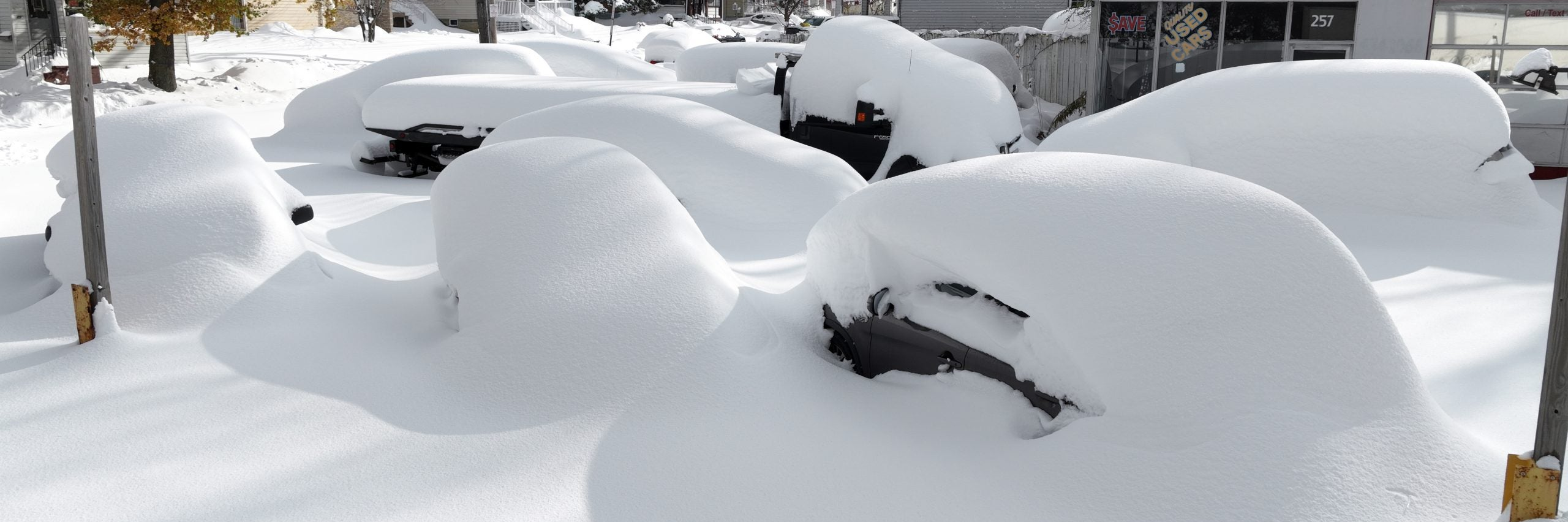
- Historic blizzard recovery: Emergency crews in the Northeast continue to clear massive drifts after Providence, RI recorded a staggering 37.9 inches of snow—the most ever recorded in state history.
- Florida fire alert: A Fire Weather Warning is in effect today for Central Florida, including Orlando. Outdoor burning is strictly prohibited as humidity drops to 20% and temperatures climb into the low 80s.
- 'Alligator Alley' shut down: Thick smoke from the National Fire burning in South Florida closed a huge stretch of Interstate 75 overnight.
- Record warmth in the Plains: Numerous record high temperatures are expected to fall today across the Southwest and Southern Plains, with some areas in Texas and the Desert Southwest hitting the 90s.
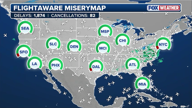
FlightAware MiseryMap showing where flight disruptions are impacting major U.S. airport hubs.
If you are heading to the airport today, you might want to double-check your flight status. While the country is still shaking off the remnants of a historic blizzard, new weather challenges are cropping up from coast to coast.
The FAA is currently managing several "ground delay programs"—which are formal traffic management initiatives that hold aircraft at their departure airports to regulate the flow of traffic into congested or weather-impacted hubs.
It's a combination of gusty winds and low cloud ceilings that is creating a bottleneck at some of the nation’s busiest airports.
- Palm Beach (PBI): Winds are slowing things down enough so that a Ground Stop has been issued until 1:00 p.m. ET. That means flights destined for Palm Beach aren't allowed to takeoff until the stop is lifted.
- San Francisco (SFO): Low ceilings—an aviation term for low-hanging cloud layers that restrict visibility—are forcing air traffic controllers to slow down arrival rates for safety. A Ground Stop is in effect until 1:15 p.m. ET.
- Dallas-Fort Worth (DFW): Flights in and out of North Texas are subject to 30 minute delays due to low clouds.
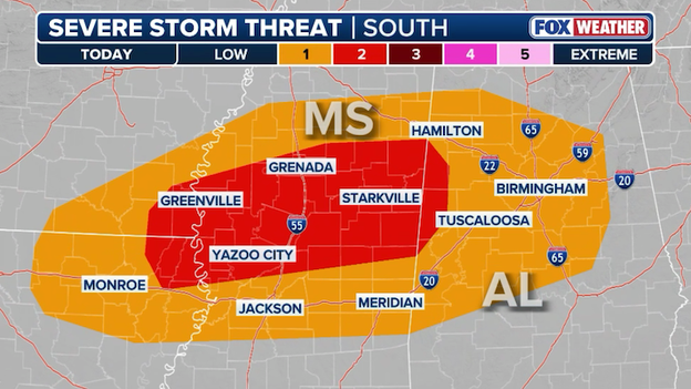
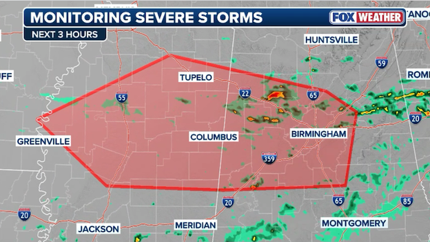
A Level 2 of 5 severe storm threat is in place for portions of the Deep South this afternoon.
While we have been closely tracking winter weather in the north, our focus is shifting to the Gulf States as the threat of severe weather increases today.
The FOX Forecast Center is monitoring a cold front—a weather "border" between two different air masses—that is slowly sagging toward the Gulf Coast and the northern Florida peninsula.
The atmosphere is currently unstable enough to support isolated severe thunderstorms, which are storms capable of producing damaging winds or hail. Because of this, a Level 2 out of 5 threat has been introduced for parts of the region.
Right now, the greatest focus for these developing storms will be across Mississippi and Alabama.
Some of the storms could be strong enough to produce quarter-size hail as they move through during the peak heating of the afternoon.
If you are in the path of these storms, remember to use our "See It, Share It" tool. If you have a safe vantage point, you can visit foxweather.com/connect to upload your photos and videos. And download the FOX Weather App to enable critical weather alerts wherever you go.
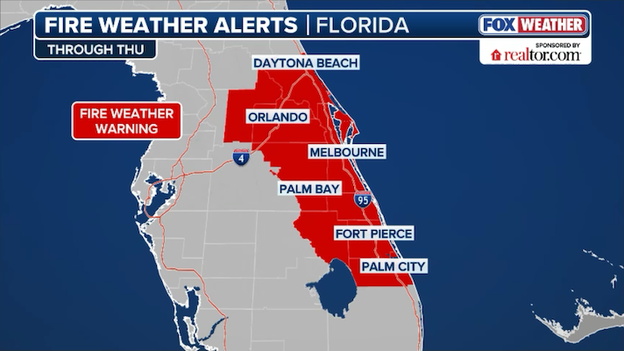
Fire Weather Warnings now span across Central Florida and along the state's Atlantic coast.
The National Weather Service just expanded its Fire Weather Warning (also known as a Red Flag Warning) across a massive portion of Central Florida.
The warning now includes Southern Brevard, Indian River, St Lucie, Martin, and Okeechobee Counties through the afternoon.
A volatile mix of southwest winds gusting up to 25 mph and humidity levels dropping as low as 30% means that any small spark could rapidly escalate into an uncontrollable blaze.
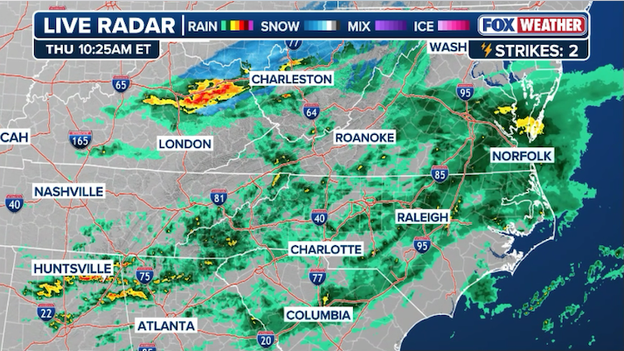
Radar showing widespread rain and a few thunderstorms across the Southeast right now.
A cold front is the main weather story for the Gulf States and Southeast today, bringing much-needed rain but also the risk of isolated thunderstorms.
The FOX Forecast Center is tracking a weak boundary that is expected to sag slowly toward the Gulf Coast and northern Florida peninsula through the end of the week.
While a widespread severe weather outbreak is not expected, the atmosphere is just unstable enough to support isolated severe thunderstorms.
Isolated to scattered thunderstorms will roll through the Gulf states, with a particular focus on Mississippi and Alabama. These areas could see a few storms capable of producing small hail this afternoon.
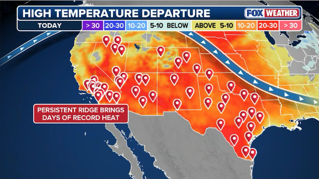
A ridge of high pressure will send temperatures soaring across the Southeast this afternoon.
While much of the country is still shaking off the remnants of a historic blizzard, a staggering heat wave is currently erupting in Deep South Texas.
The FOX Forecast Center is warning that temperatures in the Rio Grande Valley are likely to soar into the triple digits today, marking the first time in 2026 that 100°F has been recorded anywhere in the United States.
This isn't just unusually warm—it is potentially historic. FOX Weather meteorologists are keeping a close watch on the thermometers as some areas approach the all-time U.S. record for the hottest temperature ever recorded during the winter months, which stands at 104°F.
The combination of a powerful high-pressure ridge and dry, downslope winds has turned the border region into a late-February furnace. Cities like McAllen, Brownsville, and Rio Grande City are in the bullseye of this heat spike, which is occurring weeks before the official start of spring.
The extreme heat is significantly heightening the fire risk across South Texas, as the triple-digit temperatures rapidly dry out any remaining surface moisture.
Residents are being urged to stay hydrated and limit outdoor activity during the peak afternoon hours. While a cold front is expected to bring a gradual cooldown by the weekend, today’s winter sun is packing a summer-strength punch that could rewrite the record books.
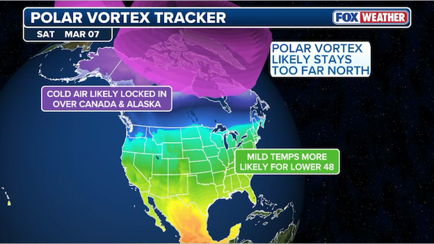
While we typically associate the Polar Vortex with bone-chilling Arctic outbreaks, a rare atmospheric phenomenon is currently unfolding that may actually lead to a surprising spring-like surge for millions.
The FOX Forecast Center is monitoring a major Sudden Stratospheric Warming Event (SSWE)—a rapid spike in temperature miles above the Earth’s surface—that has caused the Polar Vortex to weaken and split into two distinct lobes.
Remarkably, this is the second time this season such an event has occurred. Since major warming events typically only happen once every other year, witnessing two in a single winter is a once-in-a-decade rarity.
The split of the vortex usually signals a southward spill of Arctic air, but the current positioning is playing a different hand. Projections for the first half of March show the core of the coldest air remaining anchored over Canada and Alaska.
Because of this specific alignment, a massive high-pressure ridge is expected to build over the Lower 48. This blocking pattern essentially stalls the weather, allowing stable, milder air to dominate the United States.
In a paradoxical twist, the shattered Polar Vortex is currently acting as a shield against winter’s return rather than a gateway for it.
A springlike warmup is on track to send temperatures surging across America in March.
NOAA's Climate Prediction Center is already leaning into this signal, with its temperature outlook for the second week of March showing a high probability of above-average temperatures for the entire Lower 48. The most significant warmth is expected to settle east of the Rockies.
However, FOX Weather meteorologists warn against packing away the winter coats just yet. There is a notorious lag time with these stratospheric events; it can take four to six weeks for the changes in the upper atmosphere to fully "sink" down to the surface where we feel them.
This means that while early March looks exceptionally mild, the delayed effects of this split could potentially trigger a late-season cold snap as we head into April.
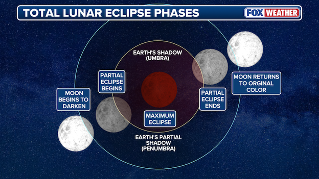
On Tuesday, March 3, the Moon will pass through Earth's inner shadow.
While winter storms and fire threats dominate the headlines, NASA is looking toward the skies as a Total Lunar Eclipse prepares to grace the early morning of Tuesday, March 3.
This celestial event, often called a "Blood Moon," will see the Moon pass entirely through Earth's inner shadow, turning the lunar surface a dramatic coppery red. Unlike solar eclipses, this event is perfectly safe to view with the naked eye and requires no special filters.
For observers in America, the show begins in the pre-dawn hours. The "partial" phase—where it looks like a bite is being taken out of the Moon—starts at 4:50 a.m. ET (1:50 a.m. PT). The main event, totality, begins at 6:04 a.m. ET (3:04 a.m. PT) and will last for approximately one hour.
According to NASA, during this time, the Moon will be positioned in the constellation Leo, making it a prime opportunity for backyard astronomers to spot deep-space constellations that are usually washed out by the glare of a full Moon.
The "Blood" effect: The red tint is caused by Earth's atmosphere scattering sunlight; essentially, you are seeing the light of every sunrise and sunset on Earth projected onto the lunar surface at once.
Visibility: Totality will be visible across North and Central America, the Pacific, and parts of Eastern Asia and Australia.
Viewing tip: While binoculars enhance the craters, the best way to see the deep red color is simply to find a dark spot away from city lights.
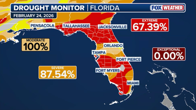
U.S. Drought Monitor showing XX% of Florida now enduring 'extreme' drought conditions.
While Florida residents spent the fall of 2025 breathing a sigh of relief as hurricane after hurricane steered away from the coastline, the state is now paying a hidden price for that "good luck."
In the world of Florida hydrology, tropical systems are more than just destructive storms; they are essential drought-busters that provide the massive, multi-day soaking required to recharge deep aquifers.
Because the 2025 Atlantic hurricane season was largely a "miss" for the Florida peninsula—marked by a persistent high-pressure ridge and a northern-displaced jet stream—the state entered its current dry season with a staggering rain deficit of up to 20 inches in some regions.
The lack of tropical activity has essentially broken the natural cycle that Florida relies on to survive its winter months.
Typically, a single tropical depression or weak tropical storm in September or October acts as a massive deposit into the state's water bank, saturating the soil and filling the Biscayne and Floridan aquifers to their peak levels.
Without those organized systems to provide widespread, heavy precipitation, the state was forced to rely on hit-or-miss afternoon thunderstorms, which were insufficient to offset the intense evaporation caused by record-breaking summer heat.
Consequently, areas like Tallahassee and South Florida began 2026 with groundwater levels that were already at critical or record-low markers.
This hydrological shortfall is the direct engine behind the dangerous fire conditions being witnessed today. In a normal year, Florida's wet season (late May through early October) provides enough moisture to keep the state's vast cypress swamps and pine flatwoods damp well into the spring.

However, because the 2025 recharge never happened, the vegetation has transformed into ready-made fuel months earlier than usual.
Firefighters are now warning that the state is facing its most significant wildfire threat in over 25 years—a paradoxical consequence of a hurricane season that was, by all other accounts, a blessing.
As the weak La Niña continues to block most rain-bearing fronts from reaching the peninsula, Floridians find themselves in a precarious position: waiting for the very rain that they once feared.
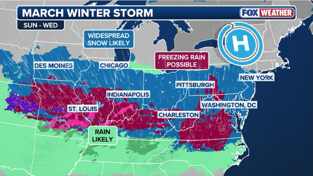
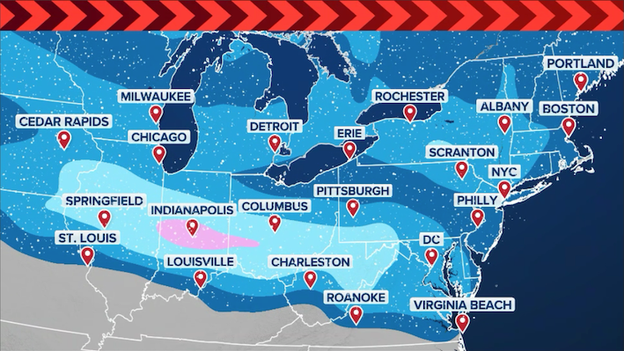
A complex, multi-day winter storm will take aim on the Midwest and Northeast this weekend with snow and ice.
As the Northeast continues the massive cleanup from the historic Blizzard of 2026, the FOX Forecast Center is now tracking a complex, multi-day winter threat set to sweep from the Midwest to the Atlantic coast.
This evolving system is expected to arrive in two distinct waves beginning Sunday and lasting through Wednesday, potentially impacting more than two dozen states with a volatile mix of heavy snow, sleet, and dangerous ice.
While the bones of a major storm are present, meteorologists are closely watching a high-stakes atmospheric tug-of-war that will determine whether major cities see a winter wonderland or a treacherous ice rink.
The first wave of energy is slated to ignite in the Midwest on Sunday before sliding into the I-95 corridor by Monday morning, followed by a second, more focused surge hitting the Northeast and Mid-Atlantic on Tuesday.
The primary engine behind this storm is a process known as "overrunning," where warm, moisture-rich air from the south climbs over a dense dome of cold air locked at the surface.
The severity of the impact hinges on the strength of a disturbance moving along the northern jet stream. A stronger, more amplified ripple—as suggested by the GFS model—would mean heavier snow and broader reach, while a flatter, weaker disturbance favored by the ECMWF model would result in lighter precipitation and a lower overall impact.
Perhaps the most critical variable for commuters is the depth of the cold air residing over the Great Lakes and Northeast. For a high-impact snowstorm, the atmosphere must remain freezing from the clouds all the way to the ground. If that cold layer is too shallow, snowflakes will melt into rain or sleet aloft, creating a messy scenario rather than a clean snow event.
Current high-end projections suggest a swath of 5 to 8 inches of snow stretching from the Ohio Valley to the I-95 corridor, while low-end scenarios lean toward a 1-to-3-inch event plagued by mixing.
For those in the transition zone—currently centered along the I-70 corridor and the Ohio River Valley—ice is the primary concern. This narrow band marks the volatile border where freezing rain and sleet could cause significant travel disruptions and power outages.
Because even a slight shift of 50 miles north or south could be the difference between a plowable snow and a damaging ice glaze, residents from Chicago to D.C. to New York are urged to monitor updates closely as the fine-scale details of this March storm continue to settle.

While much of the northern United States is focused on the aftermath of a historic blizzard, Florida is currently facing a "tinderbox" scenario as extreme drought and dangerous fire weather converge.
The National Weather Service in Melbourne has issued a Fire Weather Warning, also known as a Red Flag Warning, effective from 1:00 p.m. to 6:00 p.m. ET today, covering a massive swath of Central Florida including Orange, Seminole, Lake, Volusia, Osceola, and Northern Brevard counties.
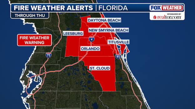
A Fire Weather Warning is in effect for Central Florida this afternoon due to gusty winds and dry air.
FOX Forecast Center meteorologists are warning that any spark today could rapidly escalate into an uncontrollable blaze due to a volatile combination of southwest winds gusting up to 25 mph and relative humidity levels plummeting as low as 30%.
The threat is compounded by a worsening drought crisis, as the U.S. Drought Monitor reports that 67% of the state is now gripped by extreme drought.
This lack of moisture has turned vast areas of vegetation into ready-to-burn fuel, leading several counties—including Volusia, Polk, and Sumter—to enact strict outdoor burn bans.
In South Florida, the situation is already critical; firefighters are currently battling the National Fire in Big Cypress National Preserve, a brush fire that has scorched thousands of acres and forced the closure of sections of Alligator Alley (I-75) due to dense, vision-obscuring smoke.
Residents across the Sunshine State are being urged to exercise extreme caution with any activity that could cause a spark, from lawn mowing to discarding cigarettes.
While a cold front is expected to bring showers starting late Friday and continuing into Saturday, it won't suddenly end the drought.
See how the day's top weather news evolved with our LIVE coverage from Wednesday.
Live Coverage begins here