UPDATES: Potentially historic nor'easter bringing snow, wind, flooding to Northeast
More than 76 million Americans are in the path of a blockbuster winter storm this weekend from New England to the Mid-Atlantic. The track of this storm will make a big difference between whether you'll see two inches of snow or 20.
Coverage for this event has ended.
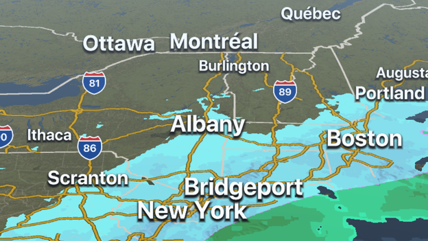
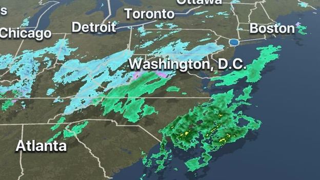
Heavy snow is now falling over portions of the Northeast. FOX Weather's 3D radar is tracking the bands moving into New Jersey and areas to the north. Download the FOX Weather app now to stay ahead of the winter weather.
Apple Store download: Click Here
Google Play Store download: Click Here
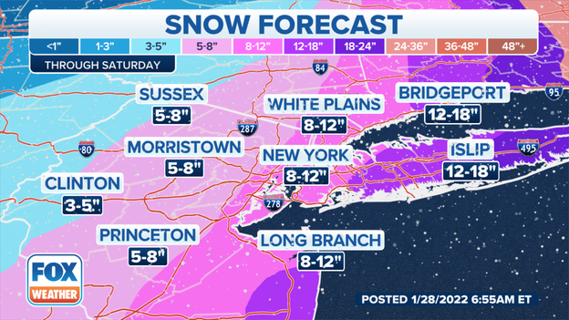
Snow is falling in New York City and before all is said and done upwards of a foot could fall in the metro area. The heaviest snowfall is expected to be over eastern Long Island, where more than a foot of frozen precipitation could fall. Areas to the west and away from the coastline will see considerably less snow.
Latest forecast: Click Here
Parts of Long Island are forecast to see a foot of snow. The flakes started falling on southern New York on Friday and is expected to continue into Saturday.
Latest forecast: Click Here
The system that will bring feet of snow to parts of New England, as well as wind gusts to near-hurricane force, is intensifying in the warmer than average waters of the Atlantic. Satellites from 22,500 miles above Earth's surface are not only seeing the heavy cloud cover but also lightning.
Latest forecast: Click Here
Meteorologists warn heavy snow will develop along the northern mid-Atlantic coast overnight. Snowfall rates greater than 1" per hour will likely impact the southern New Jersey coast and Long Island by midnight.
Track the snow on the FOX Weather app: Click Here
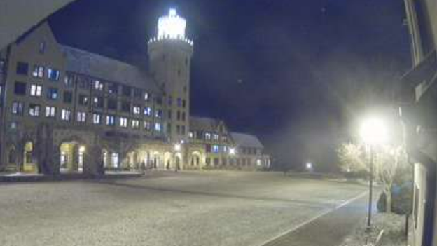
Light snow is being reported in northern Georgia. Meteorologists say Lookout Mountain at Covenant College could pick up on upwards of half an inch of frozen precipitation overnight.
Track the snow on the FOX Weather 3D Radar: Click here to download
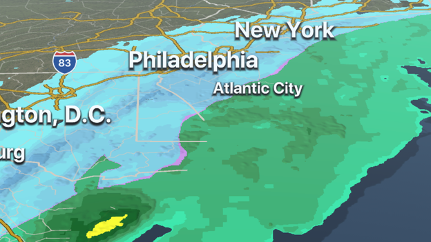
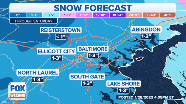
Forecast models show the metro Baltimore region will miss out on the heaviest snow. The area is expected to see upwards of 3 inches through Saturday.
Updated forecast on the incoming blizzard: Click Here
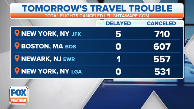
At least 3,126 flights were canceled with destinations either into or out of the U.S. on Saturday, FlightAware reports.
Some of the cities with the largest amounts of cancellations include: John F. Kennedy International, Boston Logan International and Philadelphia International.
Why officials are saying stay off the roads: Click Here
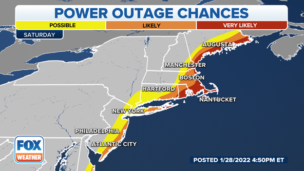
The combination of frozen precipitation and wind is expected to bring down power lines in areas of the Mid-Atlantic and Northeast.
Coastal parts of New England have the highest chances for seeing power outages. Why 10 million Americans face the threat of losing power: Click Here
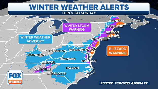
More Americans are now under winter weather alerts from the Mid-Atlantic into New England.
-Blizzard Warnings cover 10.7 million people
-Winter Storm Warnings cover 31 million people
-Winter Weather Advisory cover 36.1 million people
What makes a blizzard different than an ordinary snowstorm: Click Here
The FOX Weather 3D Radar is tracking the storm system forming off the East Coast. Before heavy snow starts falling along the I-95 corridor, download the free app to track the snow in your area.
Apple Store download: Click Here
Google Play Store download: Click Here
Amtrak says they’ve canceled all regional service between Boston and New York because of the impending storm. Many of the areas between the cities are under winter weather alerts.
Several other travel companies have also announced delays and cancellations: Click Here
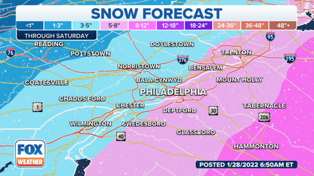
Snowfall totals will vary greatly in the Philadelphia metro region because of the nor'easter's trajectory. Areas to the north and west of the city are expected to pick up on less than 5" of snow. Suburbs to the south and east of downtown could pick up on substantially more. Forecast models show around of foot of snow is possible along the Pennsylvania-New Jersey state line.
Nor'easter forecast: Click Here
Blizzard Warnings stretch for more than 700 miles along the East Coast.
Governor Phil Murphy declared that New Jersey will enter a state of emergency effective at 5 p.m., in preparation for a winter storm forecast to impact the state this weekend.
The order applied across all 21 counties in the state, allowing resources to be deployed during the duration of the storm. Commercial vehicle restrictions will also be in place on multiple interstate highways.
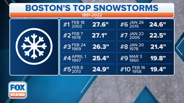
Historic snow is possible in Boston, where a crippling 2-plus feet could potentially fall, making it one of the biggest snowstorms on record.
While that is on the high end, it's certainly not out of the question for at least parts of the metro area. If Boston picks up more than 19.4 inches of snow, it will make the list of the city's 10 biggest snowstorms.
Here's when you need to be prepared to hunker down in each of these major cities as the storm develops off the East Coast.
New Jersey Governor Phil Murphy holds a winter storm briefing to give an update on the state's preparations in advance of this weekend’s major nor'easter.
Boston Mayor Michelle Wu holds a press conference to give an update on the city’s preparations in advance of this weekend’s major nor'easter. (Video Credit: WFXT Boston 25 News)
Live Coverage begins here
