WEATHER WIRE: More than 100 million Americans in path of winter storm's snow, ice through Friday
Snow and ice will expand from the Southern Plains to the Midwest and Northeast through Friday
Coverage for this event has ended.
Connecticut Governor Ned Lamont announced the closure of all state office buildings closed on Friday, due to the winter storm.
Forecast models show that northern parts of the state could see upwards of a foot of snow.
Latest Forecast: Click Here
Airlines across the U.S. have already canceled 2,207 flights Friday according to FlightAware.com. The majority of the canceled flights were heading to and from airports in the Northeast.
Friday cancelations:
Boston Logan International Airport - 520
Newark Liberty Airport (NJ) - 179
LaGuardia Airport (NY) - 141
Reagan Washington National Airport - 105
On Thursday, airlines canceled 3,699 flights and 5,518 flights were delayed.
The storm will spread freezing rain, sleet and snow across much of Pennsylvania. Pennsylvania Department of Transportation, Alexis Campbell told FOX Weather that her biggest concern is ice.
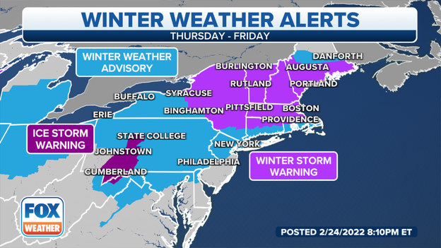
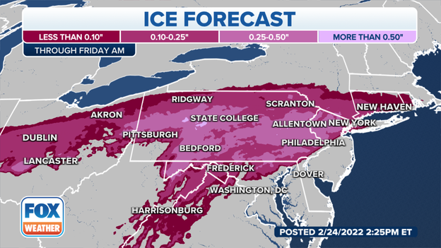
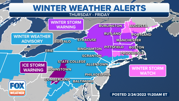
The National Weather Service issued an Ice Storm Warning for the mountainous west-central portion of the estate until 10 a.m. local time. A quarter to a half-inch of ice could accumulate on surfaces.
The Pennsylvania Turnpike implemented Tier 1 restrictions. The restrictions ban empty big-rigs, oversized loads, RVs, trailers and motorcycles. The speed limit dropped to 45 mph and commercial vehicles are only allowed in the right lane.
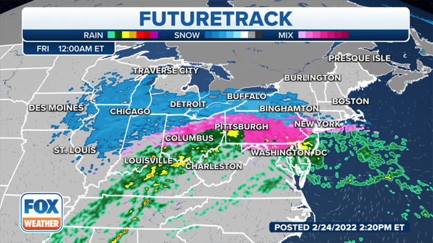
Snow pushes toward Western New York while an icy mix heads for Pennsylvania. The precipitation moves to the eastern seaboard late night through the early morning.
Snow mixes with freezing rain across Pennsylvania, New Jersey and downstate New York keeping down snow amounts. New England and Upstate New York will see all snow.
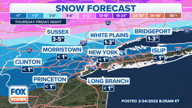
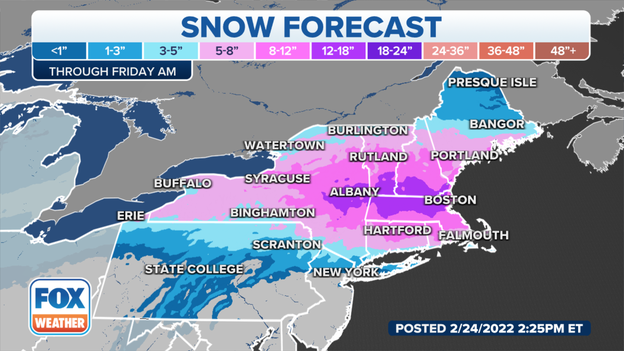
Snow forecast:
New York City - under an inch
Sussex County, NJ - 3-5"
Providence, RI - 5-8"
Boston - 8-12"
Albany, NY - 12-18"
FOX Weather has the latest road conditions from the Midwest to the Northeast.
Slush is quickly freezing over across Iowa and Missouri. Watch for icy patches. Detroit and Chicago will see snow through the overnight with only 1-4 inches expected by morning.
Washington will continue to see rain possibly mixing with sleet overnight while Philadelphia will see mainly rain. Snow moves into New York and mixes with freezing rain in time for the morning commute.
Boston will see all snow into Friday morning.
Altoona, Pennsylvania is dry right now but freezing rain moves in overnight. The National Weather Service issued an Ice Storm Warning until 10 a.m. local time on Friday.
The New York City Emergency Management Department issued a travel advisory for late Thursday through Friday. The city will see snow changing to an icy mix including freezing rain into early Friday.
DOT crews will work through the night to pre-treat and clear roads said the DOT Commissioner. But, he urges commuters to use mass transit. Over 700 salt-spreaders are filled and ready he said.
Winter weather alerts continue from the Canadian border, through the Mississippi River, into Texas and to the Atlantic. Over 100 million Americans saw or will see heavy rain, freezing rain and snow.
New Jersey's Public Service Electric and Gas Company said that they added extra personnel to the schedule to be ready for the freezing rain, sleet and snow heading for the state. The ice weighs down tree limbs and wires which can cause them to snap and take out power.
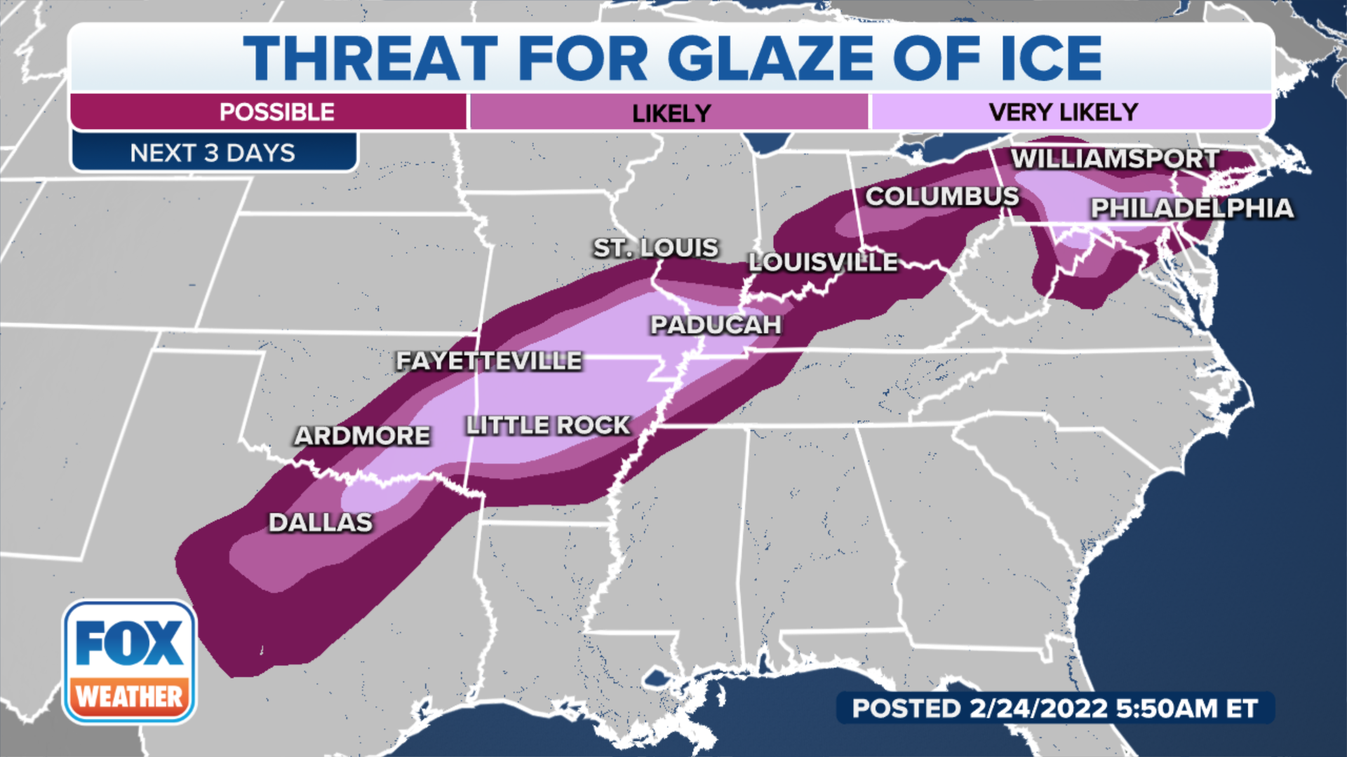
Northern New Jersey and much of Pennsylvania could see up to half an inch of ice by Friday morning.
HOW MUCH ICE IS NEEDED TO KNOW OUT POWER, DAMAGE TREES?
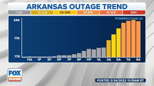
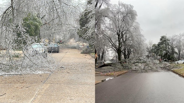
Homes and businesses across the South and Mid-south saw significant ice from this storm which knocked out power to homes and businesses.
Customers Without Power (according to PowerOutage.US)
Arkansas - 31, 508
Tennessee - 7,327
Texas - 4,537
Missouri - 2,506
Kentucky - 1,137
"Just because you go to bed and it looks like spring outside, when you wake up, it's going to be a very different world is going to feel much more like December Our advice is when you wake up, if you can work remotely, if you can stay off the roads that allows us to keep the roads clear. If you must drive, please take it slow and easy."
New York's Governor said in a press releasse that the state's emergency response assets are ready but warn residents that the snow and ice are on the way.
FurtureTrack shows Western New York getting snow before midnight. The New York Metro area and most of Pennsylvania will see an icy mix.
Up to a foot of snow could fall across New England warns the National Weather Service. The heaviest snow will fall during the morning commute from 7 a.m. to 3 p.m. The New Hampshire Department of Transportation urges everyone to delay travel if possible as snowfall rates could approach 1-2" of snow per hour.
Over half of all flights coming arriving or departing from the Dallas-Fort Worth International have been canceled due to this strong storm according to FlightAware.com.
Over 1,700 flights have already been canceled for Friday, most out of or into Boston Logan International Airport and Newark Liberty International Airport.
Officials are urging people to stay off the roads in Oklahoma as a winter storm continues to impact travel across the state on Thursday. FOX Weather Multimedia Journalist Hunter Davis is reporting on the icy conditions in Tulsa.
With subfreezing temperatures throughout most of Texas through Friday, state power regulators are expecting demand to be high.
However, ERCOT has not issued a notice for consumers to reduce their usage, as of Thursday morning.
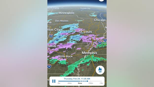
An area of showers and a few thunderstorms, accompanied by a wintry mix of precipitation, is now overspreading the Interstate 70 corridor from Illinois into Indiana. This includes periods of heavy sleet and snow, with snowfall rates occasionally reaching 1 inch or more per hour through Thursday afternoon.
FOX Weather's Will Nunley shared before and after images of a creek in Perry County, Tennessee. The creek has flooded covering a small bridge.
The above tweet shows what it looks like on a normal day. Here is what it looks like now. 😮
Images and video courtesy of K. Dumont.
Snow and some ice will reach the Northeast on Thursday night, which could be heavy at times.
The New York City tri-state area is predicted to see a period of snow late Thursday night that changes over to a wintry mix of freezing rain and sleet by Friday morning, though the precipitation should remain mostly snow overnight to the north and west across much of upstate New York and New England.
All of these areas can expect dangerous driving conditions from the snow and ice.
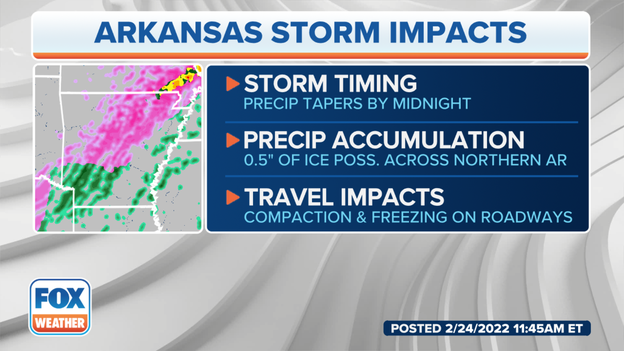
Sleet and freezing rain are predicted to continue into Thursday night in central and northern Arkansas before tapering off toward midnight. Some northern portions of the state might see up to a half-inch of ice accretion. Slippery roads are expected, in addition to tree damage and power outages in areas that see the most significant icing.
The brunt of the air travel impacts from this winter storm have been felt at Dallas/Fort Worth International Airport on Thursday. More than half of the flights scheduled to depart or arrive at DFW have been canceled.
FOX Weather is receiving numerous reports of "thunder sleet" from Arkansas as a large area of sleet and freezing rain extends from Texas to the Midwest. Doppler radar is detecting lightning strikes across many parts of this region.
Click here to read more about what causes lightning and thunder during a winter storm.
Through the 7 a.m. hour power outages related to the winter storm began rising in Arkansas with more than 32,000 customers now without power.
FOX Weather future radar shows another band of wintry precipitation moving into mid-Missiouri.
Conditions are expected to quickly deteriorate.
According to the NWS Office in St. Louis winter precipitation could end as late as 8 p.m. east of St. Louis.
Power outages are starting to rise across Memphis and into Arkansas as heavy ice is downing trees and knocking out power lines.
NOAA's Storm Prediction Center says the wintry mix of sleet and freezing rain will increase in coverage and intensity over the next few hours.
Freezing rain (ice) will be the dominant precipitation type in the Ozarks of far southern Missouri and northern Arkansas, while sleet (ice pellets) is expected north of that ice zone in the rest of southern Missouri.
The Missouri State Highway Patrol's Troop F is currently working 11 crashes and responding to numerous slide-offs as of Thursday morning.
Since midnight, MSHP Troop F has received 50 calls for service. That includes 17 stranded motorists, 18 non-injury crashes and four injury crashes.
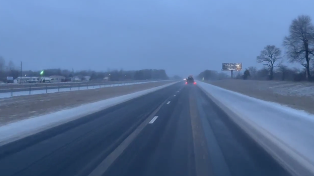
Many roads are ice-covered, making driving extremely difficult and hazardous. Motorists are encouraged to stay home if possible.
FOX Weather Correspondent Will Nunley is in Missouri where the winter storm is creating a fog over I-55 with low visibility.
FOX Weather Multimedia Journalist Hunter Davis is reporting from Tulsa, Oklahoma, where a layer of ice is covering roads and sidewalks on Thursday morning.
The chill has settled into the Southern Plains.
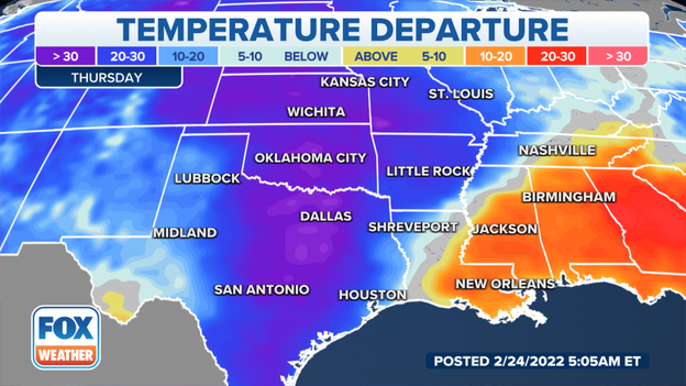
Temperatures in Texas and across the Southern Plains are between 20 and 30 degrees below average.
New video out of Brinkley, Arkansas, shows the scary moment that ice caused power lines and transformers to fall and catch fire Wednesday night.
Click here to read more about how much ice accretion is typically needed to knock out power and damage trees.
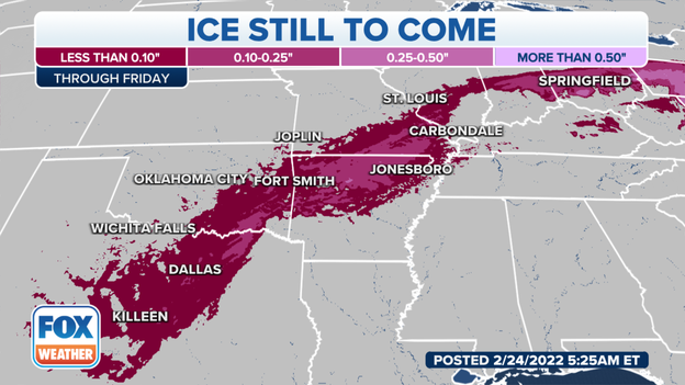
The highest ice amounts on Thursday are expected in portions of northern Arkansas and southern Missouri, where the ice could be heavy enough to knock down trees and trigger power outages.
As much as one-quarter inch of ice accretion is possible in some areas of the Ozarks.
Snow and ice from a major winter storm have triggered the cancellation of more than 1,000 flights at Dallas/Fort Worth International Airport so far Thursday morning.
FOX Weather Multimedia Journalist Hunter Davis is reporting from Tulsa, Oklahoma, Thursday morning as the state braces for another round of sleet and freezing rain from this winter storm.
Snow and ice from this next system will expand from the Southern Plains to the Midwest and Northeast through Friday.
A state trooper was responding to a crash on Interstate 35 in Oklahoma Thursday morning when another vehicle crashed into his. The officer was not in his vehicle at the time and was unharmed, according to the Oklahoma Highway Patrol.
Freezing rain has resulted in many roads becoming icy across parts of Oklahoma and Texas on Thursday morning. Officials are advising drivers to slow down and use extreme caution on the roads.
Live Coverage begins here
