Chapin, IA

Current Weather Forecast for Chapin

IA 50427 | 4:43am

Weather Conditions

10°
Feels Like -4°
Fair / Mostly Clear
Fair
27°
UV Index
0
UV Index
Air Quality
Good
Air Quality
Wind
E 10 mph
Wind
Rain
0 in
snow
Today
Wed 2/5
27°
Highest Temperature
Snow Showers
30%
Cloudy skies with a few snow showers this afternoon. High 27F. Winds ESE at 10 to 20 mph. Chance of snow 30%.
Tonight
Wed 2/5
20°
Lowest Temperature
Wintry Mix
31%
A mix of wintry precipitation this evening. Then mainly cloudy overnight. Low around 20F. S winds shifting to W at 10 to 20 mph. Chance of precip 30%.
Tomorrow
Thu 2/6
33°
Highest Temperature
Windy
5%
Sunny. Becoming windy late. High 33F. Winds WNW at 20 to 30 mph. Winds could occasionally gust over 40 mph.

Next 12 Hours Forecast in Chapin

Hourly Weather Forecast & Temperature

5AM
Partly Cloudy
11°
Feels Like -3°
Partly Cloudy
Wind
E 10 mph
Wind
Pressure
1030 mb
Pressure
Humidity
66%
Humidity
UV Index
0
UV Index
Visibility
10mi
Visibility
Visibility
44%
Cloud Cover
6AM
Partly Cloudy
11°
Feels Like -2°
Partly Cloudy
Wind
E 11 mph
Wind
Pressure
1029 mb
Pressure
Humidity
65%
Humidity
UV Index
0
UV Index
Visibility
10mi
Visibility
Visibility
52%
Cloud Cover
7AM
Cloudy
12°
Feels Like -2°
Cloudy
Wind
E 11 mph
Wind
Pressure
1028 mb
Pressure
Humidity
64%
Humidity
UV Index
0
UV Index
Visibility
10mi
Visibility
Visibility
80%
Cloud Cover
8AM
Cloudy
14°
Feels Like
Cloudy
Wind
E 10 mph
Wind
Pressure
1028 mb
Pressure
Humidity
58%
Humidity
UV Index
0
UV Index
Visibility
10mi
Visibility
Visibility
97%
Cloud Cover
9AM
Cloudy
15%
17°
Feels Like
Cloudy
Wind
ESE 12 mph
Wind
Pressure
1027 mb
Pressure
Humidity
56%
Humidity
UV Index
0
UV Index
Visibility
10mi
Visibility
Visibility
99%
Cloud Cover
10AM
Cloudy
15%
19°
Feels Like
Cloudy
Wind
ESE 13 mph
Wind
Pressure
1026 mb
Pressure
Humidity
57%
Humidity
UV Index
0
UV Index
Visibility
10mi
Visibility
Visibility
98%
Cloud Cover
11AM
Cloudy
15%
21°
Feels Like
Cloudy
Wind
ESE 15 mph
Wind
Pressure
1024 mb
Pressure
Humidity
59%
Humidity
UV Index
1
UV Index
Visibility
10mi
Visibility
Visibility
95%
Cloud Cover
12PM
Cloudy
15%
23°
Feels Like 10°
Cloudy
Wind
SE 15 mph
Wind
Pressure
1023 mb
Pressure
Humidity
60%
Humidity
UV Index
1
UV Index
Visibility
10mi
Visibility
Visibility
91%
Cloud Cover
1PM
Cloudy
15%
24°
Feels Like 12°
Cloudy
Wind
SE 14 mph
Wind
Pressure
1021 mb
Pressure
Humidity
62%
Humidity
UV Index
1
UV Index
Visibility
10mi
Visibility
Visibility
94%
Cloud Cover
2PM
Cloudy
15%
26°
Feels Like 14°
Cloudy
Wind
SE 14 mph
Wind
Pressure
1019 mb
Pressure
Humidity
64%
Humidity
UV Index
1
UV Index
Visibility
10mi
Visibility
Visibility
92%
Cloud Cover
3PM
Cloudy
18%
26°
Feels Like 15°
Cloudy
Wind
SE 13 mph
Wind
Pressure
1018 mb
Pressure
Humidity
70%
Humidity
UV Index
0
UV Index
Visibility
10mi
Visibility
Visibility
97%
Cloud Cover
4PM
Cloudy
24%
26°
Feels Like 15°
Cloudy
Wind
SE 12 mph
Wind
Pressure
1016 mb
Pressure
Humidity
75%
Humidity
UV Index
0
UV Index
Visibility
6mi
Visibility
Visibility
99%
Cloud Cover
Wed 2/5
Wed
Snow Showers
30%
27°
Afternoon snow showers. Highs in the upper 20s and lows in the low 20s.
Feels Like
-2°
Feels Like
Wind
ESE 15 mph
Wind
Humidity
65%
Humidity
UV Index
1
UV Index
Visibility
7:22 AM
Sunrise
Visibility
5:32 PM
Sunset
Thu 2/6
Thu
Windy
5%
14°
33°
Mainly sunny and windy. Highs in the low 30s and lows in the low teens.
Feels Like
Feels Like
Wind
WNW 21 mph
Wind
Humidity
54%
Humidity
UV Index
2
UV Index
Visibility
7:21 AM
Sunrise
Visibility
5:33 PM
Sunset
Fri 2/7
Fri
Cloudy
3%
11°
28°
Mostly cloudy. Highs in the upper 20s and lows in the low 20s.
Feels Like
Feels Like
Wind
NNW 6 mph
Wind
Humidity
51%
Humidity
UV Index
1
UV Index
Visibility
7:20 AM
Sunrise
Visibility
5:34 PM
Sunset
Sat 2/8
Sat
Snow Showers
62%
11°
27°
Snow showers early. Highs in the upper 20s and lows in the mid single digits.
Feels Like
Feels Like
Wind
NNE 15 mph
Wind
Humidity
78%
Humidity
UV Index
1
UV Index
Visibility
7:19 AM
Sunrise
Visibility
5:35 PM
Sunset
Sun 2/9
Sun
Partly / Cloudy
5%
26°
Times of sun and clouds. Highs in the mid 20s and lows in the upper single digits.
Feels Like
-6°
Feels Like
Wind
WNW 9 mph
Wind
Humidity
62%
Humidity
UV Index
1
UV Index
Visibility
7:17 AM
Sunrise
Visibility
5:37 PM
Sunset
Mon 2/10
Mon
Partly / Cloudy
4%
27°
Times of sun and clouds. Highs in the upper 20s and lows in the mid single digits.
Feels Like
-2°
Feels Like
Wind
N 9 mph
Wind
Humidity
62%
Humidity
UV Index
2
UV Index
Visibility
7:16 AM
Sunrise
Visibility
5:38 PM
Sunset
Tue 2/11
Tue
Partly / Cloudy
11%
-1°
15°
Partly cloudy. Highs in the low teens and lows -6 to -2F.
Feels Like
-9°
Feels Like
Wind
N 15 mph
Wind
Humidity
70%
Humidity
UV Index
2
UV Index
Visibility
7:15 AM
Sunrise
Visibility
5:39 PM
Sunset
Wed 2/12
Wed
Partly / Cloudy
3%
-4°
12°
Partly cloudy. Highs in the low teens and lows -5 to -1F.
Feels Like
-18°
Feels Like
Wind
NNW 11 mph
Wind
Humidity
64%
Humidity
UV Index
2
UV Index
Visibility
7:13 AM
Sunrise
Visibility
5:41 PM
Sunset
Need to see beyond 12 Hours?
Find more forecast on the FREE FOX WEATHER App

Latest Stories from Iowa
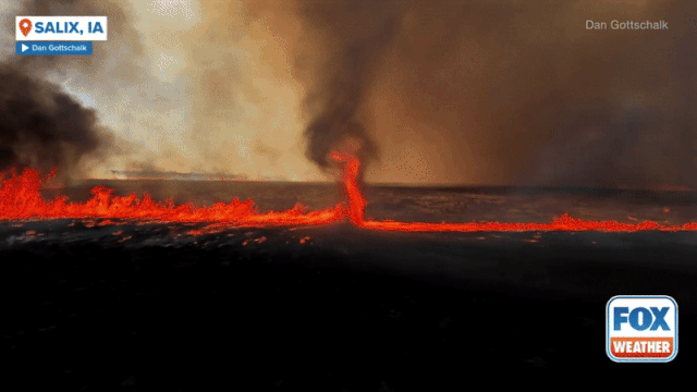
Space debris lights up night sky across Midwest

A satellite, initially identified as Starlink-5693, reentered Earth’s atmosphere Tuesday, causing a dazzling display visible from states such as Illinois, Michigan and Wisconsin. Famed astronomer Jonathan McDowell said the Starlink satellite was closely tracked by space agencies.

Loading...