Montrose, IA
See RadarCurrent Weather Forecast for Montrose
IA 52639 | 10:21pm
Weather Conditions
66°
Feels Like
66°
Fair
57°
79°
0
UV Index
Moderate
Air Quality
SE
6 mph
Wind
0
in
rain
Tonight
Wed 4/23
53°
Lowest Temperature
24%
Partly cloudy skies. Low 53F. Winds SE at 5 to 10 mph.
Tomorrow
Thu 4/24
83°
Highest Temperature
5%
Partly cloudy. High 83F. Winds SSE at 5 to 10 mph.
Tomorrow night
Thu 4/24
60°
Lowest Temperature
32%
Partly cloudy skies early giving way to a few showers after midnight. Low near 60F. Winds SSE at 5 to 10 mph. Chance of rain 30%.
Local Weather Radar - Montrose, IA
Live Montrose Local Radar Forecast by FOX Weather
Next 12 Hours Forecast in Montrose
Hourly Weather Forecast & Temperature
11PM
4%
65°
Feels Like
65°
Partly Cloudy
SE 6
mph
Wind
1018 mb
Pressure
54%
Humidity
0
UV Index
10mi
Visibility
34%
Cloud Cover
12AM
16%
63°
Feels Like
63°
1AM
2%
61°
Feels Like
61°
2AM
2%
59°
Feels Like
58°
3AM
2%
57°
Feels Like
57°
4AM
2%
56°
Feels Like
56°
5AM
3%
55°
Feels Like
55°
6AM
6%
54°
Feels Like
54°
7AM
6%
55°
Feels Like
54°
8AM
3%
59°
Feels Like
59°
9AM
2%
64°
Feels Like
64°
10AM
1%
68°
Feels Like
68°
Need to see beyond 12 Hours?
Find more forecast on the FREE FOX WEATHER App
Latest Stories from Iowa
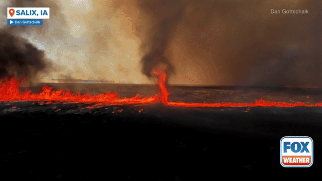
See it: Fire whirl spins through burning Iowa field sparked by severe storm's lightning
A fire whirl, otherwise known as a ‘firenado’ was caught on camera in Iowa after severe weather on Thursday night.

Severe storms target Midwest, Plains over Easter weekend
Severe weather unleashed its fury across the central Plains on Thursday evening. Several storm chasers, including FOX Weather Storm Tracker Brandon Copic, captured video of a tornado forming and then rolling across the fields of Missouri Valley, Iowa.
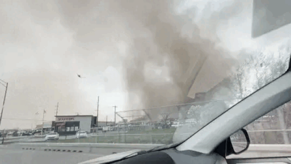
Terrifying dust storm engulfs car in York, Nebraska: 'Oh my God, I'm in a tornado'
A harrowing scene unfolded across eastern Nebraska on Thursday as storms marched across the Plains.

Large tornado spotted in Iowa as severe storms blast Plains on Thursday
The first round of severe storms pushed through the Plains on Thursday, during what is expected to be an active weekend of severe weather.