Newhall, IA

See Radar

Current Weather Forecast for Newhall

IA 52315 | 1:56am

Weather Conditions

46°
Feels Like 43°
Partly Cloudy
Partly Cloudy
41° 62°
UV Index
0
UV Index
Air Quality
Moderate
Air Quality
Wind
E 5 mph
Wind
Rain
0 in
rain

Tonight

Mon 4/21
45°
Lowest Temperature
Showers
75%
Showers and thundershowers likely. Low near 45F. Winds SSE at 10 to 15 mph. Chance of rain 80%.

Tomorrow

Tue 4/22
74°
Highest Temperature
Partly / Cloudy
15%
Intervals of clouds and sunshine. A stray afternoon thunderstorm is possible. High 74F. Winds SW at 10 to 15 mph.

Tomorrow night

Tue 4/22
53°
Lowest Temperature
Rain
69%
Partly cloudy in the evening then becoming cloudy with periods of rain after midnight. Low 53F. Winds light and variable. Chance of rain 70%. Rainfall around a half an inch.

Local Weather Radar - Newhall, IA

Live Newhall Local Radar Forecast by FOX Weather

Precipitation For Newhall rain
Intermittent rain for the next hour.

Next 12 Hours Forecast in Newhall

Hourly Weather Forecast & Temperature

2AM
Rain
90%
46°
Feels Like 44°
Rain
Wind
SE 5 mph
Wind
Pressure
1017 mb
Pressure
Humidity
89%
Humidity
UV Index
0
UV Index
Visibility
5mi
Visibility
Visibility
100%
Cloud Cover
3AM
Rain
78%
46°
Feels Like 43°
Rain
Wind
SE 8 mph
Wind
Pressure
1016 mb
Pressure
Humidity
90%
Humidity
UV Index
0
UV Index
Visibility
5mi
Visibility
Visibility
100%
Cloud Cover
4AM
Scattered Thunderstorms
51%
47°
Feels Like 42°
Scattered Thunderstorms
Wind
SE 9 mph
Wind
Pressure
1015 mb
Pressure
Humidity
90%
Humidity
UV Index
0
UV Index
Visibility
7mi
Visibility
Visibility
97%
Cloud Cover
5AM
Thunderstorms
70%
48°
Feels Like 44°
Thunderstorms
Wind
SSE 10 mph
Wind
Pressure
1015 mb
Pressure
Humidity
89%
Humidity
UV Index
0
UV Index
Visibility
6mi
Visibility
Visibility
90%
Cloud Cover
6AM
Scattered Thunderstorms
30%
49°
Feels Like 45°
Isolated Thunderstorms
Wind
SSE 12 mph
Wind
Pressure
1015 mb
Pressure
Humidity
90%
Humidity
UV Index
0
UV Index
Visibility
8mi
Visibility
Visibility
89%
Cloud Cover
7AM
Partly / Cloudy
5%
50°
Feels Like 45°
Partly Cloudy
Wind
SSE 12 mph
Wind
Pressure
1015 mb
Pressure
Humidity
91%
Humidity
UV Index
0
UV Index
Visibility
10mi
Visibility
Visibility
59%
Cloud Cover
8AM
Partly / Cloudy
3%
52°
Feels Like 48°
Partly Cloudy
Wind
S 12 mph
Wind
Pressure
1015 mb
Pressure
Humidity
89%
Humidity
UV Index
1
UV Index
Visibility
10mi
Visibility
Visibility
45%
Cloud Cover
9AM
Mostly Cloudy
6%
56°
Feels Like 52°
Mostly Cloudy
Wind
S 12 mph
Wind
Pressure
1015 mb
Pressure
Humidity
84%
Humidity
UV Index
1
UV Index
Visibility
10mi
Visibility
Visibility
61%
Cloud Cover
10AM
Partly / Cloudy
5%
60°
Feels Like 58°
Partly Cloudy
Wind
SSW 12 mph
Wind
Pressure
1015 mb
Pressure
Humidity
77%
Humidity
UV Index
3
UV Index
Visibility
10mi
Visibility
Visibility
57%
Cloud Cover
11AM
Partly / Cloudy
3%
64°
Feels Like 63°
Partly Cloudy
Wind
SW 11 mph
Wind
Pressure
1014 mb
Pressure
Humidity
72%
Humidity
UV Index
5
UV Index
Visibility
10mi
Visibility
Visibility
48%
Cloud Cover
12PM
Partly / Cloudy
15%
67°
Feels Like 67°
Partly Cloudy
Wind
WSW 11 mph
Wind
Pressure
1014 mb
Pressure
Humidity
66%
Humidity
UV Index
6
UV Index
Visibility
10mi
Visibility
Visibility
58%
Cloud Cover
1PM
Partly / Cloudy
15%
70°
Feels Like 70°
Partly Cloudy
Wind
WSW 10 mph
Wind
Pressure
1014 mb
Pressure
Humidity
59%
Humidity
UV Index
7
UV Index
Visibility
10mi
Visibility
Visibility
42%
Cloud Cover
Mon 4/21
Mon
Showers
75%
41°
62°
Showers, maybe a rumble of thunder. Lows overnight in the mid 40s.
Feels Like
43°
Feels Like
Wind
SSE 12 mph
Wind
Humidity
89%
Humidity
UV Index
0
UV Index
Visibility
6:17 AM
Sunrise
Visibility
7:56 PM
Sunset
Tue 4/22
Tue
Partly / Cloudy
15%
45°
73°
Times of sun and clouds. Highs in the mid 70s and lows in the low 50s.
Feels Like
74°
Feels Like
Wind
SW 12 mph
Wind
Humidity
66%
Humidity
UV Index
7
UV Index
Visibility
6:16 AM
Sunrise
Visibility
7:57 PM
Sunset
Wed 4/23
Wed
Scattered Thunderstorms
53%
53°
76°
Scattered thunderstorms. Highs in the mid 70s and lows in the mid 50s.
Feels Like
76°
Feels Like
Wind
SSE 10 mph
Wind
Humidity
70%
Humidity
UV Index
4
UV Index
Visibility
6:14 AM
Sunrise
Visibility
7:58 PM
Sunset
Thu 4/24
Thu
Scattered Showers
31%
54°
77°
Showers possible in the afternoon. Highs in the upper 70s and lows in the mid 50s.
Feels Like
77°
Feels Like
Wind
ESE 9 mph
Wind
Humidity
63%
Humidity
UV Index
4
UV Index
Visibility
6:13 AM
Sunrise
Visibility
7:59 PM
Sunset
Fri 4/25
Fri
Showers
50%
52°
65°
Showers possible. Highs in the mid 60s and lows in the upper 40s.
Feels Like
65°
Feels Like
Wind
NNE 15 mph
Wind
Humidity
82%
Humidity
UV Index
3
UV Index
Visibility
6:11 AM
Sunrise
Visibility
8:00 PM
Sunset
Sat 4/26
Sat
Partly / Cloudy
6%
47°
65°
Mix of sun and clouds. Highs in the mid 60s and lows in the low 50s.
Feels Like
65°
Feels Like
Wind
E 13 mph
Wind
Humidity
67%
Humidity
UV Index
6
UV Index
Visibility
6:10 AM
Sunrise
Visibility
8:01 PM
Sunset
Sun 4/27
Sun
Mostly Cloudy
24%
50°
69°
Mostly cloudy. Highs in the upper 60s and lows in the upper 50s.
Feels Like
69°
Feels Like
Wind
SE 15 mph
Wind
Humidity
68%
Humidity
UV Index
6
UV Index
Visibility
6:08 AM
Sunrise
Visibility
8:02 PM
Sunset
Mon 4/28
Mon
Isolated Thunderstorms
31%
59°
82°
Partly cloudy, chance of a thunderstorm. Highs in the low 80s and lows in the mid 60s.
Feels Like
83°
Feels Like
Wind
SSE 17 mph
Wind
Humidity
71%
Humidity
UV Index
6
UV Index
Visibility
6:07 AM
Sunrise
Visibility
8:03 PM
Sunset
Need to see beyond 12 Hours?
Find more forecast on the FREE FOX WEATHER App

Latest Stories from Iowa
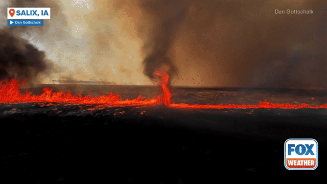
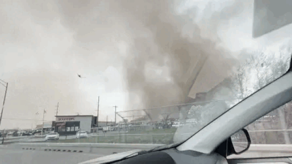
Severe storms target Midwest, Plains over Easter weekend

Severe weather unleashed its fury across the central Plains on Thursday evening. Several storm chasers, including FOX Weather Storm Tracker Brandon Copic, captured video of a tornado forming and then rolling across the fields of Missouri Valley, Iowa.