Norwalk, IA
See RadarCurrent Weather Forecast for Norwalk
IA 50982 | 6:18pm
Weather Conditions
Tonight
Tomorrow
Tomorrow night
Local Weather Radar - Norwalk, IA
Live Norwalk Local Radar Forecast by FOX Weather
Next 12 Hours Forecast in Norwalk
Hourly Weather Forecast & Temperature
Latest Stories from Iowa

Millions under growing threat of potential tornado outbreak from southern Plains to Upper Midwest Monday
The daunting forecast comes as a potent spring storm collects all the ingredients needed for a volatile atmosphere, leading to an intense severe weather outlook that hasn't been seen in some regions in 14 years.

Weekend Weather Update from FOX Weather: Potential tornado outbreak threat grows for final week of April
Top weather news for April 26, 2025: The danger of a widespread tornado outbreak is growing for Monday across the Upper Midwest and into the Southern Plains with threats of strong tornadoes, large hail and damaging wind gusts.
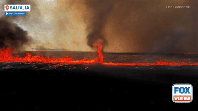
See it: Fire whirl spins through burning Iowa field sparked by severe storm's lightning
A fire whirl, otherwise known as a ‘firenado’ was caught on camera in Iowa after severe weather on Thursday night.

Severe storms target Midwest, Plains over Easter weekend
Severe weather unleashed its fury across the central Plains on Thursday evening. Several storm chasers, including FOX Weather Storm Tracker Brandon Copic, captured video of a tornado forming and then rolling across the fields of Missouri Valley, Iowa.