Hay Springs, NE

See Radar

Current Weather Forecast for Hay Springs

NE 69347 | 12:24am

Weather Conditions

36°
Feels Like 30°
Cloudy
Cloudy
41° 46°
UV Index
0
UV Index
Air Quality
Good
Air Quality
Wind
NNE 8 mph
Wind
Rain
0.01 in
rain

Tonight

Thu 4/24
33°
Lowest Temperature
Foggy
24%
Low clouds and fog. Slight chance of a rain shower. Low 33F. Winds NNE at 5 to 10 mph.

Tomorrow

Fri 4/25
44°
Highest Temperature
Rain / Snow
38%
Cloudy with rain and snow showers in the morning. Remaining cloudy in the afternoon. High 44F. Winds ENE at 10 to 15 mph. Chance of rain 40%.

Tomorrow night

Fri 4/25
38°
Lowest Temperature
Cloudy
24%
Cloudy. Low 38F. Winds SE at 10 to 20 mph.

Local Weather Radar - Hay Springs, NE

Live Hay Springs Local Radar Forecast by FOX Weather

Next 12 Hours Forecast in Hay Springs

Hourly Weather Forecast & Temperature

1AM
Cloudy
24%
36°
Feels Like 31°
Cloudy
Wind
NNE 7 mph
Wind
Pressure
1025 mb
Pressure
Humidity
97%
Humidity
UV Index
0
UV Index
Visibility
5mi
Visibility
Visibility
100%
Cloud Cover
2AM
Cloudy
15%
36°
Feels Like 30°
Cloudy
Wind
NNE 7 mph
Wind
Pressure
1025 mb
Pressure
Humidity
97%
Humidity
UV Index
0
UV Index
Visibility
5mi
Visibility
Visibility
100%
Cloud Cover
3AM
Cloudy
15%
35°
Feels Like 31°
Cloudy
Wind
NNE 6 mph
Wind
Pressure
1026 mb
Pressure
Humidity
98%
Humidity
UV Index
0
UV Index
Visibility
5mi
Visibility
Visibility
100%
Cloud Cover
4AM
Rain / Snow
38%
35°
Feels Like 30°
Rain/Snow Showers
Wind
NNE 5 mph
Wind
Pressure
1026 mb
Pressure
Humidity
100%
Humidity
UV Index
0
UV Index
Visibility
1.4mi
Visibility
Visibility
99%
Cloud Cover
5AM
Foggy
29%
35°
Feels Like 30°
Foggy
Wind
NNE 6 mph
Wind
Pressure
1026 mb
Pressure
Humidity
100%
Humidity
UV Index
0
UV Index
Visibility
0.5mi
Visibility
Visibility
99%
Cloud Cover
6AM
Foggy
17%
34°
Feels Like 29°
Foggy
Wind
NNE 6 mph
Wind
Pressure
1027 mb
Pressure
Humidity
100%
Humidity
UV Index
0
UV Index
Visibility
0.31mi
Visibility
Visibility
99%
Cloud Cover
7AM
Foggy
24%
34°
Feels Like 28°
Foggy
Wind
NE 6 mph
Wind
Pressure
1028 mb
Pressure
Humidity
100%
Humidity
UV Index
0
UV Index
Visibility
0.31mi
Visibility
Visibility
99%
Cloud Cover
8AM
Rain / Snow
39%
36°
Feels Like 30°
Rain/Snow Showers
Wind
NE 7 mph
Wind
Pressure
1028 mb
Pressure
Humidity
100%
Humidity
UV Index
0
UV Index
Visibility
0.5mi
Visibility
Visibility
99%
Cloud Cover
9AM
Rain / Snow
35%
38°
Feels Like 32°
Rain/Snow Showers
Wind
NE 8 mph
Wind
Pressure
1028 mb
Pressure
Humidity
93%
Humidity
UV Index
1
UV Index
Visibility
0.78mi
Visibility
Visibility
100%
Cloud Cover
10AM
Showers
35%
40°
Feels Like 33°
Showers
Wind
NE 9 mph
Wind
Pressure
1028 mb
Pressure
Humidity
88%
Humidity
UV Index
2
UV Index
Visibility
0.79mi
Visibility
Visibility
100%
Cloud Cover
11AM
Showers
32%
41°
Feels Like 35°
Few Showers
Wind
ENE 9 mph
Wind
Pressure
1028 mb
Pressure
Humidity
83%
Humidity
UV Index
2
UV Index
Visibility
1.4mi
Visibility
Visibility
100%
Cloud Cover
12PM
Showers
34%
41°
Feels Like 36°
Few Showers
Wind
ENE 9 mph
Wind
Pressure
1028 mb
Pressure
Humidity
82%
Humidity
UV Index
3
UV Index
Visibility
4mi
Visibility
Visibility
100%
Cloud Cover
Thu 4/24
Thu
Foggy
24%
41°
46°
Dense fog in some areas. Lows overnight in the low 30s.
Feels Like
29°
Feels Like
Wind
NNE 9 mph
Wind
Humidity
98%
Humidity
UV Index
0
UV Index
Visibility
5:54 AM
Sunrise
Visibility
7:43 PM
Sunset
Fri 4/25
Fri
Rain / Snow
38%
35°
43°
Rain and snow showers in the morning. Highs in the mid 40s and lows in the upper 30s.
Feels Like
28°
Feels Like
Wind
ENE 11 mph
Wind
Humidity
85%
Humidity
UV Index
3
UV Index
Visibility
5:53 AM
Sunrise
Visibility
7:45 PM
Sunset
Sat 4/26
Sat
Windy
20%
33°
44°
Windy with clouds. Highs in the upper 50s and lows in the upper 40s.
Feels Like
31°
Feels Like
Wind
SSE 25 mph
Wind
Humidity
77%
Humidity
UV Index
3
UV Index
Visibility
5:51 AM
Sunrise
Visibility
7:46 PM
Sunset
Sun 4/27
Sun
Partly / Cloudy
24%
39°
57°
Morning clouds followed by afternoon sun. Highs in the mid 70s and lows in the mid 40s.
Feels Like
74°
Feels Like
Wind
S 17 mph
Wind
Humidity
62%
Humidity
UV Index
7
UV Index
Visibility
5:50 AM
Sunrise
Visibility
7:47 PM
Sunset
Mon 4/28
Mon
Showers
66%
48°
74°
Windy with showers at times. Highs in the upper 50s and lows in the mid 30s.
Feels Like
41°
Feels Like
Wind
WNW 23 mph
Wind
Humidity
59%
Humidity
UV Index
6
UV Index
Visibility
5:49 AM
Sunrise
Visibility
7:48 PM
Sunset
Tue 4/29
Tue
Partly / Cloudy
6%
37°
59°
Mix of sun and clouds. Highs in the low 60s and lows in the low 40s.
Feels Like
32°
Feels Like
Wind
W 11 mph
Wind
Humidity
55%
Humidity
UV Index
7
UV Index
Visibility
5:47 AM
Sunrise
Visibility
7:49 PM
Sunset
Wed 4/30
Wed
Partly / Cloudy
24%
34°
63°
Times of sun and clouds. Highs in the mid 60s and lows in the upper 30s.
Feels Like
66°
Feels Like
Wind
WNW 15 mph
Wind
Humidity
52%
Humidity
UV Index
6
UV Index
Visibility
5:46 AM
Sunrise
Visibility
7:50 PM
Sunset
Thu 5/1
Thu
Partly / Cloudy
11%
40°
66°
Partly cloudy. Highs in the low 60s and lows in the mid 30s.
Feels Like
35°
Feels Like
Wind
NNW 13 mph
Wind
Humidity
53%
Humidity
UV Index
7
UV Index
Visibility
5:45 AM
Sunrise
Visibility
7:51 PM
Sunset
Need to see beyond 12 Hours?
Find more forecast on the FREE FOX WEATHER App

Latest Stories from Nebraska
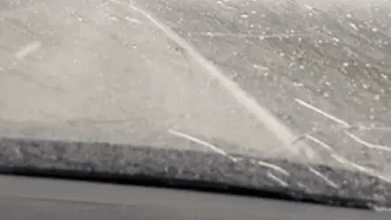
Severe storms target Midwest, Plains over Easter weekend

Severe weather unleashed its fury across the central Plains on Thursday evening. Several storm chasers, including FOX Weather Storm Tracker Brandon Copic, captured video of a tornado forming and then rolling across the fields of Missouri Valley, Iowa.

Loading...