Hurricane forecasters expect below-normal cyclone activity through September's season peak
The period of tropical activity from Aug. 12 through Sept. 3 has marked the quietest period in tropical weather development in 56 years. CSU said through Sept. 16, the basin favors either below or near-normal activity with only a 10% chance of above-normal formation.

What is causing the quiet period during the 2024 Atlantic hurricane season?
Colorado State University Hurricane Specialist Phil Klotzbach and FOX Weather Hurricane Specialist Bryan Norcross discuss the ongoing quieter period for the 2024 Atlantic hurricane season. Hostile factors in the eastern Atlantic, including cooler waters near the coast of Africa, are helping suppress storm activity.
Hurricane researchers at Colorado State University are working to temper expectations for a potentially record-breaking year but are not willing to wave the white flag yet and signal a premature end to the season.
On Tuesday, Dr. Phil Klotzbach, a hurricane specialist at CSU, said he expects tropical cyclone activity in the basin to be at normal or below-normal levels through at least Sept. 16. The chance of above-normal activity during the next few weeks is just 10% as the basin remains in a state of record inactivity.
In fact, the lack of tropical activity from Aug. 12 through Sept. 3 marked the quietest period in tropical weather development in 56 years, with the basin now starting to fall behind key metrics for an average season.
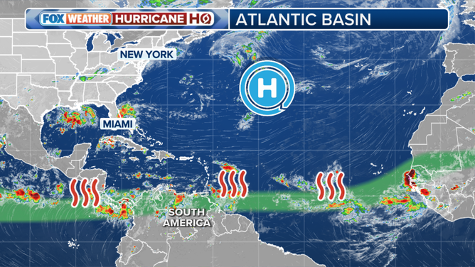
Atlantic tropical weather outlook September 3, 2024
(FOX Weather)
As of Sept. 4, an average season would have already produced seven named tropical storms, two hurricanes and one major cyclone.
So far in 2024, the basin has seen five named storms, three hurricanes and one major hurricane. However, with only limited activity expected over the next two weeks, the basin is likely to fall short of what a typical year produces.
"So, what’s been inhibiting storms the past few weeks? I think the big problem has been the position of the monsoon trough over Africa," Klotzbach told FOX Weather. "We’ve had anomalous cooling in the Gulf of Guinea region, associated with a trend towards Atlantic Nina (although we may not officially meet the definition). Because of this, we have a strong cross-equatorial (sea surface temperature) and sea level pressure gradient, helping to push the monsoon trough too far north if you’re looking for hurricane activity."
IS THERE A WEATHER PHENOMENON KNOWN AS THE ATLANTIC NINA?
What is going on with the tropics?
There are at least four different elements forecasters are highlighting that are weighing down activity: the location of the monsoon trough over Africa, cooling waters in the eastern Atlantic, significantly warm temperatures in the upper levels of the atmosphere and abundant dry air around the eastern edge of the basin.
Computer models are not keen on picking up these deviations from the norm, which likely negated favorable features such as reduced vertical wind shear, near-record sea-surface temperatures, the enhanced African monsoon and the budding La Niña status of the El Niño-Southern Oscillation.
With all that said, the most significant and only question that remains is whether favorable conditions will return to the basin or if the season is effectively over.
"I think it’s too early to bail on the season just yet," Klotzbach stated. "The latest EPS ensemble is more robust on Atlantic tropical cyclone activity coming up. As we talk about in our two-week forecast, the current National Hurricane Center area in the Caribbean bears watching once it gets into the Gulf of Mexico. In addition, a strong easterly wave looks poised to move off of Africa in about one week. It’s too early to know what will happen with that system, but overall, conditions for its intensification look pretty healthy at this point."
It is still possible that the season could reach normal levels of activity, with 14 named storms, seven hurricanes and three major hurricanes, but amounts significantly above what an average season produces appear to be out of reach.
It's important to remember that a normal season can be just as impactful as a busier-than-average year.
The 2022 season was considered to be near a normal season with 14 named storms, eight hurricanes and two majors, but saw the production of Hurricane Ian, which resulted in the year becoming the third costliest in history.
In contrast, 2023 was considered to be a busier-than-average season with 20 named storms but was the least impactful for the U.S. in a decade.
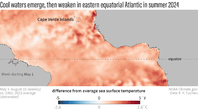
Cool waters in the eastern Atlantic Ocean
(NOAA)
SEPTEMBER TO MAKE OR BREAK ROBUST HURRICANE SEASON OUTLOOKS
Klotzbach said the 2024 Atlantic hurricane season has been a "tale of two seasons," with Hurricane Beryl becoming a Category 5 in August.
"It's been really quiet lately, but still, in terms of that asymmetric, we will still be above average till Sept. 9 because that storm put us so far ahead of schedule," he said.
Tropical activity down across much of the globe
Researchers did not mention in their latest update that activity around the world is at record-low levels despite record-warm sea-surface temperatures.
In other words, the Atlantic is not just experiencing a one-off year; basins in the Indian and Pacific oceans are similarly affected by widespread inactivity.
The overall reduction in activity is not unheard of as tropical weather experts, including Klotzbach, have long suggested that overall global tropical cyclone activity is on the decline worldwide, especially in the Western Pacific.
"By investigating global TC activity from 1990 to 2021, we find significant decreasing trends in global hurricane numbers and ACE, primarily due to a significant decreasing trend in the western North Pacific," researchers stated in the 2022 report. However, the report did state cyclones that do form are becoming costlier and more prone to rapid intensification.
It remains to be seen whether the dramatic downturn in tropical cyclone activity around the globe is a precursor of less-impactful years to come or whether it was just an anomalous year.
"Obviously, the million-dollar question is will this period continue to be quiet or will we start to ramp up as we get into the second half of the season," Klotzbach said. "There's a lot of the hurricane season left to go."
The hurricane season in the Atlantic, Eastern and Central Pacific runs through Nov. 30, but in basins such as the Western Pacific, activity can form year-round.