5 weather events to watch for in 2025
Will winter flop? Will El Nino return? Will the hurricane season be another above-average ordeal? Just a few of the questions that will likely be top of mind as the calendar flips to 2025.
The meaning of El Nino and La Nina
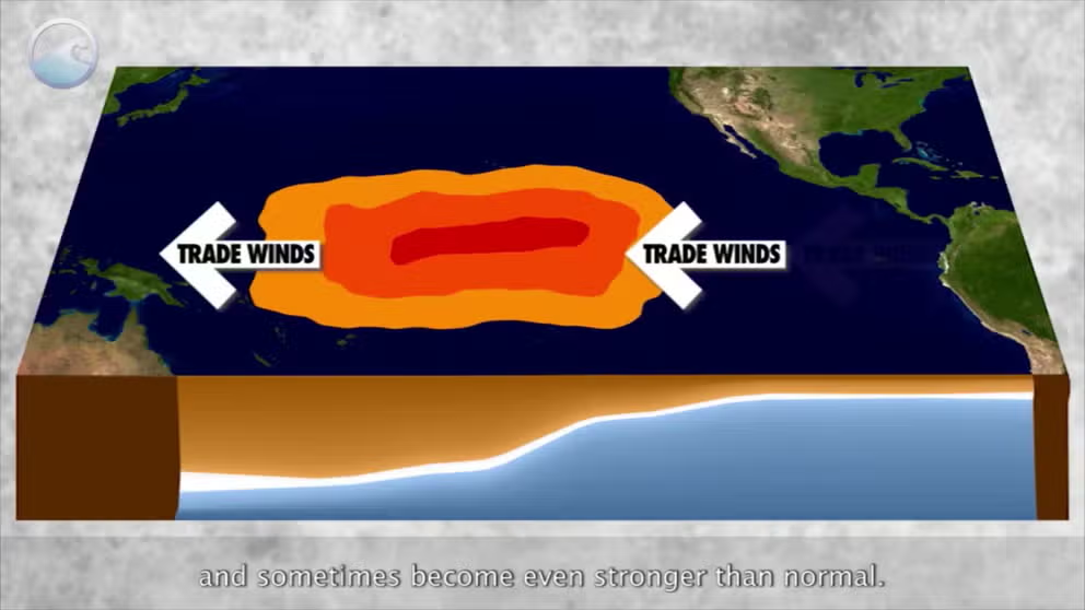
The status of whether the world is being impacted by an El Nino or a La Nina is determined by water temperatures in the central and eastern Pacific. (NOAA)
As the calendar turns to 2025, weather watchers will be keeping an eye out for droughts, flooding, severe weather, hurricanes, fires and heat waves that plague the nation every year.
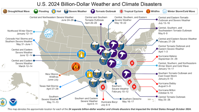
Annually, nearly 2 dozen of these events become billion-dollar disasters, with 2024 being no exception when compared to recent years.
Of the billion-dollar disasters in 2024, 17 were severe weather outbreaks, four were tropical cyclones, one was a wildfire and two were winter storm events.
According to NOAA, the disasters led to more than 400 deaths and losses that were on track to exceed $100 billion.

This NOAA NCEI map shows the approximate location of all billion-dollar disasters in the U.S. for 2024.
(NOAA)
A significant factor in understanding global climate patterns is the status of the El Niño-Southern Oscillation, commonly known as ENSO.
Ocean temperatures in the central and eastern Pacific play a key role in triggering events such as El Niño, La Niña and neutral conditions, each of which has a distinct impact on global weather.
While one phase of ENSO may bring warmer and drier conditions than usual, another can produce the opposite effect.
Here’s a preview of the weather events to watch for in 2025.
HOW THE WEATHER CAN INFLUENCE BABY NAMES
1) Will winter turn out to be another flop or a tundra?
Winter 2023-24 was the warmest on record across the country, with an average temperature of 5.4 °F above average.
Cities such as Minneapolis, Philadelphia and New York reported extensive snowfall deficits, with rainfall more common than frozen precipitation.
The season was not a fluke; it is a trend, largely attributed to climate change.
According to Climate Central, a nonprofit organization that reports on the impacts of climate change, winters from 1970 to 2024 have warmed by 4 °F on average, with shorter and less extensive cold snaps.

Warming winters
(FOX Weather)
While this winter season started off cold, with temperatures across the nation averaging around 3 degrees cooler than average through the first days of December, the tide quickly turned in mid-December, with the mercury reaching well above average.
With minimal snow cover on the ground, it is tough for Arctic outbreaks to have staying power, as the ground cover acts as a conveyor belt for cold air.
In preseason outlooks, NOAA suggested that the winter season had a higher chance of being warmer than average, which is in line with previous years.
LITTLE-KNOWN WEATHER PATTERN WHEN EL NINO AND LA NINA ARE NO LONGER IN CONTROL
2) Will the ENSO find its way back into El Niño territory?
The year 2024 began with an El Niño event over the Pacific, which transitioned into neutral conditions during the early summer.
Throughout much of the past year, climate models predicted a cooling of waters in the central and eastern Pacific. However, the transition has occurred more slowly than expected.
The reluctance of the global climate to shift into the La Niña phase of the ENSO has raised questions among climate experts about the possibility of another El Niño emerging in the new year.
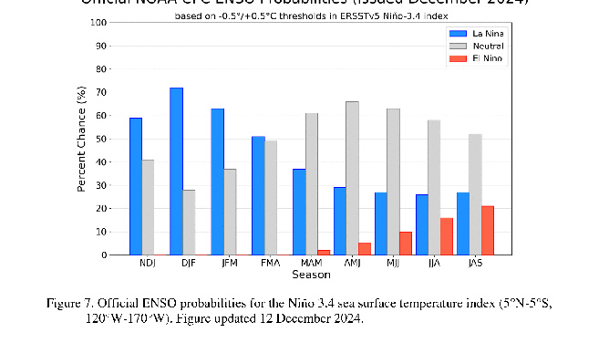
NOAA currently estimates the likelihood of entering an El Niño during the January-February-March period at just 1%, with the probability rising to 20% over the summer.
These odds have been steadily increasing, but are still far from a guarantee.
Overall, neutral conditions are expected to dominate for most of the year, which typically leads to less extreme weather patterns.

Chances of an El Nino, La Nina or neutral conditions
SEE THE SIX DAYS NATIONAL PARKS WILL HAVE FREE ADMISSION IN 2025
3) Will drought and fire conditions reemerge over the West?
Most of 2024 saw reduced fire activity along the West Coast, aided by a series of wet winters.
The region enters 2025 in a relatively strong position, with only about 35% officially experiencing drought conditions.
The amount of precipitation on the West Coast is directly tied to the status of the ENSO. El Niño events generally lead to more precipitation, while La Niña events typically result in below-average rainfall—though there are exceptions.

(FOX Weather)
Weak La Niña events tend to bring more storminess to the West Coast than stronger cycles.
Neutral ENSO conditions usually result in average winter seasons, meaning extremes of drought or flooding are unlikely.
The combination of a strong starting point and a favorable ENSO status for precipitation could lead to another low-fire-activity year, at least in the Golden State.
2024 CLOSES OUT AS WORLD’S WARMEST YEAR EVER
4) Will the hurricane season be another active cycle?
The Atlantic hurricane season will start again on June 1, 2025, and run through Nov. 30.
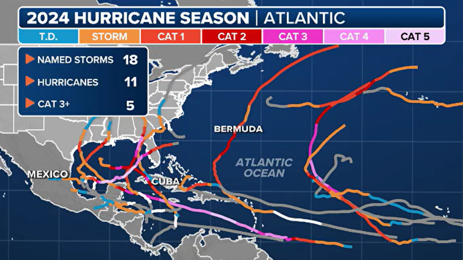
In 2024, 18 named storms formed, with 11 becoming hurricanes and five strengthening into major hurricanes.
An average season produces 14 named storms, seven hurricanes, and three major hurricanes.

2024 hurricane season summary
The last time a year experienced near-normal numbers was in 2022, but if you remove that year from the equation, the last season to see below-average activity was a decade ago, in 2015.
Simply based on previous activity numbers, the hurricane season will likely be at or above average, but it will be anyone’s guess how busy it’ll be.
Several years of neutral ENSO status have produced significant hurricane seasons, but if El Niño starts to reemerge during 2025, activity will likely be reduced. However, there is nothing in long-term climate models to suggest the basin will completely shut down.
5) Will the year be a three-peat for record-breaking global temperatures?
The world is closing out its warmest year on record, and if the phrase sounds like a broken record, it is because the record was set just last year.
Preliminary data from the Copernicus Climate Change Service shows that global temperature anomalies reached between 1.5 and 1.6 degrees Celsius (between 2.7 and 2.9 degrees Fahrenheit) above pre-industrial levels during the first 11 months of 2024, exceeding 2023’s record of 1.48 degrees Celsius (2.66 degrees Fahrenheit).
Depending on how temperature data from the final month of the year shakes out, 2024 could become the first year in recorded history to finish above the critical threshold of 1.5 degrees Celsius (2.7 degrees Fahrenheit).

Copernicus Climate Change Service yearly temperature chart
(Copernicus Climate Change Service / FOX Weather)
"With Copernicus data in from the penultimate month of the year, we can now confirm with virtual certainty that 2024 will be the warmest year on record and the first calendar year above 1.5°C," Samantha Burgess, deputy director of the Copernicus Climate Change Service, said in a statement. "This does not mean that the Paris Agreement has been breached, but it does mean ambitious climate action is more urgent than ever."
Some scientists predict that 2025 will be slightly cooler compared to previous years due to a shift from a strong El Niño to a La Niña pattern in the coming months, but the new year is still expected to remain above climatic norms.
