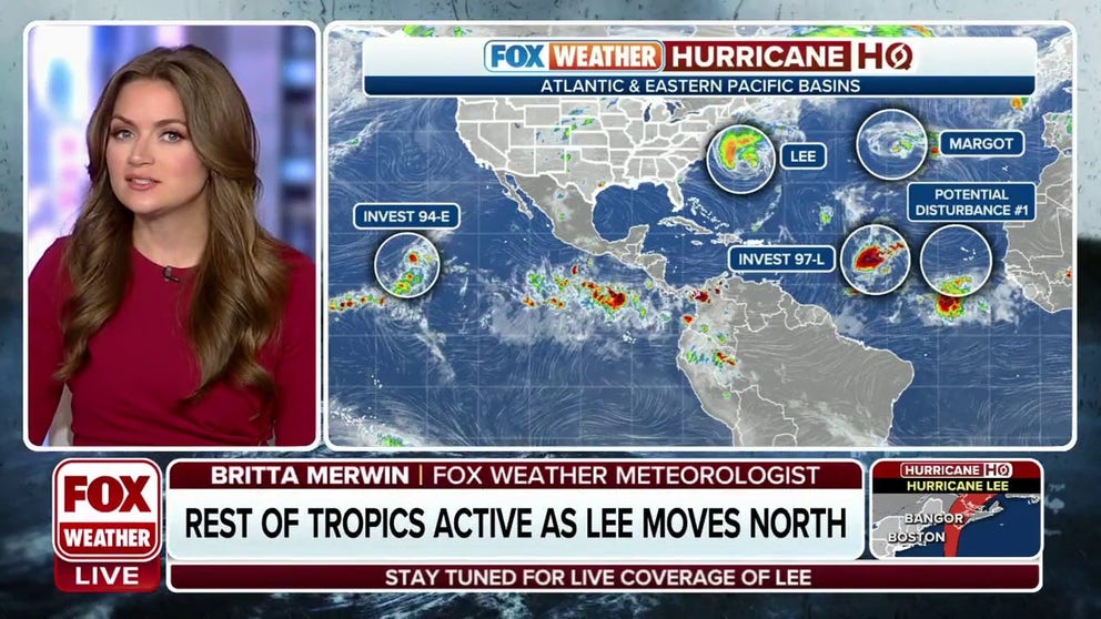
As Hurricane Lee threatens land, Margot continues to meander and eyes are on a new tropical disturbance
The National Hurricane Center continues to track hurricanes Lee and Margot, Invest 97L and a new tropical disturbance off Africa in the Atlantic Basin. One of the latter two could become Nigel, the next named storm of the season.
Newly designated areas to monitor for potential tropical development in Atlantic Ocean basin
In addition to Hurricane Lee and Tropical Storm Margot, what will likely become Tropical Storm Nigel is swirling off the coast of Africa and a new tropical disturbance is being monitored by the NHC.
As of Friday at 11:00 AM, Invest 97L has developed into Tropical Depression Fifteen. Continuous coverage of Tropical Depression Fifteen and the overall Atlantic has moved here.
With 14 named storms, the 2023 Atlantic hurricane season has already met and is close to surpassing last season's named storms, with the 15th-named storm looming on the horizon. Three systems, including Hurricane Lee, continue to swirl in the active Atlantic Ocean.
Sunday marked hurricane season's climatological peak, with the season still ongoing until the end of November. Here's a look at the current tropical activity in the Atlantic and Pacific basins as of Friday:

(FOX Weather)
Hurricane Lee causing rough seas, rip currents
Tropical Storm Warnings and Hurricane Watches are in effect as dangerous surf and rip current conditions from Hurricane Lee are affecting much of the East Coast.
This comes as Category 1 Hurricane Lee's expansive wind and wave field progresses northward over the western Atlantic. On the forecast track, the center of Lee will approach the coast of New England and Atlantic Canada on Friday and Saturday, and move across Atlantic Canada on Saturday night and Sunday, the NHC said.
Maximum sustained winds are near 85 mph with higher gusts. Slow weakening is forecast during the next few days; however, Lee is likely to remain a large and dangerous storm into the weekend, the NHC said.
WHAT TO EXPECT IN SEPTEMBER DURING HURRICANE SEASON

(FOX Weather)
Tropical Storm Margot no threat to land
What was Hurricane Margot has weakened to a tropical storm Friday morning. The storm is still not expected to threaten the U.S.
Margot is about 645 miles west of the Azores island chain and has 70-mph winds. The storm is essentially adrift and is forecast to still meander within weak steering currents Friday before making a small clockwise loop over the weekend while it further drops in strength to about 50 mph.
Swells generated by Margot will continue to affect the Azores for the next several days, the NHC said. These swells are likely to cause life-threatening surf and rip current conditions.

(FOX Weather)
Tracking Invest 97L – future Tropical Storm Nigel?
The National Hurricane Center is also tracking Invest 97L located halfway between the Lesser Antilles and the Cabo Verde Islands, as showers and thunderstorms within the invest are showing some signs of organization. Invest 98L was also in this area earlier this week but has since merged with 97L to become one system.
An "invest" is a designation given by the National Hurricane Center for tropical disturbances that warrant additional monitoring. Conditions appear more favorable for development as it moves further into the eastern tropical Atlantic.
A tropical depression is likely to form within the next day or so while the low moves west-northwestward to northwestward at 10-15 mph across the central tropical Atlantic, the NHC said.
The formation chance through the next two days is 90%. If this system becomes the next named storm of the season, it would be Nigel.
STRONGEST ATLANTIC HURRICANES IN HISTORY

(FOX Weather)
New tropical disturbance forms off Africa
A new tropical wave is forecast to emerge off the west coast of Africa by the middle part of next week, according to the NHC. It's still several days away from relevance, but some gradual development of this system is possible once it moves off Africa and begins its westward jaunt across the eastern tropical Atlantic.

(FOX Weather)
Right now, the NHC only gives the system a 20% of developing by the end of next week.
