Bryan Norcross: Atlantic disturbance Invest 94L to track near the Caribbean Islands tomorrow
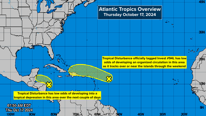
The National Hurricane Center is now giving the disturbance a low chance of organizing enough to be designated a tropical depression between now and early next week.

FOX Weather is your Hurricane HQ.
(FOX Weather)
The compact tropical disturbance we've been following across the Atlantic will move near or just north of the northeastern Caribbean islands tomorrow. The consensus of the computer forecast models is that the system won't intensify significantly but will bring heavy rain and potential flooding to the mountainous islands as it zips past over the next few days.
The National Hurricane Center is now giving the disturbance a low chance of organizing enough to be designated a tropical depression between now and early next week. It could briefly develop into Tropical Storm Nadine, but the odds of that happening now appear very low.
A number of reliable computer forecast models weaken or dissipate the system so that it only causes a minor moisture surge passing over the islands. In any case, about Sunday, the disturbance, whatever form it's in, will run into a cold front and hostile winds that should kill it off or merge it with the front. In any case, it should be off the board by early next week.
This system is no threat to Florida or the Southeast U.S.
In the Caribbean, the broad disturbance near the border of Nicaragua and Honduras has a slight chance of developing into a tropical depression before it moves inland. The National Hurricane Center has the odds of development in the low category.

Disturbances over Atlantic
(National Hurricane Center)
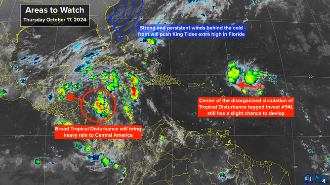
The biggest threat from the system looks likely to be heavy rain and possible mudslides over the mountains of Central America.
On the east coast of Florida. strong and persistent northeasterly winds behind the cold front – the same one that is going to block the Atlantic disturbance's progress – will aggravate the King Tides beginning today. Water levels will be about a foot and a half to 2 feet above the normal high tide due to the combination of a close-to-earth full moon and the winds pushing the ocean water against the coast.

Satellite images of disturbances in the Atlantic
(NOAA)
Remember, tidal flooding is saltwater, which can damage your car. Also, you'll see flooding in areas that are not next to the water because the seawater will be pushed up through the sewers. Avoid puddles if it hasn't been raining. No significant rain is predicted along most of the Florida coast.
This cycle of high tides will peak over the weekend into early next week.