Why Atlantic hurricane season could turn active again in early August
The FOX Forecast Center believes the hostile weather patterns currently in place across the tropical Atlantic will fade away as the calendar flips to a new month. Computer forecast models are suggesting a recurring climate cycle called the Madden-Julian Oscillation (MJO) will create more favorable atmospheric conditions for tropical storm and hurricane development in the Atlantic during the first half of August.

Atlantic hurricane season poised to roar back to life in early August
The tropics overall remain in a lull, with no development expected in the Atlantic through the end of July. However, this lull is not expected to last. The Saharan dust and large-scale sinking air, which have shut off the Atlantic in recent weeks, are expected to fade away, and when that happens, the expectation is that the Atlantic Basin will quickly awaken again.
An outbreak of Saharan dust has kept tropical activity in the Atlantic Basin at bay since Hurricane Beryl lashed Texas more than two weeks ago, but the current lull might not last much longer due to an expected change in weather patterns across the tropics beginning in early August.
Over the past month, multiple plumes of dust from the Sahara Desert in Africa have traversed the tropical Atlantic. According to NOAA, the air surrounding a Saharan Air Layer (SAL) has about 50% less moisture than the typical atmosphere, which means the presence of the SAL can be detrimental to cloud formation and thunderstorm activity, which are building blocks for tropical cyclones.
(FOX Weather)
Significant plumes of dust and dry air are common in the Atlantic during the first two and a half months of the hurricane season and help to limit tropical cyclone formation.
Tropical Storm Alberto, Hurricane Beryl and Tropical Storm Chris, which all developed during a busy stretch between mid-June and early July, were each able to find favorable spots for development outside the Saharan dust plumes. Ever since that parade of named storms, the dust has put a lid on the tropics.
The National Hurricane Center (NHC) doesn't expect any tropical storms or hurricanes to form in the Atlantic for at least the next week. In fact, the only active tropical cyclone in the world on Tuesday was Typhoon Gaemi in the Western Pacific Ocean, which is forecast to become a Category 4-equivalent storm as it barrels toward Taiwan by midweek, according to the U.S. Joint Typhoon Warning Center.
5 DIFFERENT NAMES FOR HURRICANES AROUND THE WORLD

(FOX Weather)
Tropical uptick possible in early August
The FOX Forecast Center believes the hostile weather patterns currently in place across the tropical Atlantic will fade away as the calendar flips to a new month.
Computer models run by NOAA's Climate Prediction Center are suggesting a recurring climate cycle called the Madden-Julian Oscillation (MJO) will create more favorable atmospheric conditions for tropical storm and hurricane development in the Atlantic during the first half of August.
The MJO is an eastward-traveling pulse of waves of enhanced moisture and dry air that impact areas along the equator and the subtropics. It is estimated that any one particular point within the MJO takes 30-60 days to circle the Earth.
WHAT ARE THE ARCTIC OSCILLATION, NORTH AMERICAN OSCILLATION AND MADDEN-JULIAN OSCILLATION?
During the summer and fall, the MJO can lead to an increase in hurricane activity in regions considered to be in enhanced precipitation zones (rising air) and a decrease in tropical cyclone activity in suppressed regions (sinking air).
Computer forecast models indicate this enhanced precipitation zone with rising air, associated with the MJO, will move over the tropical Atlantic Ocean in early August.
While there are no guarantees, this pattern would at least make conditions more conducive for tropical development than they have been in recent weeks.
(FOX Weather)
Busiest time of hurricane season lies ahead
Research shows that it's not unusual for the Atlantic Basin to enter a quiet period in late July.
However, the busiest time of hurricane season still looms in August and September. That coincides with the warmest ocean temperatures, lowest wind shear – the change in wind speed and direction with height – and fewer outbreaks of Saharan dust.
"On average, tropical development doesn't accelerate until about the second week of August," FOX Weather Hurricane Specialist Bryan Norcross said. "The peak date, when there is most likely to be a named storm somewhere in the Atlantic, is about Sept. 10. But notice the likelihood of storm development ramps up very quickly in the few weeks before that date and slowly tails off through the rest of September and October."
BRYAN NORCROSS: THE TROPICS ARE QUIET, BUT DON'T FORGET 1969
In fact, more than 90% of activity during the hurricane season typically occurs between August and the end of the season, according to an index called Accumulated Cyclone Energy (ACE). The ACE index measures the combined intensity and duration of all named storms throughout the hurricane season.

(FOX Weather)
Hyperactive Atlantic hurricane season still expected
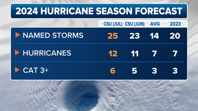
NHC data shows an average season would produce 12 named storms, seven hurricanes and three major hurricanes (Category 3 or higher) from August through November, but this season is expected to be far more active than usual.
An updated hurricane season outlook from Colorado State University (CSU) issued earlier in July predicted even more storms than its previous outlook from early June.
CSU experts are calling for 25 named storms, of which 12 would reach hurricane strength and six would become major hurricanes. The outlook includes the three named storms that have already formed, which means an additional 22 are expected.
This is significantly higher than an average Atlantic hurricane season, which features 14 named storms, seven hurricanes and three major hurricanes.
2024 updated Colorado State University hurricane season forecast.
(FOX Weather)
"Sea surface temperatures averaged across the hurricane Main Development Region of the tropical Atlantic and Caribbean remain near record warm levels," the CSU team wrote, adding those warm waters are an ample source of fuel for tropical development.
In addition, El Niño is gone, and the ensuing neutral or budding La Niña pattern that is likely to be in place for the peak of the hurricane season later this summer will reduce wind shear that would also typically inhibit tropical storm development.