San Francisco slammed by damaging winds as atmospheric river event soaks Northern California
A section of Malibu's Pacific Coast Highway closed again at 3 p.m. Tuesday and will affect all traffic except first responders, recovery workers and utility personnel. The highway is expected to remain closed until at least this weekend.

Atmospheric river brings more than a foot of rain to Northern California
This atmospheric river has brought heavy rain, flooding and strong wind gusts to Northern California. Wind gusts of 87 mph were reported north of San Francisco as well.
Fast Facts:
- Northern California sees a surge of rain and snow as an atmospheric river arrives.
- One injured by tree fall in San Francisco as gusts top 60-80 mph in the Bay Area.
- Heavy rain is leading to flooding, while the Sierra Nevada mountains see significant snowfall.
SAN FRANCISCO – The second in a trio of atmospheric river storms blasted Northern California on Tuesday with heavy rain, damaging wind gusts, feet of mountain snow, and even severe thunderstorms, leaving damage and an injury in the San Francisco area.

A man stranded on an island in Clear Creek in Redding, California, was rescued Sunday morning by the Shasta County Sheriff's Swift Water Rescue Team.
(Shasta County Sheriff's Office)
This second event comes on the heels of a "Pineapple Express" atmospheric river event over the weekend that has pushed rainfall totals to more than 3 inches across the hills north of the Bay Area since the storms began Friday. Higher rain accumulations were found as you climbed in elevation, with reports reaching 10-12 inches of rain along the highest peaks.
The bull's-eye has been in far northern California across Butte and Shasta counties, where over 13 inches and 15 inches of rain, respectively, have already been recorded. An additional 3-8 inches of rain is expected in these areas.
In Siskiyous County, California, near the Oregon border, a neighborhood in Montague was evacuated due to flooding, according to the sheriff's office.
And in the Napa Valley, several landslides were reported on Tuesday evening, as the rain led to unsafe terrain.
One injured when struck by tree in San Francisco
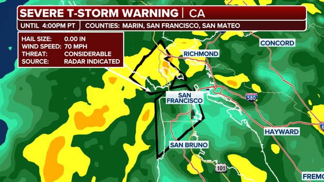
But the storms became more active Tuesday as the atmosphere destabilized. A line of severe thunderstorms pushed through the heart of San Francisco Tuesday afternoon, triggering one of four of the region's first Severe Thunderstorm Warnings of the year so far and the first in San Francisco in five years, according to the FOX Forecast Center.
Wind gusts of 87 mph were reported north of San Francisco on Tuesday afternoon, while San Francisco Airport reported multiple gusts over 50 mph, including a gust of 69 mph.
San Francisco's Fire Department reported responding to several trees and power wires down all over the Bay Area on Tuesday afternoon. One tree fell on a person on San Francisco's Goettingen Street, according to SFFD. The person was taken to a local hospital for treatment.
And about 10 rockslides had been reported north of San Francisco, according to the FOX Forecast Center.
More than 40,000 Californians were without power Tuesday, according to FindEnergy.com.
Pacific Coast Highway closes again due to mudslide threat
On Wednesday, the atmospheric river will weaken as it moves toward Southern California.
As the storms move south into Southern California, light-to-moderate rain can be expected, with the heaviest rain staying west of the main burn scars in San Luis Obispo County.
But it was enough of a threat of rain Tuesday afternoon to force the closure of Malibu's Pacific Coast Highway, which just reopened after last month's devastating Palisades Fire. Officials remain concerned about potential mudslides, landslides and debris flows from a prolonged atmospheric river event.
The closure, from Chautauqua Boulevard to Carbon Beach Terrace, began at 3 p.m. local time and affects all traffic except first responders, recovery workers and utility personnel. The highway is expected to remain closed until at least this weekend.
Elsewhere in Southern California, minor impacts, such as road flooding and minor creek overflows can be expected. In terms of debris flows in burn scar areas, the probability will be very low around the Palisades and Eaton Fires. There is a slightly greater, but still low chance around the Lake Fire burn scar in Santa Barbara County. Overall, the rains this week will be more beneficial than not, according to the FOX Forecast Center.

(FOX Weather)
Heavy snow pasting Sierra Nevada
At higher elevations, snow will fall from Northern California extending into Montana.
Moisture from the atmospheric river has caused up to 40 inches of snow to fall since Friday in northwestern Wyoming and 30 inches in Idaho. An additional 1-3 feet of snow will fall from the southern Cascades of Oregon to the Sawtooth and Salmon River mountains of Idaho and the Bitterroot Mountains of Montana.
Meanwhile, in California, snow levels were around 6,000 feet at the start of the day Tuesday.
As the peak of the storm arrives, colder air from the Gulf of Alaska will bring snow levels down dramatically. By late Tuesday, they will drop as low as 2,000 feet across the Shasta County mountains and 3,000-4,000 feet in the Sierra.
The heaviest snow will fall during the day Tuesday, with snowfall rates of 1-2 inches per hour at times. Snowfall totals of 1-3 feet are anticipated along the Sierra and southern Cascades above 5,500 feet, with up to 4 feet possible over the peaks.
Additionally, snowfall totals of 4-8 inches, with up to 1 foot over the peaks, will be possible across the Coast Range and Shasta County mountains.

(FOX Weather)