Mapped: What a barrage of 56 West Coast atmospheric river events looks like
Atmospheric rivers are long, narrow corridors of concentrated moisture that transport air from tropical regions and release precipitation over generally cooler areas. According to NOAA, these features typically range from 250 to 400 miles wide and can stretch over 1,000 miles in length.

Barrage of winter storms leaves California reservoirs at better than 90% full
As the peak of the snowmelt season begins to slow down, the majority of California’s major reservoirs are at least 90% full - a promising sign for a state that frequently battles drought and associated wildfires.
SACRAMENTO, Calif. - The previous six months have proven to be a tale of the haves and have-nots when it comes to atmospheric river events impacting the West Coast.
According to data from the Scripps Institution of Oceanography, 56 atmospheric rivers impacted the western U.S. during late 2024 and early 2025, with the majority affecting Oregon and Northern California.
Atmospheric rivers are long, narrow corridors of concentrated moisture that transport air from tropical regions and release precipitation over generally cooler areas. According to NOAA, these features typically range from 250 to 400 miles wide and can stretch over 1,000 miles in length.
Forecasters note that Northern California typically experiences about six strong atmospheric rivers every year, but by April 1, that number had already reached nine.
This increase in storm system intensity and frequency led to above-normal precipitation levels, particularly in critical watershed zones, but, in contrast, Southern California saw very few significant storms, receiving only a handful of weak systems.
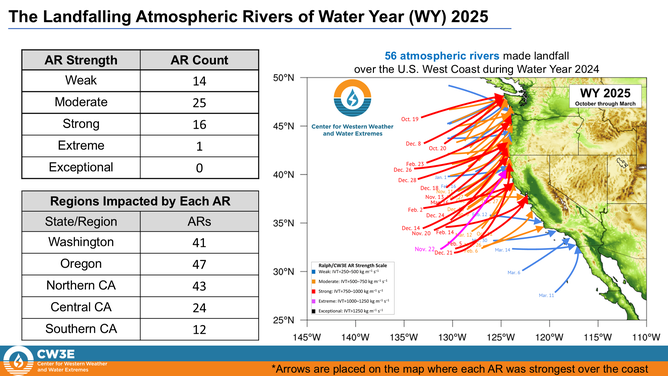
2024-2025 atmospheric river events
(FOX Weather)
As a result, precipitation totals in Southern California dropped to 70% or less of average levels through early March, setting the stage for an increasingly dangerous fire season.
Several counties have already been classified as being in an exceptional drought, the most severe category.
Only one of the atmospheric river events to strike Southern California was rated as moderate, which still caused significant issues for burn-scar communities and along the Pacific Coast Highway.
Mudslides were a common sight, as the lack of vegetation allowed water to accumulate and flow freely.
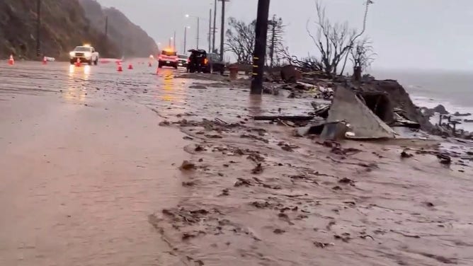
Debris flow on the Pacific Coast Highway.
(Alexandra Datig via Storyful / FOX Weather)
Despite the ending of the wet season, there is a sliver of good news: all of California’s major reservoirs are currently at levels higher than in recent years, with some reaching more than 90% capacity.
Shasta Lake, the state’s largest reservoir, was recently reported to be at approximately 95% capacity, surpassing its historical average by 117%, while Diamond Valley Lake, located southeast of Los Angeles, is at 97% capacity.
Water management officials attribute much of this to a significant snowmelt from the Sierra Nevada, which feeds vital waterways, but with drought conditions intensifying, it's uncertain how long these levels will remain above historical averages.
According to California water authorities, the Sierra Nevada snowpack - which primarily accumulates during atmospheric river events - contributes roughly 30% of the state's annual water supply.

California water reservoirs status
(FOX Weather)
Powerful November event tops atmospheric river list
The most powerful atmospheric river this season was linked to a bomb cyclone that rapidly intensified off the West Coast in November.
The system delivered record-breaking rainfall, mountain snow and hurricane-force winds across much of the West - though Southern California was largely spared.
In Santa Rosa, nearly a foot of rain fell in less than 48 hours, while wind gusts exceeding hurricane strength in the Pacific Northwest caused over half a million power outages.
Tragically, at least two fatalities were reported near Seattle due to falling trees associated with the storm, and several feet of snow blanketed the mountain region.
The storm system received an "extreme" ranking by Scripps or a 4 out of 5 on its AR scale.

Pacific Northwest blasted by Bomb Cyclone
Hundreds of thousands lost power after a bomb cyclone rattled Seattle and other areas in the Northwest. Strong winds knocked trees onto roads and houses and at least 2 people died.