Unrelenting heat to keep US sweating during final month of summer
In August, Americans are in for much of the same above-average heat that has dominated this summer so far. Meanwhile, an active Atlantic hurricane season and the ongoing Southwest Monsoon will contribute to the above-average rainfall for parts of the U.S.

Tropical threat looming for America's East Coast
A tropical disturbance is being tracked in the Atlantic Ocean for the first time since Hurricane Beryl's assault on Texas more than three weeks ago.
The scorching heat is expected to continue through the end of an already sweltering summer, according to NOAA’s latest climate forecast for August 2024.
NOAA’s Climate Prediction Center issued its 30-day outlook for August – the final full month of summer – and it looks like Americans are in for much of the same above-average heat that has dominated this summer so far.
The outlook also shows that an active Atlantic hurricane season and the ongoing Southwest Monsoon are expected to contribute to above-average rainfall for parts of the U.S.
August US temperature outlook
NOAA's temperature outlook shows above-average temperatures across most of the contiguous U.S. and the northeast half of Alaska.
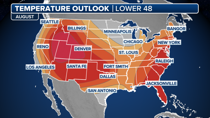
The August 2024 temperature outlook by NOAA's Climate Prediction Center. Deeper red colors represent higher chances of above-average temperatures.
(FOX Weather)
Regions that could see warmer conditions include the Southeast, most of the mid-Atlantic, Northeast and New England. The same can be said for nearly the rest of the country from the Gulf Coast states to the West Coast, with higher chances for parts of the interior West, including Utah, Colorado, Nevada, Wyoming and Idaho.

People walk along the coast as the sun sets on the Pacific Ocean at Windansea Beach in La Jolla during a summer heat wave on July 23, 2024 in San Diego, California. (Photo by Kevin Carter/Getty Images)
(Getty Images)
The Plains, Southeast and Gulf Coast states are forecast to begin August with a heat wave bringing dangerous heat to those regions through next week.
Only the Great Lakes and Upper Midwest are spared from the expected heat, according to the outlook.
August US rainfall outlook
NOAA’s perception outlook shows many parts of the eastern U.S. and parts of Texas, New Mexico and Arizona will see above-average rainfall totals in August.
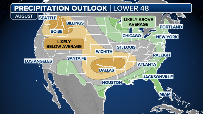
August precipitation outlook from NOAA's Climate Prediction Center.
(FOX Weather)
An active hurricane season in the Atlantic – with a possible new tropical system approaching the Southeast during the first week of August – could easily bring enough rain to exceed monthly normal precipitation for the final month of summer.
Florida, coastal Georgia and the Carolinas could start August with tropical rains as the National Hurricane Center continues to track a system with a medium chance for development within a week.
The Southwest Monsoon season is already in high gear, and the CPC is tracking a slightly enhanced monsoon season across parts of New Mexico and Arizona, where flooding has already been problematic.
In New Mexico, the South Fork and Salt Fork Fire burn scars have been placed under 19 Flash Flood Emergencies since June 19.
More rain could also be troublesome for areas in the Northeast, including Vermont, which just recorded its rainiest day in state history after seeing nearly 8.5 inches on July 30.

Portions of a road are seen washed away after catastrophic flooding in the St. Johnsbury, Vermont, area, on Tuesday, July 30, 2024.
(Littleton Fire Rescue/Facebook)
Meanwhile, models show the Northwest and Plains are more likely to have below-average rainfall. This drier stretch includes much of the Northwest, Great Plains, Mississippi Valley and western Tennessee.
Areas with below-average rainfall and above-average temperatures include areas under increased fire risk, such as Colorado, where firefighters are battling a 5,000-acre blaze.

Watch: Smoke from adjacent fires fill sky north of Denver
A video shared from Colorado shows smoke from the Stone Canyon Fire and Alexander Mountain Fire filling the sky on Tuesday, July 30.