Bryan Norcross: Atlantic low could become Vince in a few days
The isolated low might be over the warm water long enough to take on some tropical characteristics – in other words, it would start drawing some energy from the ocean instead of just the contrast of cold and warm air. The National Hurricane Center is giving that a medium chance of happening over the next several days.

FOX Weather is your Hurricane HQ, streaming free 24/7.
(FOX Weather)
Updated at 9:10 a.m. on Wednesday
A robust cold front extends from the North Atlantic all the way to the Caribbean Sea. Over the next few days, an area of low pressure is forecast to form along the front, then loop to the south and east. As the system tracks over warmer waters, the front will dissipate.
The isolated low might be over the warm water long enough to take on some tropical characteristics – in other words, it would start drawing some energy from the ocean instead of just the contrast of cold and warm air. The National Hurricane Center is giving that a medium chance of happening over the next several days.

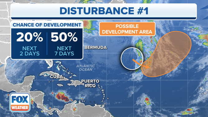
A tropical disturbance in the Atlantic Ocean has a medium chance of developing over the next week.
(FOX Weather)
The system is already producing winds over 40 mph, so it’s likely to instantly be named Vince if it’s designated a subtropical (hybrid) storm or a tropical storm.
If Vince gets named, for our side of the Atlantic, it will be a footnote in the record book – named storm No. 21 of the 2023 hurricane season. It might, however, threaten the Azores – islands well off the coast of Portugal – and then turn into a storm for western Europe.
Dry air is covering the Caribbean Sea, so no development is expected there. We’re just waiting for the Atlantic to calm down so we can call the hurricane season over.