Conditions appear conducive for development in Caribbean -- plus, remembering Hurricane Sandy
There are no signs of organization yet, but clustering thunderstorms in a generally conducive atmospheric environment is often a precursor to a tropical depression developing.
The podcast Tracking the Tropics with Bryan Norcross is now available to stream.
(FOX Weather)
Updated at 10:20 a.m. ET
Tropical Disturbance #1 is a cluster of thunderstorms in the southeastern Caribbean Sea east of the ABC Islands – Aruba, Bonaire, and Curaçao – and just north of Venezuela. There are no signs of organization yet, but clustering thunderstorms in a generally conducive atmospheric environment is often a precursor to a tropical depression developing.
Farther north in the Caribbean, the upper-level winds remain hostile, and in the western part of the basin, the atmosphere is covered in dry air from the continental U.S. But it appears likely, that the system can organize in the southeast Caribbean where the overall environment is most supportive – although not perfect.
The National Hurricane Center is giving the system a high chance of developing into at least a tropical depression over the next few days.
HOW TO WATCH FOX WEATHER ON TV

<strong>Tropical Disturbance #1</strong> is a cluster of thunderstorms in the southeastern Caribbean Sea east of the ABC Islands – Aruba, Bonaire, and Curaçao – and just north of Venezuela.
(FOX Weather)
The forecast steering flow over the next few days would slowly push the system west and northwest through the Caribbean in the general direction of Jamaica and Central America. But all of the islands from Puerto Rico west will likely be impacted by an increase in tropical downpours until the system moves away.
The computer forecast models do not forecast the system to become terribly strong at the current time, though forecasts for just-developing systems are always iffy. Everybody around the central and western Caribbean needs to stay informed.
High pressure across Florida and the Gulf of Mexico will prevent the system from moving north for the next week.
Disturbance #2 is losing its opportunity to develop into at least a subtropical depression over the waters just northwest of Bermuda. A cold front is closing in, and the window of opportunity will likely end today. In any case, beyond a few squalls on Bermuda, it shouldn't be much of an issue.
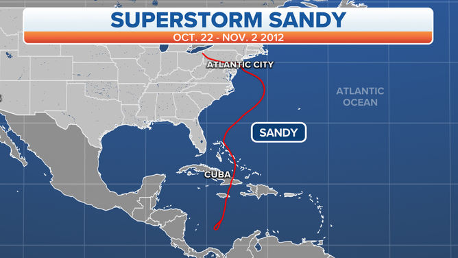
The track of Hurricane Sandy, Oct. 22-Nov. 2, 2012.
(FOX Weather)
Remembering Hurricane Sandy
Ten years ago this evening, Superstorm Sandy made landfall near Atlantic City, New Jersey. The winds in the circulation were not very strong – winds gusted to hurricane strength at a number of locations near the New York and New Jersey coasts, but sustained winds were almost all in the tropical-storm range.
The damage was done by the incredible storm surge related to the giant size of the circulation and the system's angle of approach to the coast. Sandy's vast area of onshore winds forced ocean water into the right angle made by the New Jersey and Long Island, NY coastlines, with New York City at the center of that angle. The water had no place to go except over the beaches and into New York Harbor and up the rivers, bays, and sounds in the New York, New Jersey, and Connecticut region.
The peak storm surge came at high tide in lower Manhattan, taking out power and flooding subway tunnels and other critical infrastructure. The tides in lower and upper Manhattan are out of phase. As bad as Sandy's impacts were, a case can be made that they would have been worse if the storm had made landfall 5 or 6 hours earlier when it was high tide where Long Island Sound and the East River meet near LaGuardia Airport.
In that area, the surge would have impacted water treatment plants, major power stations, food distribution centers, and other critical infrastructure affecting vast areas in the city.
Sandy was a strong reminder that any hurricane of any strength impacting a densely populated area can be a major disaster.
Meteorologically, Sandy was confusing, and the alerting system of the time wasn't designed for that kind of storm. A few days before landfall, the system was forecast to transition into a nor'easter-type storm when it reached Virginia. The National Hurricane Center doesn't handle winter-type storms, so Hurricane Warnings were not issued for the Mid-Atlantic and Northeast coasts.
At a technical level, the system was forecast to transition from Hurricane Sandy to Post-Tropical Cyclone Sandy. This well-advertised name-change confused emergency planners into thinking the storm surge would be less severe, so evacuation orders were delayed. In fact, the transition increased the diameter of the storm, which made water levels higher.
At that time, I was managing the weather-presentation department at The Weather Channel, along with my regular duties as Hurricane Specialist. I thought Post-Tropical Cyclone was an inappropriate label for a very dangerous storm. "Post," I thought, implied that the threat was over, but it was actually increasing. That's when I came up with the name Superstorm Sandy to convey that the system was a continuing high-level threat.
Sandy's impacts continue to be felt in the greater New York City region. The lifespan of train tunnels was shortened. Beach communities were changed forever. And new infrastructure has to be built with higher water levels in mind.
Hurricanes don't impact New York City and the surrounding area very often, but the history book lists a number of tropical systems tracking near the city, including a Category 3 that hit head-on in 1821. So Sandy was less of a fluke and more of a wake-up call. Living along the coast means living with hurricanes. It's just a matter of time.
FOX Weather Hurricane Specialist Bryan Norcross has a podcast, Tracking the Tropics with Bryan Norcross, available now on FOX News Audio. You can get it on your device by clicking here.