Bryan Norcross: Development expected in the Gulf and watching the Atlantic
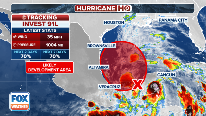
The National Hurricane Center is giving Invest 91L a high chance of developing into at least a tropical depression in the Gulf of Mexico.
Invest 91L forms in Gulf of Mexico as Texas, Louisiana brace for flooding rain
The National Hurricane Center says a broad area of low pressure, officially designated Invest 91L, has formed over the Bay of Campeche and has a high chance of developing into a tropical depression or tropical storm as it moves over the Gulf of Mexico and sends heavy rain into areas of Texas and Louisiana over the next few days.
Updated Monday at 9 a.m. ET
A weak disturbance-moisture surge from the Caribbean is merging with a broad low-pressure system over Central America. That combo system is forecast to lift north into the southern Gulf of Mexico. The upper-air pattern appears conducive for consolidation of the large-diameter circulation into at least a tropical depression.
Whether Disturbance #1 (Invest 91L) organizes or not, the winds will be brisk north of the center and might reach tropical storm force. The flow around the system will create a broad channel of tropical moisture that is likely to impact the coastal areas of northern Mexico, Texas and possibly part of Louisiana.
There is a risk of flooding along and near the Texas coast, including the Houston metro area and possibly in southwestern Louisiana. South Texas is in a drought, so more rain will soak in there, but flash flooding is still possible.
The National Hurricane Center gives the potential system a high chance of developing into a tropical depression.

A disturbance in the Gulf of Mexico has a high chance of developing in the next 2 days.
(FOX Weather)
The extremely strong heat-dome high-pressure system over the Northeast U.S. will deflect the system toward the coast. The air pressure difference between the strong high to the north and the developing tropical system will cause extra-strong winds in the northwest Gulf. Expect these strong onshore winds whether we end up with a tropical depression, tropical storm or just a broad disorganized disturbance.
On the current schedule, the peak of the onshore wind and rain will occur on Wednesday, possibly into Thursday morning. At about the same time, modest storm surge will also impact coastal regions. Boaters should stay aware of the forecasts for water rise in their area.
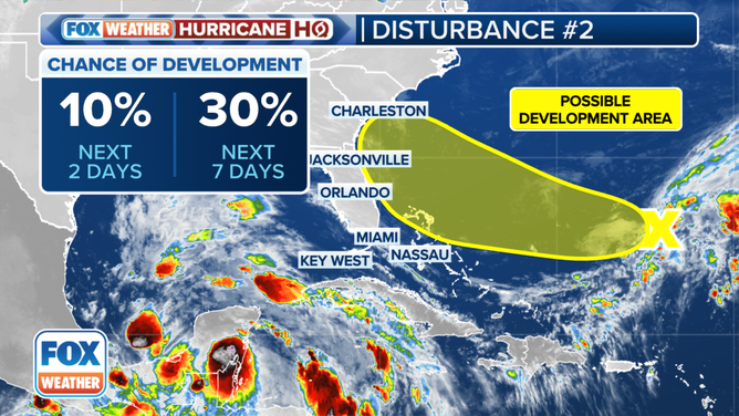
On the other side of Florida, the old front that was part of the deluge that swamped the southern peninsula last week has stalled east of the Bahamas. Computer forecast models indicate that the tail of the front and its associated upper-level system might develop into an area of low pressure over the next few days. This development would initially be non-tropical, but it could eventually morph into a system with tropical characteristics.

The outlook for a tropical disturbance in the southwestern Atlantic.
(FOX Weather)
We call this system Disturbance #2.
The same blocking heat-dome high-pressure system would likely push it toward Florida or the Southeast coast. It doesn't appear there would be an opportunity for it to intensify very much, but if it develops, the onshore winds to the north of the low-pressure center will likely be quite brisk mid- to late-week.
The National Hurricane Center still has the tropical development odds in the low category. It's unclear if the system, if and when it develops, can shed its non-tropical origins before it reaches the coast. Until the system develops, if it does, forecasts will be all over the place, so stay informed for now. It’s not an atmospheric pattern that would support a rapidly strengthening system in any case.
Some long-range computer forecast models indicate that the big Central American low could spawn a second Gulf disturbance. That would happen 6 or 7 days from now, so it's just something to keep in mind.
The typical tropical development areas in the Atlantic and the Caribbean continue to be quiet.
