Bryan Norcross: Flood threat continues for southern Florida and two tropical areas to watch
This moisture channel is equivalent to atmospheric rivers that are common along the West Coast of the U.S. It's a relatively narrow band of moisture squeezed between two competing weather systems. The warmer-than-normal waters to the south are likely enhancing the amount of moisture flowing over South Florida.

Intense rain swamps South Florida as tropical disturbance 90L crosses state
The multiday heavy rain event across Florida moves onto day three even as Invest 90L pulls away from the state. Deep tropical moisture and a stalled font remain in place across Florida and will will continue to foster repeated rounds of torrential downpours and instances of flash flooding through the end of the week.
The atmosphere is stuck in a pattern that is funneling a river of extremely moist air over the southern part of the Florida peninsula. A dip in the jet stream to the north and high pressure to the east are converging to pull saturated air from the Caribbean and Central America across Florida into the Atlantic.
The ground is waterlogged in many parts of South Florida, which means the additional rain won’t sink in or run off quickly. Alerts for potential widespread flooding will continue in effect.
This moisture channel is equivalent to atmospheric rivers that are common along the West Coast of the U.S. It's a relatively narrow band of moisture squeezed between two competing weather systems. The warmer-than-normal waters to the south are likely enhancing the amount of moisture flowing over South Florida.
This atmospheric river is forecast to move little through the weekend, but the amount of moisture in the flow might decrease a bit, so we should see longer periods with no rain.
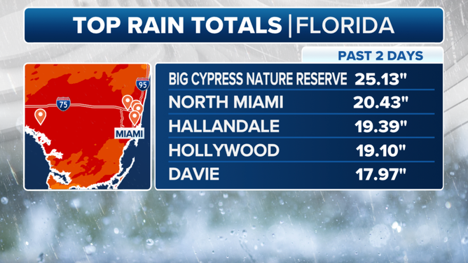
Florida rainfall totals.
(FOX Weather)
The atmospheric pattern will continue to support very heavy rain at times across the southern half of the Florida peninsula. Stay alert for warnings about potential flooding, and if you see a flooded area, remember: Turn around, don't drown. Flooded roads look like flooded canals.
The heavy rain is coming in waves because disturbances are caught in the flow. When a disturbance comes by, there's another round of downpours.
SOUTH FLORIDA FACES ‘HIGH RISK’ OF FLASH FLOODING AFTER-20 PLUS INCHES OF RAINFALL
One especially well-organized disturbance is moving toward the waters off the Carolinas. A more organized low-pressure system might develop off the East Coast. It’s officially being designated Invest 90-L meaning that weather models are being run to "investigate" it. It’s still just a disturbance, however.
The upper-level winds are forecast to remain hostile to tropical development, but the National Hurricane Center is giving it a slight chance of gaining sufficient tropical in the next few days characteristics to become a depression or a subtropical or tropical storm over the Gulf Stream. The only potential threat to land appears to be to eastern Atlantic Canada. The system would not be tropical by that time, even if it briefly develops.
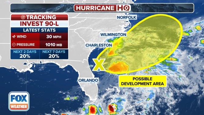
Tracking Invest 90L in the southwest Atlantic.
(FOX Weather)
Farther south, a broad area of low pressure over Central America is typical this time of year. When a tropical disturbance from the Atlantic reaches the western Caribbean, it can be deflected north into the southern Gulf of Mexico by the Central American low's circulation, benefit from its interaction with the low, and turn into an independent system over the warm waters of the Gulf.
There is a decent chance that will happen early next week, so the National Hurricane Center has painted a potential development area in the southwestern Gulf. We’re calling this one Potential Disturbance #2. The atmospheric pattern over that part of the Gulf appears reasonably conducive to a system organizing. People on the Mexican coast and in South Texas should stay aware of developments late in the week and over the weekend.
There is some chance that either or both systems could briefly get a name. The first two names on the list are Alberto and Beryl.
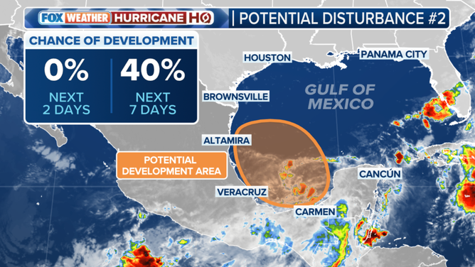
Tracking an area of disturbed weather in the Bay of Campeche.
(FOX Weather)
The large Central American low-pressure area might also trigger a tropical system to organize in the Pacific.
These are the kinds of tropical developments we expect in June. Whether they organize into named storms or not has no relation to what will happen later in the season.
Next week, high pressure should control Florida's weather, with the deep moisture pushed to the western Gulf of Mexico. The flow around the high blowing across Florida, over the super-warm Gulf, and into the Southeast and Midwest will contribute to a major heat wave in the eastern part of the country.
Saharan dust covers the tropical Atlantic up to the Caribbean so that nothing can develop there in the immediate future.
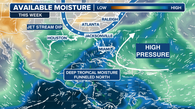
Tropical moisture set up.
(FOX Weather)