Bryan Norcross: Warnings, watches likely for some Caribbean islands today
The system is looking increasingly healthy, and there's a high consensus from the computer forecast models that it will organize near the northeast Caribbean and eventually turn into Tropical Storm and possibly Hurricane Ernesto.

FOX Weather is your Hurricane HQ.
(FOX Weather)
Updated at 10:45 a.m. on Sunday, Aug. 11, 2024
The well-developed tropical disturbance moving across the Atlantic is officially tagged Invest 98L by the National Hurricane Center.
The system is looking increasingly healthy, and there's a high consensus from the computer forecast models that it will organize near the northeast Caribbean and eventually turn into Tropical Storm and possibly Hurricane Ernesto.
The National Hurricane Center has the chances in the very high category that it will become at least a tropical depression somewhere in the red potential development zone.
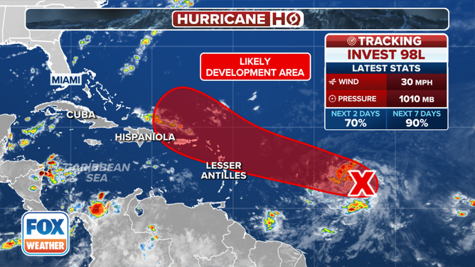
This graphic shows the latest information on Invest 98L.
(FOX Weather)
The big question is, when will it become organized and attain strong enough winds to be named Ernesto? The various computer forecasts disagree on where that will happen. Everybody in the northeast Caribbean, especially in Puerto Rico, the Virgin Islands and the Dominican Republic, needs to stay in close touch with the forecasts. The water is very warm, and the atmospheric environment is forecast to be conducive for the system to strengthen quickly.
Somewhere in the general vicinity of Puerto Rico, eventual-Ernesto is forecast to make a sharp turn to the north and strengthen. Most forecast scenarios keep the likely hurricane well offshore of the U.S. East Coast. The outer envelope of track possibilities still shows impacts to the southeastern Bahamas and a close call in the Carolinas, but that's a very low-probability scenario based on what we know right now.
Dangerous beach conditions will be likely along much of the East Coast around next weekend, however, even if the storm stays well offshore.
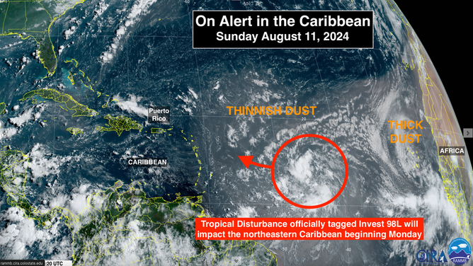
This satellite image shows Invest 98L.
A strong dip in the jet stream is forecast to drive a cold front through the Northeast this week. It will also grab likely-Ernesto and pull it north. There is unanimity in this scenario. The only question is whether the storm heads due north where it could affect Atlantic Canada or curves into the North Atlantic, avoiding land.
On the far side of the Atlantic, a large and robust tropical disturbance has moved off Africa. It's plowing into a dense cloud of Saharan dust, however. In addition, upper winds are forecast to be hostile. So no significant development is expected.
That's all we have on the table right now, which is great for this time of August.