Bryan Norcross: Bermuda on hurricane alert as Ernesto slowly moves away from Caribbean
Flooding and mudslides are possible, especially on the southeastern slopes where the corridor of tropical air feeding into the storm runs into the mountains. The weather should slowly improve during the day as Ernesto pulls away to the north.

FOX Weather is your Hurricane HQ.
(FOX Weather)
Updated at 9:30 a.m. ET Wednesday, August 14, 2024.
The tail of Tropical Storm Ernesto is still causing very gusty winds and torrential rains over Puerto Rico and the Virgin Islands.
Flooding and mudslides are possible, especially on the southeastern slopes where the corridor of tropical air feeding into the storm runs into the mountains. The weather should slowly improve during the day as Ernesto pulls away to the north.
The storm is over very warm water under conducive-for-strengthening atmospheric conditions but hasn't yet shed dry air that has wrapped into its circulation. The National Hurricane Center is forecasting significant strengthening as the storm heads in the general direction of Bermuda. On the current schedule, the island will feel the impacts of likely-Hurricane Ernesto late Friday and Saturday.
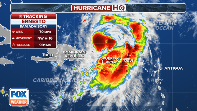
Current stats for Tropical Storm Ernesto.
(FOX Weather)
The modern computer forecast models designed to predict how strong a storm is going to get indicate that Ernesto will turn into a large, powerful hurricane over the next couple of days. The current forecast calls for the storm to peak at Category 3 intensity, which means a Category 4 is possible.
Bermuda is a small cluster of islands, and the slice of the likely hurricane with the strongest winds will not be terribly wide, so the odds of the worst of the storm passing over the island are never high. But it happens. Everybody in Bermuda needs to pay attention to local information and instructions. The island is well fortified against hurricanes, but it's impossible to fully defend against a direct hit from a powerful storm.
Unfortunately, the jet-stream dip that is dragging Ernesto north will lose its grip about the time the storm is approaching Bermuda, so the system's forward speed will slow significantly. Over the weekend, another strong dip will come along that should scoop Ernesto up and yank it into the North Atlantic, where it will become a strong non-tropical storm.
Eastern Atlantic Canada could be impacted next week. The only threat to the U.S. will be high surf and dangerous ocean conditions beginning in the Southeast on Friday and spreading north over the weekend.
Otherwise, no other tropical systems are forecast to form in the next week, at least. And yes, that's surprising and great.