Bryan Norcross: Hurricane Ernesto to make its closest approach to Bermuda on Saturday
The storm is on track to impact Bermuda late Friday through Saturday. A Hurricane Warning is in effect.

FOX Weather is your Hurricane HQ.
(FOX Weather)
Updated 9:30 a.m. ET Thursday, August 15, 2024.
Hurricane Ernesto is slowly developing an inner core, which should allow it to continue intensifying as it moves to the north, away from the Caribbean. The storm is on track to impact Bermuda late Friday through Saturday. A Hurricane Warning is in effect.
The National Hurricane Center is forecasting Ernesto to reach Category 3 strength Friday. The atmospheric pattern might become a bit more hostile later in the day and over the weekend, so the current expectation is that the storm will weaken slightly by the time it is in the vicinity of Bermuda. The current forecast is for a Category 2 at that time, so residents of Bermuda should prepare for a Category 3.
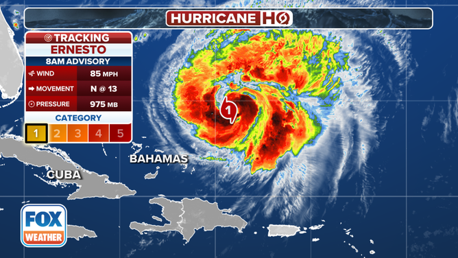
Current stats for Hurricane Ernesto.
(FOX Weather)
More important than the possible slight weakening is that Ernesto is forecast to grow in diameter and slow down as it approaches Bermuda. The dip in the jet stream currently pulling it north will lose its grip on the storm tomorrow. Another strong jet stream dip moving across the northern US will scoop the storm to the north later in the weekend.
Unfortunately, the timing of this handoff and the decrease in Ernesto's forward motion look like they will happen while the system is near Bermuda. This, combined with the larger size, will extend the duration of the impacts.
As Ernesto is propelled into the North Atlantic by the second jet stream dip early next week, it could come close to eastern Atlantic Canada. Otherwise, the storm won't directly impact any other land areas. It will, however, generate strong swells that will reach the Southeast coast tomorrow and most of the US East Coast over the weekend. Dangerous surf and strong coastal currents are likely.
Ernesto's tail, with winds gusting to near hurricane strength and torrential rain, swept across Puerto Rico on Wednesday. Several rivers across the island were pushed into major flood stage, and power outages were widespread. Now, drier air is moving in behind the storm.
Otherwise, the weather pattern over the tropical Atlantic continues to be hostile to storm development, so nothing is expected for at least the next week.