Bryan Norcross: Long-duration impacts begin Friday on Bermuda from Hurricane Ernesto
A little bit of good news is that Ernesto looks likely to be near its peak intensity. The atmospheric pattern around the storm is gradually becoming more hostile, which should limit the large storm's ability to strengthen much.

FOX Weather is your Hurricane HQ.
(FOX Weather)
Updated 10 a.m. ET Friday, August 16, 2024.
Outer bands with gusty winds and heavy rain will move over Bermuda beginning later Friday. Conditions will deteriorate through tonight, with maximum impacts during the day tomorrow on the current schedule. Winds will slowly decrease overnight. Outer bands on the back side will continue rotating over the island on Sunday.
Hurricane Ernesto is a large storm and will slow down when it's in the vicinity of Bermuda, which will prolong the duration of the impacts. The jet stream dip pulling Ernesto north on Friday is forecast to lose its grip as it moves off to the east. The next dip won't arrive until late in the weekend, leaving Ernesto to drift.
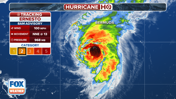
Tracking Hurricane Ernesto.
(FOX Weather)
A little bit of good news is that Ernesto looks likely to be near its peak intensity. The atmospheric pattern around the storm is gradually becoming more hostile, which should limit the large storm's ability to strengthen much. The National Hurricane Center shows Ernesto's top winds slowly decreasing as it passes Bermuda. But the decrease may not be noticeable because of the large size of the circulation.
It's also critical where the center tracks. Currently, the strongest winds are in the northeastern part of the storm. If the center tracks just east of Bermuda, the strongest winds will be offshore. It's too close to call, even with the storm bearing down.
Bermuda is well-equipped to deal with hurricanes, but long-duration events are more likely to cause problems. The winds will seem relentless, and extremely dangerous storm surges will pound the coastline where the winds are blowing onshore. Be ready. Hunker down. Stay safe.
Otherwise, at this time of year, we normally look off the coast of Africa for disturbances that can develop into tropical storms and hurricanes. Currently, however, the African systems are tracking so far north, they are running slam into Saharan dust. So for now, nothing is likely to develop for at least the next week.