Bryan Norcross: Conditions will slowly improve on Bermuda after Hurricane Ernesto makes a direct hit on island
Ernesto will slowly move away to the north today, and conditions will improve.

FOX Weather is your Hurricane HQ.
(FOX Weather / FOX Weather)
Updated Aug. 17, 2024 at 10:40 a.m. ET.
The center of the large, ragged eye of Hurricane Ernesto passed over the island of Bermuda around 4:30 AM ET. Official measurements were taken at the National Museum of Bermuda, which is located on a small island north of the Bermuda archipelago. At that location, the winds blew out of the east through the night, then went calm just after 6:00 AM when they switched to the west. At their peak, sustained winds were blowing about 85 mph with gusts to about 100 mph.
Ernesto will slowly move away to the north today, and conditions will improve. Dry air wrapped into the system, which helped keep it from intensifying quite as much as forecast and will also limit the impacts of the somewhat eroded back side of the storm. Gusty winds and bands of heavy rain will continue over the island today, but they won’t be as intense or long-lasting as they were on the front side.
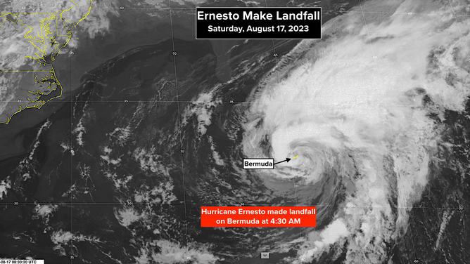
Map showing Hurricane Ernesto as it made landfall in Bermuda at 4:30 a.m.
(FOX Weather / FOX Weather)
By tomorrow, conditions on Bermuda will have dramatically improved, except for continued impacts along the coast from high surf and strong swells radiating out from Ernesto.
The U.S. East Coast is also being impacted by the energy that large-diameter Hurricane Ernesto is putting into the ocean. Dangerous surf and intense coastal currents will continue to impact Atlantic beaches into early next week. Beach erosion will continue to occur until the swells emanating from the hurricane subside.
Ernesto will evolve into a non-tropical system over the North Atlantic. Far eastern Atlantic Canada may feel the effects of what’s left of Ernesto.
The peak of the Atlantic hurricane season normally starts on August 20, but this year, it doesn’t appear there will be any active systems on that date. Dry air and Saharan dust continue to dominate the tropical Atlantic. That, combined with the unusually far north trajectory of the disturbances moving off Africa, is keeping the Atlantic calm.
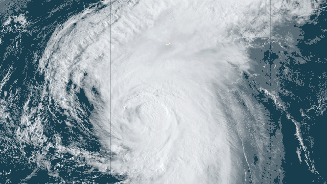
Hurricane Ernesto swirls toward Bermuda in this satellite loop generated Aug. 16, 2024.
(NOAA / NOAA)
Earlier in the season, the disturbance that became Hurricane Beryl formed unusually far south. Now, disturbances are farther north than normal. There’s no obvious reason that this is happening beyond the randomness of the daily weather pattern.
The macro factors that make hurricane season busy are still in place, so significant activity is expected once the weather pattern settles into something closer to an average mode.
Recall that in 2022, the tropics took August off and then exploded with activity in September, including Hurricane Ian. Hopefully, nothing like that will happen this year, but we’re only in the first act of the season.