Bryan Norcross: Ernesto heads to North Atlantic as we remember morning after Hurricane Camille 55 years ago
Ernesto evolved into a giant system with the area of tropical-storm-force winds over 400 miles across. Since it's slow-moving, the storm's effects lingered longer than the island usually experiences.

FOX Weather is your Hurricane HQ.
(FOX Weather)
Updated at 9:30 a.m. ET on Sunday, Aug. 18, 2024
Tropical Storm Ernesto is slowly moving away from Bermuda. A few gusty showers will still rotate over the island, but the worst of it is over.
Ernesto evolved into a giant system with the area of tropical-storm-force winds over 400 miles across. Since it's slow-moving, the storm's effects lingered longer than the island usually experiences. But fortunately, the hurricane was never able to develop a well-organized core, which meant it couldn't strengthen as much as was feared.
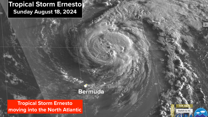
This is a satellite image of Tropical Storm Ernesto on Sunday, Aug. 18, 2024.
(NOAA)
Ernesto will transition into a strong non-tropical system as it approaches far eastern Atlantic Canada late tomorrow. Any effects on land there will be a glancing blow. The jet stream will pick up the storm and be speeding it along by that time. Dangerous surf and strong coastal currents continue along the East Coast of the U.S. Use care if you're going to the beach this weekend.
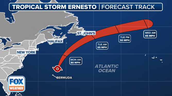
This graphic shows the forecast track for Tropical Storm Ernesto.
(FOX Weather)
Elsewhere in the Atlantic, nothing is forecast to develop for the next week. But long-range computer models show the tropics coming alive the last week of August. It would be more unusual if they didn't.
Thinking back to that epic weekend in the middle of August 55 years ago, Max Yasgur's dairy farm in Bethel, New York, was the venue for a monumental concert for the ages. It was called Woodstock because the event was supposed to be held in the town of Woodstock, New York, about 40 miles away. In the end, almost a half-million people found the new site, tuned in, turned on, and reveled in the mud and the moment that changed music history.
That same weekend, the Apollo 11 astronauts – back from the Moon and out of quarantine – were celebrated in a parade in downtown Houston. And Hurricane Camille mauled the Mississippi Gulf Coast. It was a Monday morning 55 years ago today when residents and rescuers first got a look of what Camille had done the night before.
The day before landfall in Mississippi, Camille was forecast to come ashore in the Florida Panhandle, where Hurricane Warnings were in effect. (Hurricane Warnings weren't issued for the entire Mississippi coast until 9 a.m. the next morning – 14.5 hours before landfall.)
I was a young disc jockey on WTAI-AM in Eau Gallie, Florida. (Eau Gallie and Melbourne subsequently merged to become the new, larger Melbourne.).
A station policy said that we would cover any hurricane that was affecting Florida, so I broadcast the new advisories as they came in. Here I am on WTAI on August 16, 1969, the afternoon before Camille made landfall.
The satellite loop was made in modern times by merging the still daylight images from 1969 into a sequence, so now we can get an idea how Camille moved and grew, even though the navigation jumps around. We didn’t have that technology in the late 60s.
Hurricane Camille was reanalyzed on the 50th anniversary of the landfall. A team of scientists from NOAA and the National Hurricane Center scoured the data and reports from that time, then applied our modern understanding of how hurricanes work. They concluded that Camille had 175-mph sustained winds when it made landfall near Bay St. Louis, Mississippi, at around 11:30 p.m. CT the night of August 17, 1969 – the second-strongest landfall wind speed in the U.S. record book.
As part of the reanalysis project, NOAA researcher Margie Keiper meticulously assembled this radar sequence covering the hours leading up to landfall from still images of the government radar display in New Orleans.

Watch: Hurricane Camille radar loop in 1969
This video shows the radar loop as Hurricane Camille approached the Mississippi coast on Aug. 17, 1969.
Storm surge over 20 feet above normal high tide obliterated the Mississippi coast. I saw it firsthand that following February of 1970, driving to Mardi Gras in New Orleans. From U.S. 90 along the coast, nothing within sight was more than a shell, and most buildings were a pile of rubble or swept away.
Nobody imagined a hurricane could produce a higher storm surge than Camille. But Hurricane Katrina did it on the same piece of coastline 36 years later.
You might have heard about a hurricane party in an apartment house near the Gulf of Mexico that was demolished in the storm. It didn't happen. But the story lingers.
In case you missed it, here's Don Larson's incredible story. Don rode out the storm in Gulfport, Mississippi, and lived to tell about it and to write about it.
The lessons from Camille are many. But at the top of the list is the reminder of how quickly hurricanes can intensify in the Gulf. Any hurricane plan that takes more than about 36 hours to execute is not a hurricane plan that covers fast-developing monsters like Camille.